

Tsunamis
NOAA is developing methods and tools to reduce the tsunami hazard and protect lives and property.
Tsunami Warning System Improved
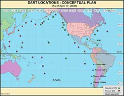
Planned locations of 39 DART™-II buoy stations.
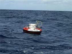
DART™-II Buoy
NOAA’s Pacific Marine Environmental Laboratory (PMEL) in Seattle, WA, designed Deep-ocean Assessment and Reporting of Tsunamis (DART™-II) technology, which provides two-way communication capabilities, allowing engineers the ability to troubleshoot these systems from the lab and repair the systems remotely when possible.
The new capability minimizes system downtime, especially in the harsh winter conditions of the North Pacific; and moreover, saves money by not having to deploy a ship to make this type of repair.
PMEL scientists also created tsunami impact forecast models for nine major coastal communities, providing much-needed information for inundation maps.
Plans call for the U.S. Tsunami warning network to total 39 DART™ II buoy stations by mid-summer 2008 (32 in the Pacific and seven in the Atlantic Basin).
Unnecessary Evacuations Prevented
The November 15, 2006, tsunami from an earthquake near Kurile Island, Russia, marked the first time that DART™ Buoys, tide gauges, and models came together and saved many people the time and cost of an unnecessary evacuation, yet appropriately provided caution where warranted. Six DART™ Buoys were vital tools involved in the forecast.
Animations displaying qualitative information about the tsunami propagation including tsunami wave interaction with ocean floor bathymetric features, and neighboring coastlines can be viewed at the NOAA Center for Tsunami Research Web Page at http://nctr.pmel.noaa.gov/index.html.
This also marked the first time Hawaii issued tsunami advisories to people on beaches.
PREEMINENT RESEARCH
The Pacific Marine Environmental Laboratory (PMEL) has been an international leader in tsunami research since 1973, pioneering the development of a deep-ocean, real-time tsunami monitoring network and improved tsunami forecasts.
Measurement: PMEL scientists identified the requirements for a tsunami measurement system. The first-generation DART™ design featured an automatic detection and reporting rule triggered by waves of a certain height. The DART™ II design incorporated two-way communications enabling tsunami data transmission on demand, independently of the automatic rule; this capability allows the measurement and reporting of tsunamis with wave heights below the autoreporting threshold. The next generation DART™ ETD (Easy To Deploy) buoy is presently under development at PMEL.
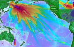
MOST model simulation of tsunami on November 15, 2006 Andreanof Island, AK.
Modeling: The NOAA Center for Tsunami Research (NCTR) is developing numerical models for faster and more reliable forecasts of tsunamis. Forecast models provide an estimate of wave arrival time, wave height and inundation area immediately after a tsunami event. Tsunami forecast models are run in real time while a tsunami is propagating in the open ocean, consequently they are designed to perform under very stringent time limitations.
The MOST (Method of Splitting Tsunami) model, a suite of numerical simulation codes capable of simulating three processes of tsunami evolution: earthquake, transoceanic propagation, and inundation of dry land, was developed by PMEL and the University of Southern California.
Inundation modeling tries to predict the tsunami generation, wave routes to the impact zone, and inundation along the coast. High resolution bathymetric and topographic information is needed to create accurate inundation maps. Inundation studies and maps are used by emergency managers and urban planners to establish evacuation routes and the location of vital infrastructure.
Forecasting: To forecast tsunamis, scientists enter the size of the earthquake and begin looking for matching scenarios in a database of pre-computed tsunami forecasts. Once a DART™ buoy measures a tsunami, those data are added and the forecast model is adjusted. The forecast software produces estimates of tsunami characteristics that help the forecaster determine impacted communities; tsunami size; and arrival time. The results are made available through a user-friendly interface to aid hazard assessment and decision making by emergency managers.
The next generation forecast tools for tsunami warning and mitigation are being developed in close collaboration with Tsunami Warning Centers and academia. The SIFT (Short-term Inundation Forecasting for Tsunamis) system is under development for operational use in National Weather Service Tsunami Warning Centers. Forecast products include estimates of tsunami amplitudes, flow velocities and arrival times for offshore, coastal and inundation areas.
VALUE TO SOCIETY
Scientists at OAR are dedicated to reducing the loss of life and property that result from tsunamis.
- Since 1900, over 200 tsunami events were observed or caused effects on the coasts of the United States and its territories. These events caused more than 500 deaths and more than $186 million in damages, which included damage to buildings, piers, ferry terminals, and boat harbors.
- As of November 2006, NOAA’s National Weather Service has recognized 37 TsunamiReady sites in 10 states, Puerto Rico and Guam. The TsunamiReady program sets minimum guidelines for communities to follow for adequate tsunami readiness. For more information, see http://www.tsunamiready.noaa.gov/
- False tsunami warnings result in additional significant economic impact. The State of Hawaii estimated $40 million in evacuation costs from a 1986 false tsunami warning.
To Learn More, Visit These Sites:
NOAA Center for Tsunami Research: http://nctr.pmel.noaa.gov/index.html
To Work or Study at OAR, Visit These Sites:
NOAA Careers: http://www.careers.noaa.gov
Hollings Scholarships:
http://www.orau.gov/noaa/HollingsScholarship/
Knauss Fellowships: http://www.seagrant.noaa.gov/knauss/
June 2007