

Hurricanes
OAR scientists’ models, data collection and analyses have contributed to the National Weather Service’s improved average hurricane track forecasts. Today, the average 5-day track forecast is as good as the 3-day track forecast was ten years ago.
Improving Hurricane Track & Intensity Forecasts
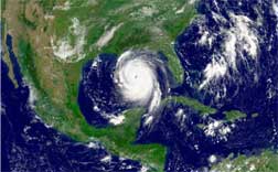
Hurricane Katrina
Since 2004, the Atlantic Oceanographic and Meteorological Lab (AOML) improved hurricane surface wind speed estimates by 15 percent by successfully implementing airborne passive microwave technology on NOAA hurricane aircraft. In 2005, AOML added airborne Doppler 3D wind estimates to the data available to the new generation of NOAA hurricane models. By providing new analyses of these unique data sources, AOML is directly improving the operational assessment of hurricane intensity.
Prior to the start of the 2006 Atlantic Hurricane Season, upgrades to the Geophysical Fluid Dynamic Lab’s (GFDL’s) hurricane forecast model were incorporated into operations at the National Weather Service. Scientists at GFDL and the University of Rhode Island collaborated to improve the GFDL Model.
The upgraded model is expected to improve GFDL model intensity forecasts. Test runs showed about a 10 percent reduction in intensity error for 2-to-4 day lead time and 20 percent for 5-day lead time.
Predicting Hurricane Losses
AOML contributed to the first public model to predict hurricane losses for the State of Florida, developed by the International Hurricane Research Center. AOML developed models to predict the areas that will be subject to hurricane force winds, and Florida State University developed the models to predict the hurricane’s path.
Helping Hurricane Recovery
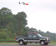
Aerosonde vehicle. Photo courtesy of NASA.
Responding to the need for information in the aftermath of Hurricanes Katrina and Rita, the Louisiana Sea Grant College Program launched the Louisiana Hurricane Resources website at www.laseagrant.org/hurricane/index.htm. Residents, business owners, and community leaders used this site to find the information they needed on wetlands, seafood, water quality, ports, economic impacts and rebuilding concerns, and to make decisions about their immediate future. In its first 10 weeks of operation, more than 6,400 people visited the site.
Pilotless Aircraft Flies in Hurricane Force Winds for First Time
During the 2007 Hurricane Season, AOML, and NASA successfully flew an Aerosonde® Unmanned Aircraft System (UAS) through hurricane-force winds and at record low altitudes into Tropical Cyclone Noel. The use of UAS to monitor tropical storms and hurricanes is important because UAS thermodynamic and wind observations can be obtained at altitudes unsafe for manned aircraft and in very high spatial resolution making these unique data highly desirable.
PREEMINENT RESEARCH
Eyewall Hurricane Katrina, August 28, 2005
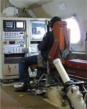
Dropsonde Operator
OAR Scientists are conducting preeminent research to improve our understanding of the physical processes of tropical storms and to advance the hurricane models used by the National Weather Service to predict the hurricane’s path and intensity.
Hurricane Formation: OAR scientists are learning more about hurricane formation each year. They investigate how Saharan dust storms affect hurricane development and intensity change; how tropical disturbances develop into hurricanes; and the structure and evolution of hurricanes that make landfall and eventually decay over land.
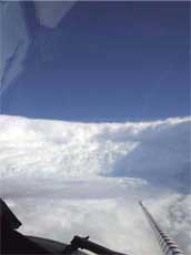
Hurricane Hunters Improve Track and Intensity Forecasts: OAR scientists fly into the eye of these dangerous storms on NOAA Aircraft Operations Center research/reconnaissance aircraft to collect and analyze data crucial to improving our prediction of hurricane track and intensity. Research teams analyze data from field programs, develop numerical hurricane models, conduct theoretical studies of hurricanes, and prepare storm surge atlases. Global Positioning System (GPS) dropsondes, an innovative technology developed by the scientists at AOML, provide key data in real time to the National Hurricane Center and are crucial tools for studying the wind structure in the eyewall region of hurricanes.
The Hurricane Intensity Forecasting Experiment (IFEX) will improve our understanding and prediction of hurricane intensity change by collecting observations that will enhance current operational models and aid in the development of the next-generation operational hurricane model, the Hurricane Weather Research and Forecasting model (HWRF). Observations are being collected at different stages of the hurricane, from formation to peak intensity, to subsequent landfall or decay over open water.
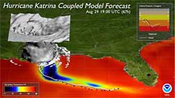
Hurricane Katrina Coupled Model Forecast
Hurricane Forecast Models: The accuracy of NOAA’s hurricane forecasts is closely tied to improvements in computer-based numerical weather prediction models. Scientists at the Geophysical Fluid Dynamics Lab developed and continue to improve the GFDL coupled hurricane forecast model.
AOML, in partnership with NOAA’s Environmental Satellite, Data and Information Service, created the only operational statistical-dynamical intensity model, known as SHIPS, which recently incorporated a new understanding of ocean heat content.
VALUE TO SOCIETY
OAR scientists have advanced hurricane models and monitoring to significantly improve hurricane track and intensity forecasts used by local forecasters, emergency managers, and millions of US residents.
- OAR scientists’ models, data collection and analysis have contributed to the National Hurricane Center’s improved average hurricane track forecasts. Today, the average 5-day track forecast is as good as the 3-day track forecast was ten years ago.
- Track forecast improvements on the order of 20% are possible using dropsonde data collected by NOAA’s hurricane hunters. A 20% reduction in track errors should reduce the average warning area by at least 10% (34 miles), saving the public more than $45 million over 5 years.
To Learn More, Visit These Sites:
Geophysical Fluid Dynamics Lab: http://www.gfdl.noaa.gov/research/weather/hurricane.html
Atlantic Oceanographic & Meteorological Lab: http://www.aoml.noaa.gov/
To Work or Study at OAR, Visit These Sites:
NOAA Careers: http://www.careers.noaa.gov
Hollings Scholarships:
http://www.orau.gov/noaa/HollingsScholarship/
Knauss Fellowships: http://www.seagrant.noaa.gov/knauss/
March 2008