1. SPC questions (top)
1.1 What is the Storm Prediction Center?
The Storm Prediction Center (SPC) is one of seven National Centers for
Environmental Prediction. Our mission is to provide timely and accurate
forecasts and watches for severe thunderstorms and tornadoes over the
contiguous United States. The SPC also monitors heavy rain, heavy snow, and
fire weather events across the U.S. and issues specific products for those
hazards.
1.2 When was the SPC formed?
The Storm Prediction Center, formerly known as SELS (Severe Local Storms) Unit
became an organization in 1953. SELS became the National Severe Storms Forecast
Center in 1966. The name was changed to the Storm Prediction Center in 1995.
1.3 Where is the Storm Prediction Center located?
We are located in Norman, Oklahoma
1.4 Is the SPC a part of the National Severe Storms Laboratory?
The SPC is not a part of the National Severe Storms Laboratory
(NSSL).
We are co-located with them and some other NOAA organizations such as
Norman Weather Forecast Office,
Radar Operations Center,
and Warning Decision Training Branch.
1.5 How can the media, or the public, tour or visit the SPC?
PUBLIC TOURS
Tours of the National Weather Center (NWC) in Norman, located on
the south University of Oklahoma campus, will be offered on Mondays,
Wednesdays and Fridays at 1 p.m.
Each tour will last approximately 45 minutes.
The tour provides a comprehensive overview of the NWC and the units
housed within including NOAA's Storm Prediction Center,
the Norman National Weather Service Forecast Office,
and the National Severe Storms Laboratory as well as the OU
School of Meteorology, the NWC observation deck, classroom and
laboratory facilities.
You must make reservations for a public tour,
as space is limited!
If you have more than 8 people in your group, please schedule
a group tour (see next paragraph).
If you have special needs, please note those needs when you make
reservations.
To reserve a spot on a tour, please contact the
NWC Professional Staff Office at
tours@nwc.ou.edu
or call (405) 325-1147.
GROUP TOURS (35 max)
Tours of the NWC will be offered for groups on Tuesdays and
Thursdays between 9 a.m. and 5 p.m. and will last 1 to 1.5 hours.
K-12 tours will only be available at 10am or 1pm on Tuesdays
or Thursdays.
The Group tour is similar to the Public tour, but allows for extra
question and answer time.
A complete list of names for your group must be submitted prior
to the tour.
For Group tours, contact the NWC Professional Staff Office
at tours@nwc.ou.edu
or call (405) 325-1147.
SPECIALTY TOURS(35 max)
If you are interested in a more detailed tour focused on a
specific unit or subset of units in the NWC building, please
call the following:
For NOAA Weather Partners (National Severe Storms Laboratory,
Norman National Weather Service Forecast Office,
Storm Prediction Center, Warning Decision Training Branch
and/or the Radar Operations Center) contact Daphne Thompson
at Daphne.Thompson@noaa.gov
or by phone at (405) 325-6892.
MEDIA REQUESTS
Interviews with SPC staff, TV shoots and photo shoots by members of the
media should be arranged first through Keli Tarp, NOAA Public Affairs,
(405) 325-6933, or email
Keli.Tarp@noaa.gov.
If Keli is unavailable, the backup contacts for urgent
media inquiries are Greg Carbin (SPC Warning Coordination Meteorologist)
at spc.wcm@noaa.gov,
(405) 325-2080, or Peggy Stogsdill (SPC Administrative Officer) at
Peggy.Stogsdill@noaa.gov,
(405) 325-2067.
1.6 What is the SPC copyright information and web links exchange policy?
We are pleased that you find our web site useful and you are certainly
welcome to link to any of our pages.
Information on government servers is public domain, unless specifically annotated otherwise, and may be used freely by the public.
NWS data and products form a national information data base and
infrastructure which can be used by other government agencies,
the private sector, the public and the global community.
We encourage innovative and constructive uses of NWS data and products,
particularly when they contribute to the protection of life and
property and the enhancement of the national economy.
While you are free to use NWS data and products, a few words of
caution are in order.
First, NOAA and NWS logos and names cannot be used in a manner that
implies an endorsement or affiliation with NOAA/NWS.
As NWS information changes rapidly in response to weather and climate
events, special attention should be given to the date and
time of the data and products being displayed.
In addition, NWS information may not be modified in content and then
presented as official government material.
NWS is providing this data as is and the user assumes any risk related
to using this data.
And in no event is NWS liable to you or anyone else due to your use
of this data.
Finally, as required by 17 U.S.C. 403, third parties producing
copyrighted works consisting predominantly of the material appearing
in NWS web pages must provide notice with such work(s) identifying
the NWS material incorporated and stating that such material is
not subject to copyright protection.
We do not provide reciprocal links. Our linking policy requires that any links outside of the
U.S. government meet very specific standards and requirements. The data must not be available from Federal agencies, must be
necessary for and material to the presentation of agency information,
and that the contents of the linked pages meet Section 515 Information
Quality standards and comply with Department of Commerce restrictions
on lobbying.
2. Watch Questions (top)
2.1 What is a Severe Thunderstorm or Tornado Watch?
A Severe Thunderstorm Watch outlines an area where an organized episode of hail 3/4 inch diameter or
larger and/or damaging thunderstorm winds are expected during a three to eight hour period. A Tornado Watch includes the large hail and
damaging wind threats, as well as the possibility of multiple tornadoes. Typical watches cover about 25,000 square miles, or about half the size of
Iowa.
2.2 How many watches do you issue in a year?
The SPC issues approximately 1000 watches each year. Of course, the precise number varies from year to year, depending on weather.
2.3 Do you issue warnings?
The SPC only issues watches. Your local National Weather Service office issues
warnings for your area. Try
this page to help you find the nearest office to you.
2.4 What's the difference between a watch and a warning?
A watch means severe weather is possible during the next few hours, while a
warning means that severe weather has been observed, or is expected soon.
2.5 Does the SPC issue all severe weather watches and warnings?
The SPC issues all Severe Thunderstorm Watches and Tornado Watches. All
warnings are issued locally (see Question 2.3)
2.6 Why are watches not issued for all severe storms?
Many severe thunderstorms affect only a small area for a short period of time,
making watches impractical. Watches are issued primarily for areas where well organized or
significant severe weather is possible, or the severe weather threat is
expected to persist for many hours.
2.7 I noticed the wording "THIS IS A PARTICULARLY DANGEROUS SITUATION" in some
of your watches. What does this mean? What is the criteria for a PDS watch?
The "particularly dangerous situation" wording is used in rare situations
when long-lived, strong and violent tornadoes are possible. This enhanced
wording may also accompany severe thunderstorm watches for exceptionally intense and well organized convective
wind storms. PDS watches are issued, when in the opinion of the forecaster, the
likelihood of significant events is boosted by very volatile atmospheric conditions. Usually this
decision is based on a number of atmospheric clues and parameters, so the decision to issue a PDS watch is subjective. There is no hard threshold or criteria. In high risk outlooks PDS watches are issued most often.
2.8 Do you forecast hurricanes and tropical storms?
We do not forecast tropical weather. That is done by the National Hurricane Center. We do issue tornado watches for inland portions of tropical cyclones when conditions may develop that favor multiple tornadoes.
2.9 Where can I get a list of the points used for watch locations?
You can find a table containing these locations (sorted by LAT/LON) here or (sorted by Station IDs) here.
2.10 What is the watch status line (line with an arrow inside a watch) and how is it interpreted?
When a watch is issued, the original threat is contained within the entire watch
area. When the SPC determines where the severe weather threat continues within
a severe thunderstorm or tornado watch, usually on an hourly basis, we issue a watch status message.
Unless the whole watch area remains valid, the status report includes points on a line that indicates where the severe weather threat remains from our
perspective. The severe weather threat is to the right of that line, as in our outlooks. As adjustments are made to the watch, you will see that yellow "status" line shift across the original watch area.
This gives emergency managers, weather forecast offices, media and the general
public guidance as to where the threat remains for severe weather.
2.11 Who clears watches?
It is up to the local NWS forecast offices -- not SPC -- to clear or keep counties within the watch once SPC has issued it. Also, only local NWS offices can cancel a watch. Our status lines (described above) are just for guidance purposes to describe the remaining threat area.
2.12 What do the watch probability numbers mean? How are these different from outlook probabilities?
Watch and outlook probabilities have different meanings and should not be compared to each other. Probability numbers for watches tell you the chance that a certain kind of severe weather or combination of severe events (say, 2 or more tornadoes, or 6 or more combined severe hail/wind events) will happen in the whole watch. This is much different from outlook probabilities, which describe the chance of severe weather within 25 miles of any point in the outlook. For more details on outlook probabilities, go here.
Watch probabilities are tagged as Low, Moderate or High. This also is different than how the outlook risks are tied to their probability numbers. For watches, the "Low" category contains probability values ranging from less than 2% to 20% (F2-F5 tornadoes), less than 5% to 20% (all other probabilities), "Moderate" from 30% to 60%, and "High" from 70% to greater than 95%.
2.13 Do you have an e-mail or text messaging service for watches and warnings?
Not at this time. There are several private weather companies that do take NWS watches, warnings and other official weather bulletins and send them to individual e-mail addresses, cellular numbers or pager numbers. We can't endorse any one of them in particular (hence, no web links), but feel free to check with weather vendors online.
3. Outlook Questions (top)
3.1 What is this "Z" time that you use all over your outlooks and also in other SPC forecasts?
The time you see on our products is Universal Coordinated Time (UTC)
(also known as Greenwich Mean Time (GMT) or Zulu in military
parlance -- hence the "Z" abbreviation).
We do this for simplicity since the SPC forecast domain covers multiple time
zones across the entire 48 contiguous U.S. states, and since all official
weather records for scientific use are stored by Z time.
It doesn't change with time zone or with daylight versus standard time,
so Z makes an efficient and standardized way to communicate a common
time reference, no matter where you are.
Please visit this link for a conversion table.
Another good site to visit regarding the UTC/GMT/Z time and your local time is
US Naval Observatory
Master Clock Time (Javascript must be enabled).
3.2 Where can I find a list of the abbreviations and contractions that I see in
the Convective Outlooks?
We have a page devoted to the abbreviations
and acronyms that you'll find in our products.
3.3 What do the Slight, Moderate, and High risk categories in the Convective
Outlook mean?
Slight, moderate and high risks represent progressively larger threat for organized severe storm episodes. These risks and their graphical labels (SLGT, MDT, HIGH) are based directly on the numerical probabilities of severe weather that we provide with every outlook. See question 3.5 below for more.
3.4 Where can I get a list of the points used for outlook area definitions?
You can find a table containing these locations -- sorted by longitude east-west here and sorted alphabetically by station IDs here.
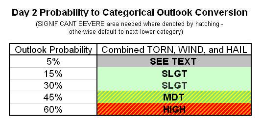
3.5 What do the outlook probabilities mean?
For the day-1 outlook graphics, the percentage lines enclose the chance
that the given type of severe weather (tornado, hail or damaging
thunderstorm wind) will happen within roughly a 25 mile radius of
any given point inside that line.
For Day-2 and Day-3, the probabilities cover all severe storm
hazards together.
Categorical (SLGT, MDT, HIGH) labels are tied directly to the
probability numbers as defined in
this table for Day-1,
in this table for Day-2
and this one for Day-3
outlooks.
3.6 Why do the probability values on the outlooks seem so low?
The probability values represent the chance of severe weather within about 25 miles of a point, which is about the size of a major metropolitan area.
Though severe storms tend to receive a large amount of media coverage, severe
weather is uncommon at any one location. Your chance of getting a tornado on any random day are very small, climatologically speaking. Put in that context, even a 10% chance of a tornado within 25 miles of a point means a much bigger threat than usual, and should be taken seriously. Think of how often tornadoes normally happen close to you on any given day, and those small-looking probabilities start to seem large by comparison!
3.7 What is that nameless brown line on Day-1 and Day-2 SPC outlook graphics?
The brown line is the general thunderstorm forecast line on the categorical outlook, and represents a 10% or greater probability of thunderstorms to the right of the line. We only do general thunder forecasts for Day-1 and Day-2 outlooks at this time, but may attempt day-3 general thunder forecasts on at least an experimental basis in the future.
4. Weather Questions (top)
4.1 How does the National Weather Service define severe weather?
There are many forms of hazardous, or severe weather. The primary mission
of the National Weather Service is to provide forecasts and warnings for the
protection of life and property. Forecasts can range from the climate
and seasonal outlooks for agricultural interests provided by the Climate
Prediction Center
(www.cpc.ncep.noaa.gov), to the daily county forecasts for the
public issued by local NWS offices. The NWS issues warnings for heavy snow,
freezing rain, high winds, flash flooding, river flooding, thunderstorms,
tornadoes, tropical storms, and hurricanes. In a broad sense, these are all
defined as severe weather as any of them can and do pose a threat to life
and property.
4.2 How does the National Weather Service (NWS) define a severe thunderstorm?
The term severe thunderstorm refers to a thunderstorm producing hail that is at least
penny size, 0.75 inches in diameter or larger, and/or wind gusts to 58 mph or
greater, and/or a tornado. Although lightning can be deadly, the NWS doesn't use it to define a severe thunderstorm. If it did,
every thnderstorm would be severe, by definition. Also, excessive rainfall may
lead to deadly flash flooding, but heavy rain is not a severe criterion either. The flood threat is handled through a separate set of watches and warnings from your lcoal NWS forecast office.
4.3 What is organized severe weather and why is it more important than
non-organized severe weather?
To some degree, all thunderstorms are organized. We refer to "organized"
severe storms as those which persist for several hours, are capable of multiple and/or significant severe weather events, and which we are able to
forecast consistently. The most long-lived, intense tornadoes and largest
hail are usually produced by supercell thunderstorms, while the most serious
convective wind storms are produced by bow echoes. The most serious severe
storms tend to form in areas where the vertical wind shear is relatively
strong and has particular characteristics, while shorter-lived storms
are most common when vertical wind shear is weak.
4.4 What environmental parameters are most often observed with organized
severe weather?
In general, severe thunderstorms form in areas where moisture, instability,
and lift are present. Additionally, long-lived severe thunderstorms are
often associated with strong vertical wind shear (e.g., winds that change
direction and increase in speed with height). Unfortunately, thunderstorm
initiation is not well-understood, and weather observations are too widely
spaced to detect all important small-scale features that influence storms.
4.5 Can you tell me what the weather
will be like on a specific date? or Is it going to rain today?
SPC doesn't produce local weather forecasts, and doesn't have the staffing
to handle individual forecast requests like this.
The SPC home page, along with the main page of any
other NWS center or office, will give you local forecasts by city,
state or ZIP code, using an entry box at upper left.
4.6 Do you have any educational information about lightning?
The National Severe Storms Lab has a great FAQ about lightning.
NWS Pueblo also provides some handy links to web resources on lightning.
4.7 Do you have any general information about thunderstorms?
NSSL also has a great FAQ about thunderstorms.
4.8 Can you give me details on a particular hailstorm, thunderstorm or tornado which hit on a certain date? Or can you tell me about hail or wind damage for the last 20 years in a certain place?
Unfortunately, no. We don't have the resources or staffing to fulfill every local
weather information request we receive. However, the National Climatic
Data Center (http://www.ncdc.noaa.gov,
phone 828-271-4800) does provide local weather event
information -- both in an interactive online website, and for severe
and extreme weather events, in a publication called Storm Data.
4.9 What is a derecho and where do I learn more about them?
A derecho is an exceptionally long-lived, widespread, severe, convective
wind outbreak.
Derecho producing storm systems also can contain tornadoes, but they
consist mostly of (and are defined by) damaging non-tornadic wind.
Sometimes a derecho results in hundreds of severe wind and damage
reports spread along a swath covering multiple states, with deaths,
injuries and many millions of dollars in losses.
See the SPC derecho FAQ
for more information and some historical examples.
4.10 Where can information be obtained on the occurrence of lightning from a past storm event?
The SPC does not maintain a database for past lightning strikes. While the NWS does not endorse any lightning vendors, there are numerous vendors of lightning detection systems and data (e.g., Vaisala's National Lightning Detection Network, WSI's U.S. Precision Lightning Network, Weather Decision Technology's Lightning Decision Support System). A complete list can be found at http://www.nws.noaa.gov/im/more.htm.
5. Tornado Questions(top)
5.1 What is a tornado?
This is the first question
in the tornado FAQ.
Please read the information there.
5.2 How many tornadoes and tornado deaths occur in a year?
Please see the Climatology section of the Tornado FAQ.
5.3 What is the Enhanced Fujita scale (EF-scale)?
Please see the
EF Scale discussion in the tornado FAQ
5.4 How many tornadoes occur in a year?
Please see the
Climatology section of the tornado FAQ
5.5 How does SPC forecast tornadoes?
Please see the Forecasting section
in the tornado FAQ.
5.6 Do you have some tornado safety tips?
Many issues of tornado safety are also covered in the Tornado FAQ
under its Safety section.
6. Other Questions (top)
6.1 Why did some severe weather not
show up on your reports list? How do I get a list of reports for
a particular place or perod of time?
The listings on the SPC Storms Reports page are
automatically collected from local storm reports (LSRs for short)
sent out by the local NWS offices.
If there was no LSR for an event, or it arrived a week or more late,
the report probably won't show up here.
Our storm reports list is preliminary and likely does not
contain all severe weather reports for any particular event.
Storm surveys may be needed to confirm tornadoes, EF scale, find
out if damage really was from a tornado or other thunderstorm winds, etc.
You can search Storm Data,
from the National Climatic Data Center, which provides the official,
final data for severe weather reports.
Storm Data takes a few months to compile, so if you need information
on more recent severe weather reports, please contact your
local NWS office.
6.2 Where is your lightning data page? How do I get lightning data?
We don't have a web page with lightning data. Unlike most weather data in the US, which is collected by the NWS and
paid for by tax dollars, "live" lightning data is completely privatized, meaning
companies collect and distribute it for a price. You won't find
it for free anywhere on the web unless the provider gives them a license
to do so. Lightning data (like you may see on TV weather reports) is
sold on contract by companies which gather the strike points through
sensors they have deployed around the country. NWS does get lightning data for
internal forecast use, but because it is locked in proprietary contract, it cannot be redistributed.
Commercial lightning data providers can be found using "lightning data" in a reputable Internet search engine.
6.3 Where can I get information on building a safe room in my house to help protect our family from tornadoes?
A structural engineer or contractor can help you plan a safe room or shelter
for your home. Helpful tips on getting started with safe rooms also are
provided by the Federal Emergency Management Agency.
6.4 What is NOAA Weather Radio and how can it help to protect me?
NOAA Weather Radio is a broadcast system which is available 24 hours a day that
continuously plays the latest warnings, watches, and forecasts. These radio
broadcasts can save your life in severe weather situations. For further
information please refer to
NOAA Weather Radio page.
6.5 How does someone become a
meteorologist (at the SPC or elsewhere)?
Usually, a Bachelor of Science (B.S.) degree in Meteorology is required to
enter the field and work as a forecaster. Some course work and experience can
also be gained in the military, especially the Navy and Air Force. Many
forecasters continue on to graduate school and acquire advanced
degrees (M.S. and PhD) in meteorology, atmospheric science, mathematics,
and computer science. Additional information about meteorology education can
be found on our Links page, and NSSL
maintains an online list of colleges providing meteorology degrees.
6.6 How can I get a job at the SPC
or in meteorology?
See
http://www.nssl.noaa.gov/faq/faq_careers.php
6.7 How can I become a professional storm chaser?
Very few people make a living as storm chasers. The vast majority of people
who chase storms do so as a hobby in their spare time, often at a cost of
hundreds or thousands of dollars a year. To become a professional storm
chaser, you must be able to consistently acquire and successfully
market your storm photographs and video. You may also develop enough skill
to have others pay to ride along with you on chases. However, it takes
many years to become a safe and successful storm chaser, and the market for
storm chase pictures/video and tours is quite competitive. The best way to
approach storm chasing is to ride along with more experienced chasers for
a few years, and practice severe storm forecasting at every opportunity.
6.8 How are the latitude and longitude
numbers expressed on the storm reports page and how can I depict this
information at mapquest.com or maps.google.com?
The lat/lon numbers are expressed in decimal degrees to two decimals.
For example, in the following report:
1108 75 NEODESHA WILSON KS 3742 9568 (ICT)
the latitude is 37.42 (or 37.42N) and longitude is 95.68 (or -95.68W)
The latitude values are referenced as North, and the longitude values are
referenced as West and negative.
The negative signs are included in the comma separated values (CSV) files
for the ease of importing into other mapping programs.
A lat/lon interface at mapquest.com:
http://atlas.mapquest.com/maps/latlong.adp
Similar lat/lon interface at maps.google.com:
http://maps.google.com/
6.9 What are the 3-letter IDs in the Storm Reports Comment section?
The 3-letter IDs represent the reporting WFO office for the report. For example,
NICKEL TO QUARTER SIZED HAIL...STRONG WINDS WITH POWER OUTAGES AND VERY HEAVY RAIN. (OAX)
The report above was from (OAX) which is Omaha, NE WFO.
Follow this link to see a list of all WFO IDs and Locations.
More unanswered questions?
Post your questions on the Feedback page.
Acknowledgments:Current and past contributors to this FAQ
(alphabetically) include Greg Carbin, Roger Edwards, Greg Grosshans,
David Imy, Mike Kay, Jay Liang, Joe Schaefer and Rich Thompson.
In addition to them, Jared Guyer has answered a good deal of e-mail
questions through our feedback service.
|


