
NOAA Satellites Primed for Spike in Summer Distress Calls
June 4, 2008

As the heat of summer lures more boaters, campers and hikers to the great outdoors, NOAA satellites are primed for an inevitable spike in distress signals from emergency locator beacons.
Through May, 139 people have been rescued in the United States this year. In 2007, a record 353 people were rescued from potentially life-threatening emergencies thanks to NOAA’s polar-orbiting and geostationary satellites, which form part of the international Search and Rescue Satellite-Aided Tracking System, called COSPAS-SARSAT.
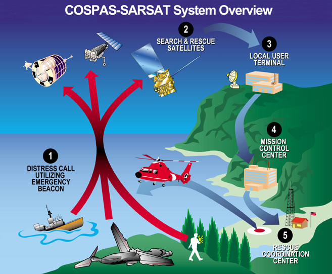
This high-tech system uses a network of satellites to quickly detect and locate distress signals from emergency beacons onboard aircraft, boats and from the handheld personal locator beacons. Now in its 26th year of operation, COSPAS-SARSAT has been credited with more than 23,000 rescues worldwide, including nearly 6,000 in the United States and its surrounding waters.
SARSAT statistics show a significant increase in rescues during the spring and summer seasons compared to colder weather months:
- In 2007, 87 rescues were made in the United States between January and March, but 111 people were saved between June and August.
- In 2003, 24 rescues occurred between January and March, but during the June – August period that number quadrupled to 96 lives saved.
“During the summer, we typically see a big jump in rescues because more people are out enjoying the warm weather,” said Chris O’Connors, program manager for NOAA-SARSAT. “But anyone planning to hike or camp this summer in a remote area where cell phone service is not reliable, or sail a boat far from shore, should not leave home without an emergency beacon registered with NOAA.”
When a satellite pinpoints a distress location within the United States, or its surrounding waters, the information is relayed to the SARSAT Mission Control Center at NOAA’s Satellite Operations Facility in Suitland, Md. The information is then sent to a Rescue Coordination Center, operated either by the U.S. Air Force, for land rescues, or the U.S. Coast Guard, for maritime rescues.
Older emergency beacons, which operate on the 121.5 and 243 megahertz (MHz) frequencies, will be phased out by February 1, 2009. That’s when 406 MHz beacons will become the new standard. Key reasons for the switchover include the ability of the 406 MHz beacons to be detected instantly; they are more accurate, and provide Search and Rescue responders with important registration information -- features the older beacons do not offer.
“We are encouraging all 121.5 MHz beacon owners to make the switch to 406 now, so their distress signals will always be answered,” said NOAA Corps Lt. Jeffrey Shoup, who is the support officer for SARSAT operations.
Shoup added, “There have already been a handful of aviation rescues this year attributed to the 121.5 frequency beacons, mostly in Alaska, but after February 1, such rescues by the SARSAT system will no longer be the case.”
The National Oceanic and Atmospheric Administration, an agency of the U.S. Commerce Department, is dedicated to enhancing economic security and national safety through the prediction and research of weather and climate-related events and information service delivery for transportation, and by providing environmental stewardship of our nation's coastal and marine resources. Through the emerging Global Earth Observation System of Systems (GEOSS), NOAA is working with its federal partners, more than 70 countries and the European Commission to develop a global monitoring network that is as integrated as the planet it observes, predicts and protects.