Bret was a small hurricane that made landfall along a sparsely-populated
section of the south Texas coast with sustained winds up to 100 knots.
Bret was the first hurricane to strike the Texas coast since Hurricane
Jerry in October 1989. It was the first hurricane to affect south Texas
since Hurricane Allen in August 1980, and it was the strongest since
Hurricane Alicia in 1983.
a. Synoptic History
Bret formed as a tropical depression over the Bay of Campeche on 18 August.
Both a tropical wave and an upper-level low contributed to the formation of
Bret. A tropical wave moved from Africa to the tropical Atlantic Ocean on 5
August. Continuity and soundings from Merida, Mexico place this weak
tropical wave in the vicinity of the Yucatan Peninsula on the 18th.
The second feature, an upper-level cyclonic circulation, appeared on water
vapor imagery over the north central Caribbean moving westward on 15 August.
The circulation initiated a thunderstorm complex on the night of the
17th over the Yucatan Peninsula and a weak surface low formed in
the same location early on the 18th..
Later on the 18th, the surface low moved over the Bay of Campeche.
Early morning visible satellite imagery showed a low level cloud circulation
center and, a few hours later, a U.S. Air Force Reserve Unit reconnaissance
mission confirmed the existence of a closed circulation. With some deep
convection and banding present, the system was upgraded to a tropical
depression at 1800 UTC on the 18th over the Bay of Campeche.
The best track begins at this time, as shown in
Table 1, which is a listing of Bret's best track
positions, wind speeds, and central pressures, every six hours.
Figure 1 shows a map of this track.
The depression did not strengthen right away due to vertical shear caused by
an upper-level trough over the extreme western Gulf of Mexico. But the
trough moved away and Bret reached tropical storm strength late on the
19th while beginning to move slowly northward. The vertical
shear decreased. Bret rapidly became more organized and then steadily
strengthened to a 125-knot category four hurricane on the Saffir/Simpson
scale on the morning of the 22nd, while appproaching south Texas coast near
Brownsville. Responding to the presence of a weak mid-tropospheric ridge
over the northwest Gulf of Mexico and to a mid-tropospheric cyclonic
circulation over the Rio Grande valley, Bret turned northwestward and slowed
its forward speed down to about 5 knots. The forward speed had earlier been
as high as 9 knots.
Bret's center crossed the Texas coast over the central portion of Padre
Island, midway between Brownsville and Corpus Christi, at 0000 UTC, 23
August. It had weakened to a category three hurricane with 100 knot winds
and a pressure of 951mb by the time of landfall. After moving inland,
Bret's movement became more westward with a slow forward speed. Bret
continued to weaken as it moved across south Texas and into the
high terrain of north central Mexico where it dissipated on the
25th.
b. Meteorological Statistics
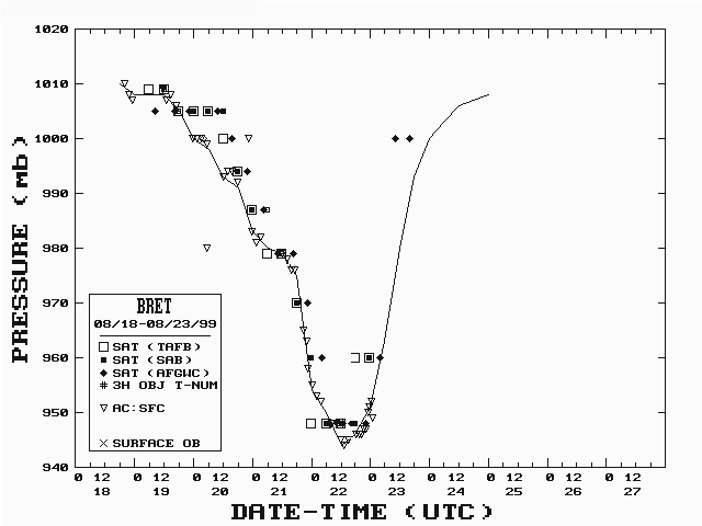
Figure 2 and Figure 3 depict the
best track curves and data plots of the
maximum sustained 1-min surface winds (10m above ground level) and minimum
central pressure, respectively, as a function of time. These plots include
data gathered by aircraft reconnaissance and Dvorak satellite classification
estimates and an occasional ship or land report.
Aircraft reconnaissance coverage began at 2000 UTC 18 August and continued
until just after the hurricane's landfall at 0100 UTC 23 August. The
maximum 1-min surface wind speed of 125 knots at 0600 and 1200 UTC on the
22nd is based on GPS-sonde vertical wind speed profiles.
Figure 4
shows one of these profiles and shows that winds reached near 150 knots
within 1000 feet (300 meters) above the surface and were near 125 knots near
the surface. Bret's pressure dropped 35 millibars to 944 millibars in the
24 hours ending at 1200 UTC on the 22nd and dropped 21 millibars in
the six hours ending at 0000 UTC of the same day.
This episode of intensification coincides with the hurricane's track over a
maximum in the sea surface temperature (SST) field over the west central
Gulf of Mexico. Analyses from the Johns Hopkins University Applied Physics
Laboratory shows 31C SST values along Bret's track during
this intensification period. In addition, estimates of the upper oceanic
heat content (described by Shay et al., 1999) under
portions of the hurricane's circulation in the western Gulf of Mexico were
rather high.
During the 12 hours prior to landfall, the hurricane weakened from 125 to
100 knots. It was also at this time that the western edge of the eyewall
was coming into contact with Padre Island.
Bret was a small hurricane. At its peak, hurricane force winds were
confined to a narrow radius of 30-40 miles from the center in the north
semicircle and only 10-20 miles in the south semicircle. Thus only a small
segment of the Texas coast was affected by the core of the hurricane.
Kennedy County received most of the hurricane force winds which are
estimated as high as 100 knots over a small portion of the coast of Padre
Island. With the center moving inland over a sparsely populated area, few
surface reports were available substantiating strong winds. Table 2 lists a
selection of available surface observations, provided by the National
Weather Service offices at Brownsville, Corpus Christi, and
Houston/Galveston. The highest reported sustained wind in Table 2 is 63
knots at Rincon del San Jose on Padre Island. The instrument
there failed at 2230 UTC on the 22nd just before the center passed
close by.
The Port Aransas C-MAN station reported maximum sustained winds of 41 knots
as the center of the hurricane passed about 60 n mi to the south.
Bret was slow moving and Doppler radar estimates suggest maximum storm total
precipitation amounts of over 30 inches in Kennedy county. None of the
rainfall totals in Table 2 come close to that value.
Aransas Pass is north
of the area of peak rainfall and it reported a storm total of 12.60 inches.
The heavy rains accompanying the weakening tropical cyclone caused notable
river flooding in the Rio Grande Valley. The Rio Grande River at Laredo and
the Aransas River near Skidmore and at Oso Creek crested slightly above
flood stage, causing local flooding in these respective areas.
A 24-hour rainfall total of over 14 inches was reported from the Mexican
state of Nuevo Leon and the state of Tamaulipas is believed to have received
similar rainfall.
Theoretical values from the SLOSH storm surge model indicate that a narrow
region along Central and North Padre Island had a storm surge of 8 to 10
feet. A report from Port Mansfield Pass suggests that three to five feet of
water penetrated this coastal location. Several cuts were observed in the
dunes surrounding Padre Island. The largest of these, near mile marker 50
near the eye's passage, was mistaken by aircrews inspecting the damage as
the Mansfield Pass. Substantial beach erosion was reported near Port
Mansfield.
In Aransas County around 2145 UTC 22 August, a tornado reportedly destroyed
a recreational vehicle, along with a barn and a shed, and uprooted trees.
Other reports indicate that a tornado touched down in Kingsville around 2245
UTC on the 22nd and a tornado was reported in Alice, time unknown.
Little damage was reported with the latter two.
c. Casualty and Damage Statistics
Despite Bret's intensity, damage was generally reported to be fairly light.
Much of this owed to its landfall over a sparsely populated region in south
Texas and its small size. The nearest population centers, Brownsville and
Corpus Christi, were spared the brunt of the hurricane's core.
Property insurance damage claims total 30 million dollars as reported by the
Property Claims Services Division of the Insurance Services Office.
Multiplying by a factor of 2.0 gives an estimated damage total of 60 million
dollars.
There have been no reports of loss of life.
d. Forecast and Warning Critique
The average forecast track errors for Bret are as follows: 65 n mi at 24
hours, 155 n mi at 48 hours, and 255 n mi (5 cases) at 72 hours. These
values are just slightly below the previous 10-year averages. The GFDL
model had a left bias and brought the hurricane inland over Mexico on a
northwest to westward track for several forecasts as Bret moved northward.
It has been suggested that the use of high-resolution topography with
18,000-feet mountains over Mexico in the GFDL model is the reason for the
left bias.
The official forecast issued at 1800 UTC on the 19th,
when Bret first became a tropical storm, had a 72-hour wind speed error of
-85 knots. This was caused by the GFDL bias and resultant official forecast
which placed the storm inland in 72 hours, rather than strengthening in the
Gulf of Mexico.
References
Shay, L. K., G. J. Gustavo, J. Goni, and P. G. Black, 1999: Effects of a
warm oceanic feature on Huricane Opal. Accepted for publication in
Mon.Wea.Rev.
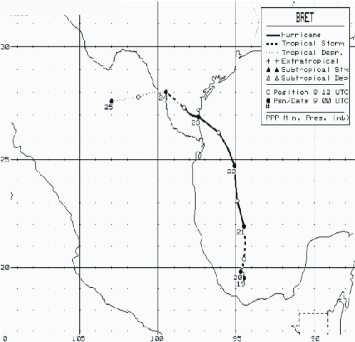
Figure 1.
Best track positions for Hurricane Bret, 18-25 August 1999.

Figure 2.
Best track maximum sustained wind speed curve for Hurricane Bret.

Figure 3.
Best track minimum central pressure curve for Hurricane Bret.
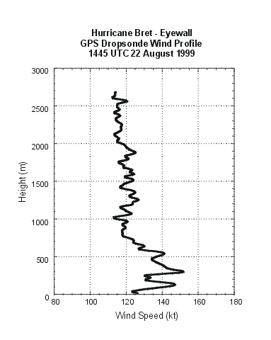
Figure 4.
GPS Dropsonde vertical wind speed profile for Hurricane Bret.
Table 1.
Preliminary Best Track - Hurricane Bret, 18-25 August, 1999.
Date/Time
(UTC) | Position |
Pressure
(mb) |
Wind Speed
(kt) | Stage |
| Lat. (°N) | Lon. (°W) |
| 18/1800 | 19.5 | 94.4 | 1010 | 30 | tropical depression |
| 19/0000 | 19.5 | 94.5 | 1008 | 30 | " |
| 0600 | 19.6 | 94.6 | 1008 | 30 | " |
| 1200 | 19.7 | 94.6 | 1008 | 30 | " |
| 1800 | 19.8 | 94.7 | 1005 | 35 | tropical storm |
| 20/0000 | 19.8 | 94.7 | 1000 | 40 | " |
| 0600 | 20.0 | 94.6 | 998 | 45 | " |
| 1200 | 20.4 | 94.5 | 993 | 50 | " |
| 1800 | 21.2 | 94.4 | 991 | 55 | " |
| 21/0000 | 21.9 | 94.5 | 983 | 65 | hurricane |
| 0600 | 22.5 | 94.7 | 980 | 75 | " |
| 1200 | 23.1 | 94.9 | 979 | 80 | " |
| 1800 | 23.8 | 95.0 | 975 | 90 | " |
| 22/0000 | 24.7 | 95.1 | 954 | 120 | " |
| 0600 | 25.5 | 95.5 | 950 | 125 | " |
| 1200 | 26.2 | 96.1 | 944 | 125 | " |
| 1800 | 26.6 | 96.8 | 946 | 120 | " |
| 23/0000 | 26.9 | 97.4 | 951 | 100 | " |
| 0600 | 27.0 | 97.9 | 963 | 80 | " |
| 1200 | 27.3 | 98.3 | 980 | 60 | tropical storm |
| 1800 | 27.6 | 98.8 | 993 | 35 | " |
| 24/0000 | 28.0 | 99.5 | 1000 | 30 | tropical depression |
| 0600 | 28.0 | 100.4 | 1003 | 30 | " |
| 1200 | 27,8 | 101.3 | 1006 | 25 | " |
| 1800 | 27.7 | 102.1 | 1007 | 25 | " |
| 25/0000 | 27.6 | 103.0 | 1008 | 20 | " |
| 0600 | | dissipated |
| |
| 22/1200 | 26.2 | 96.1 | 944 | 125 | minimum pressure |
|---|
| 23/0000 | 26.9 | 97.4 | 951 | 100 | landfall at central Padre Island, Texas |
|---|
Table 2. Hurricane Bret selected surface observations, August 1999.
| |
Minimum
sea-level
pressure |
Maximum surface wind speed
(kt) |
|
| Location |
Press.
(mb) |
Date/
time
(UTC) |
Sust.
winda
(kts) |
Peak
gust (kts) |
Date/
timeb
(UTC) |
Storm
surgec
(ft) |
Storm
tided
(ft) |
Rain
(storm total)
(in) |
| Texas |
| Brownsville Airport ASOS | 1002.4 | 22/2131 | 29 | 47 | 22/1830 | | | 1.99 |
| Cameron City Airport ASOS | 999.7 | 22/2035 | 36 | 46 | 22/1841 | | | 3.49 |
| Harlingen Airport ASOS | 999.0 | 22/2310 | 38 | 48 | 22/2208 | | | 2.55 |
| Port Isabel | | | | | | 1.1 | | |
| McAllen Airport ASOS | 1003.1 | 23/0023 | 28 | 37 | 22/2209 | | | 2.93 |
| South Padre Island | 998.6 | 22/1815 | 38 | 48 | 22/1915 | | | 3.88 |
| Arroyo Colorado | | | 43 | 57 | 22/1900 | | | |
| Port Mansfield | 985.4 | 22/2000 | 42 | 66 | 22/2200 | | | |
| Rincon del San Jose | | | 63* | 78* | 22/2230 | | | |
| Falfurrias Airport | 976.6 | 22/0330 | | 85* | 23/0330 | | | |
| Edinburg | | | | | | | | 3.41 |
| El Sauz | | | | | | | | 2.00 |
| Falcon | | | | | | | | 1.19 |
| Garciasville | | | | | | | | 2.72 |
| Harlingen | | | | | | | | 2.94 |
| Hebbronville | | | | | | | | 4.57 |
| Laguna Atascosa | | | | | | | | 4.16 |
| La Joya | | | | | | | | 4.65 |
| Los Fresnos | | | | | | | | 2.56 |
| McAllen | | | | | | | | 3.10 |
| Mercedes | | | | | | | | 1.02 |
| Monte Alto | | | | | | | | 4.06 |
| Rancho Viejo | | | | | | | | 1.45 |
| Raymondville | | | | | | | | 3.07 |
| Rincon | | | | | | | | 1.80# |
| Rio Grande City | | | | | | | | 4.14 |
| Santa Ana NWR | | | | | | | | 3.82 |
| Santa Rosa | | | | | | | | 3.54 |
| Sarita(Kenedy Co.) County co | | | | | | | | 13.18 |
| Weslaco | | | | | | | | 6.84 |
| Zapata | | | | | | | | 2.48 |
| Bob Hall Pier | | | | | | | 2,6 | |
| Corpus Christi | 1002.4 | 23/0322 | 39 | 48 | 23/0326 | | | 5.18 |
| Kingsville NAS ASOS | 1001.7 | | 35 | 44 | 22/1843 | | | 3.09 |
| Rockport ASOS | 1006.4 | 22/2228 | 34 | 41 | 23/1506 | | 1.8 | 2.29 |
| Victoria ASOS | 1008.8 | 23/0900 | 22 | 28 | 24/1811 | | | 0.69 |
| Alice ASOS | 998.3 | 23/1217 | 39 | 48 | 23/1748 | | | 3.97 |
| Cotulla ASOS | 1006.4 | 23/1753 | 33 | 40 | 23/2332 | | | 4.27 |
| McMullen Target ASOS | | | 38 | | 22/2124 | | | |
| Port Aransas C-MAN | 1003.1 | 22/2200 | 41 | 52 | 23/2200 | | | |
| Aransas Pass | | | | 57 | 23/2115 | | | 12.60 |
| Freer | | | | | | | | 2.68 |
| Benavides | | | | | | | | 5.10 |
| Calliham | | | | | | | | 2.00 |
| Concepcion | | | | | | | | 7.38# |
| Fowlerton | | | | | | | | 4.07 |
| George West | | | | | | | | 5.30 |
| Point Comfort | | | | | | | | 0.21# |
| Portland | | | | | | | | 7.95 |
| Robstown | | | | | | | | 5.36# |
| Sinton | | | | | | | | 5.46 |
| Victoria CP&L | | | | | | | | 0.52 |
| Alice | | | | | | | | 3.00 |
| Buoy 42019 | 1007. | 22/2200 | 37 | | 23/1600 | | | |
| Buoy 42020 | 982.9 | 22/1900 | 58 | 73 | 22/1900 | | | |
| Freeport | | | | | | | 2.4 | |
| Palacios ASOS | 1008. | 23/0353 | 23 | 27 | 22/1012 | | | 0.42 |
| Galveston ASOS | 1010. | 23/0425 | 19 | 22 | 23/1032 | | | 0.02 |
| Angleton/L. Jackson ASOS | 1010. | 23/0602 | 20 | 26 | | | | 0.26 |
aNWS ASOS and C-MAN averaging periods are 2 min; buoys are 8 min.
bDate/time is for sustained wind when both sustained and gust are listed.
cStorm surge is water height above normal astronomical tide level.
dStorm tide is water height above NGVD.
eEstimated.
*Equipment failed or power outage experienced.
#24-hour rainfall total.
Table 3.
Watch and warning summary, Hurricane Bret, 18-25 August, 1999.
Date/time
(UTC) |
Action |
Location |
| 19/2100 | Tropical Storm Warning issued | Tampico to Coatzacoalcos, Mexico |
| 20/1500 | Hurricane Watch and Tropical Storm Warning issued | La Pesca to Veracruz, Mexico |
| 20/1500 | Tropical Storm Warning discontinued | Veracruz to Coatzacoalcos, Mexico |
| 21/0900 | Hurricane Watch issued | Tuxpan, Mexico to Baffin Bay Texas |
| 21/0900 | Hurricane Watch/Tropical Storm Warning discontinued | Tuxpan to Vera Cruz, Mexico |
| 21/1500 | Hurricane Warning issued | La Pesca, Mexico to Baffin Bay, Texas |
| 21/2100 | Hurricane Watch/Tropical Storm Warning issued | Baffin Bay to Port Aransas, Texas |
| 22/0300 | Hurricane Warning issued | Baffin Bay to Port O'Connor, Texas |
| 22/0300 | Hurricane Watch/Tropical Storm Warning issued | Port O'Connor to Freeport, Texas |
| 22/0900 | Hurricane Watch discontinued | Tuxpan to Tampico, Mexico |
| 22/1500 | Hurricane Watch discontinued | Tampico to La Pesca, Mexico |
| 22/2100 | Hurricane Watch discontinued | Port O'Connor to Freeport, Texas |
| 23/0100 | Hurricane Warning discontinued | La Pesca to U.S./Mexican border |
| 23/0300 | Hurricane Warning downgraded to Tropical Storm Warning | north of Port Aransas to Port O'Connor, Texas |
| 23/0300 | Tropical Storm Warning discontinued | north of Port O'Connor to Freeport, Texas |
| 23/0900 | Hurricane Warning downgraded to Tropical Storm Warning | Brownsville to Port Aransas, Texas |
| 23/2100 | Tropical Storm Warning discontinued | Brownsville to Port Aransas, Texas |
![[NCEP Logo]](graphics/ncep.gif)