
NOAA Research Home » Outstanding Papers
NOAA Research 2007 Outstanding Scientific Paper Awards
“Flooding on California’s Russian River: Role of atmospheric rivers”
ABSTRACT
Experimental observations collected during meteorological field studies conducted
by the National Oceanic and Atmospheric Administration near the Russian River
of coastal northern California are combined with SSM/I satellite observations
offshore to examine the role of landfalling atmospheric rivers in the creation
of flooding. While recent studies have documented the characteristics and
importance of narrow regions of strong meridional water vapor transport over
the eastern Pacific Ocean (recently referred to as atmospheric rivers), this
study describes their impact when they strike the U.S. West Coast. A detailed
case study is presented, along with an assessment of all 7 floods on the
Russian River since the experimental data were first available in October
1997. In all 7 floods, atmospheric river conditions were present and caused
heavy rainfall through orographic precipitation. Not only do atmospheric
rivers play a crucial role in the global water budget, they can also lead
to heavy coastal rainfall and flooding, and thus represent a key phenomenon
linking weather and climate. FULL
TEXT ![]()
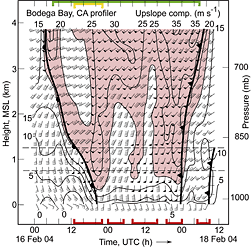
Time-height section of hourly averaged wind profiles, upslope-component isotachs (m s-1, directed from 230°; >20 m s-1 red-shaded), and fronts at BBY on 16– 18 February 2004 (wind flags = 25 m s-1, barbs = 5 m s-1, half-barbs = 2.5 m s-1). Colored brackets denote the following observations at BBY: red = LLJ episodes; green = IWV > 2 cm; yellow = IWV > 3 cm. Data within the pair of dashed lines (750–1250 m MSL) were layer-averaged and presented in Figure 3. (larger image)
Composite SSM/I satellite image of IWV (cm; color bar at bottom) constructed from polar-orbiting swaths between ∼1400 and 1830 UTC 16 February 2004, and ranking of daily streamflows (percent; see inset key) on 17 February 2004 for those gauges that have recorded data for ≥30 years. The streamflow data are based on local time (add 8 h to convert to UTC. (larger image)
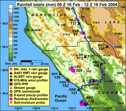
Terrain base map of northern California’s Russian River watershed showing the locations of the observing systems (see key). The three-letter station names are given for the experimental sites. The numerical values represent the 60-h accumulated rainfall between 0000 UTC 16 February and 1200 UTC 18 February 2004. (larger image)
NOAA Research Home » Outstanding Papers
CLIMATE · OCEANS,
GREAT LAKES, and COASTS · WEATHER
and AIR QUALITY
ABOUT US · RESEARCH
PROGRAMS · EDUCATION · HOME
10/22/07