Detecting Tornadoes
What does a tornadic storm look like?
Forecasters and storm spotters have learned to recognize certain thunderstorm features and structure that make tornado formation more likely. Some of these are visual cues, like the rear-flank downdraft, and others are particular patterns in radar images, like the tornadic vortex signature (TVS).

VISUAL EVIDENCE
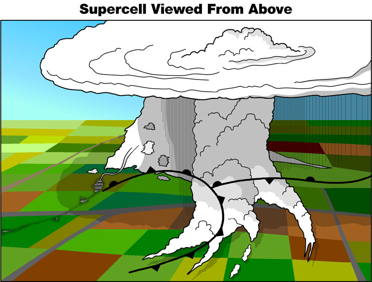
The most reliable evidence of a tornado is for someone who has been trained to recognize tornadoes to actually see one. Storm spotters report what they see to the National Weather Service and provide important information to warning forecasters who must make critical warning decisions. Storm spotters can be emergency managers or even local people with a keen interest in severe weather who have undergone formal storm spotter training in their community. Some of the features storm spotters and forecasters look for in tornadic storms include:
- Inflow Bands
Inflow bands are ragged bands of low cumulus clouds extending from the main storm tower to the southeast or south. The presence of inflow bands suggests that the storm is gathering low-level air from several miles away. If the inflow bands have a spiraling nature to them, it suggests the presence of rotation. - Beaver's tail
The beaver's tail is a smooth, flat cloud band extending from the eastern edge of the rain-free base to the east or northeast. It usually skirts around the southern edge of the precipitation area. It also suggests the presence of rotation. - Wall Cloud
A wall cloud is an isolated cloud lowering attached to the rain-free base of the thunderstorm. The wall cloud is usually to the rear of the visible precipitation area. Wall clouds are about two miles in diameter and mark the area of strongest updraft in the storm.
As the storm intensifies, the updraft draws in low-level air from several miles around. Some low-level air is pulled into the updraft from the rain area. This rain-cooled air is very humid; the moisture in the rain-cooled air quickly condenses below the rain-free base to form the wall cloud.
A wall cloud that may produce a tornado usually exists for 10-20 minutes before a tornado appears. A wall cloud may also persistently rotate (often visibly), have strong surface winds flowing into it, and may have rapid vertical motion indicated by small cloud elements quickly rising into the rain-free base. - Rear Flank Downdraft
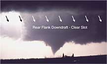
The rear flank downdraft is a downward rush of air on the back side of the storm that descends along with the tornado. The RFD looks like a "clear slot" or "bright slot" just to the rear (southwest) of the wall cloud. It can also look like curtains of rain wrapping around the cloud base circulation. Eventually, the tornado and RFD will reach the ground within a few minutes of each other. The RFD causes gusty surface winds that occasionally have embedded downbursts The rear flank downdraft is the motion in the storm that causes the hook echo feature on radar.
larger image - Condensation funnel
A condensation funnel is made up of water droplets and extends downward from the base of the thunderstorm. If it is In contact with the ground it is a tornado; otherwise it is a funnel cloud. Dust and debris beneath the condensation funnel confirm a tornado's presence.
RADAR EVIDENCE
A tornadic storm observed by radar also has certain distinguishing features. Computer programs, called algorithms, analyze Doppler radar data and display it in ways that make it easier to identify dangerous weather. Forecasters are trained to recognize the precise radar signatures produced automatically by these sophisticated computer applications. Today's weather radars typically provide on average 11 minutes lead-time, and can pinpoint locations directly in harm's way with a high degree of accuracy. Some of the radar features forecasters look for Include:
- Mesocyclone
- Tornadic Vortex Signature
- Hook Echo
The next generation of weather radars is now being developed. Scientists are adapting phased array technology, currently used on Navy ships, for use in weather forecasting. Phased array technology is expected to lengthen the average lead time for tornado warnings from 12 minutes to 20 minutes.
Other computer programs, like the Advanced Weather Interactive Processing System (AWIPS) used in all forecast offices, identify different kinds of severe weather, including tornadoes, using the latest observational data from Doppler radars, surface and upper air observing systems, mesoscale numerical models, satellites, and the National Lightning Detection Network. These computer applications incorporate image recognition, artificial intelligence, data mining, and statistical methods and couple them with state-of-the-art display platforms.
HOW DOES NSSL CONTRIBUTE?
Radar Development
NSSL built the first real-time displays of Doppler velocity data. This
lead to an NSSL scientist's discovery of the Tornadic Vortex Signature
in radar velocity data in the 1970's. These developments helped spur deployment
of the WSR-88D NEXRAD radar network. The Department of Commerce recognized
NSSL's contribution to the NEXRAD program and to our Nation by awarding
a Gold Medal to NSSL.
NSSL made the first observations of a tornadic storm with two Doppler radars (called dual-Doppler). The radars were located about 40 miles from each other and were able to record data on the same storm but from two different perspectives. The data was used to map the structure of a tornadic storm at several altitudes.
Airborne Doppler
NSSL continues to refine the use of airborne Doppler
radar (installed on NOAA's P-3 research aircraft) to study storms. The
first direct measurements of a tornado recorded with an airborne Doppler
radar were made by NSSL. New concepts of making dual-Doppler
measurements using the WSR-88D with the airborne Doppler were first
tested in 1989 and are now used routinely.
Mobile Doppler Radars
NSSL collaborated with the University of Oklahoma,
Texas Tech and Texas A&M University to build the Shared Mobile Atmospheric
Research and Teaching-Radars, two 5-cm wavelength mobile Doppler radars than
can scan and penetrate through an entire tornado or hurricane. The SMART-Radars will
be used to study convective and mesoscale atmospheric processes to help improve
forecasts of significant weather events.
Dual-polarization
Engineers at NSSL developed polarimetric technology for the NEXRAD Doppler
radar network. A polarized radar has the ability to measure reflected power
returned to the radar from both horizontal and vertical pulses. Scientists
recently discovered polarimetric signatures aloft that might be related
to a developing tornado.
WDSS-II
NSSL's second generation Warning Decision Support System, WDSS-II,
is an advanced algorithm development and visualization platform that accepts
data from multiple sources and organizes it in ways that convey critical
severe weather information to warning meteorologists.
NSSL developed the Tornado Detection Algorithm now used by the National Weather Service in their forecasting operations.
Phased Array
The National Weather Radar Testbed at NSSL, constructed in 2003, is where
the next generation of weather radars is being developed. NSSL engineers
and scientists are adapting phased array technology, currently used on
Navy ships, for use in weather forecasting. Phased array technology is
expected to lengthen the average lead time for tornado warnings from 11
minutes to 20 minutes.
OK-WARN
The Oklahoma Weather Alert
Remote Notification program provides deaf and hard-of-hearing Oklahoman's
access to emergency severe weather information via alphanumeric pagers
and/or E-mail addresses. NSSL scientist Vincent Wood received the Department
of Commerce Gold Medal award for his part in developing
this hazardous weather pager program.