National Hurricane Center Forecast Verification
Updated 21 May 2008
Contents
- Introduction
- Forecast verification procedures
- Annual NHC verification reports
- Official five-year mean errors and distributions
- Official error trends
- Model error trends
- NHC official forecast error database
- Performance measures and goals
- References
4. Official five-year mean errors and distributions
Due to the natural volatility in tropical cyclone track characteristics,
annual errors can vary significantly from year to year. For example, years
dominated by tracks through the low latitude easterly trade winds typically
have relatively small annual errors. Conversely, a relatively large number
of forecasts in the mid-latitude westerlies (as can occur during El Niño
years) can lead to larger errors. Consequently, representative or stable
error characteristics must be obtained using a longer period of record.
Traditionally, NHC has
considered 10 years to be a representative period of
record, however, there are now reasons to use a shorter period.
Because of the significant reduction in track error that has
occurred in recent years, 10-year averages no longer reflect the
current state of the art. Further, the increase in tropical
cyclone activity in the Atlantic basin allows for more stable
statistics over shorter periods. Therefore,
NHC is now using a 5-year sample to define its long-term forecast error
characteristics. Average errors for the last 5 period are given
below. These verifications follow the procedures given above in
Section 2 (i.e.,
they include the subtropical and depression stages) and the sample is
homogeneous with the operational CLIPER5 and Decay-SHIFOR5 models.
Mean official track and intensity forecast errors for the 5-year period 2003-2007 (.pdf)
The
distributions of 5-year track and intensity errors are given graphically in the
figures below.
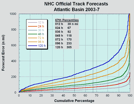 Cumulative distribution of five-year official Atlantic basin tropical cyclone track forecast errors.
Diagram shows the percentage of official forecasts having
an error less than the value along the y-axis. For example, to determine the fraction of 24
h forecasts having an error smaller than 100 n mi, find 100 n mi on the y-axis, and read
across the diagram until this value intersects the red (24 h forecast) line. Then read down
to obtain the percentage.
These track error
distributions are used to set the size of the "forecast error cone" displayed
on NHC track forecast web graphics. In these graphics, the cone represents the probable track of the
center of a tropical cyclone, and is formed by enclosing the area swept out by
a set of circles along the forecast track (at 12, 24, 36 hours,
etc). The size of each circle is set so that two-thirds (67%) of historical
official forecast errors over a 5-year sample fall within the circle. The
circle radii defining the error cone in 2008 for the Atlantic
basin are given in the figure above.
 Cumulative distribution of five-year official Atlantic basin tropical cyclone intensity forecast errors.
Diagram shows the percentage of official forecasts
having an error magnitude less than the value along the y-axis. For example, to
determine the fraction of 24 h forecasts having an error smaller than 20 kt, find 20 kt on
the y-axis, and read across the diagram until this value intersects the red (24 h forecast)
line. Then read down to obtain the percentage.
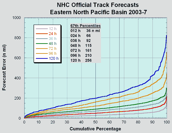 Cumulative distribution of five-year official eastern North Pacific basin tropical cyclone track forecast errors.
Diagram shows the percentage of official forecasts having an error less
than the value along the y-axis. For example, to determine the fraction
of 24 h forecasts having an error smaller than 100 n mi, find 100 n mi
on the y-axis, and read across the diagram until this value intersects
the red (24 h forecast) line. Then read down to obtain the percentage. The size of the cirlcles defining the
forecast error cone in 2008 for the eastern North Pacific basin are
given in the figure above.
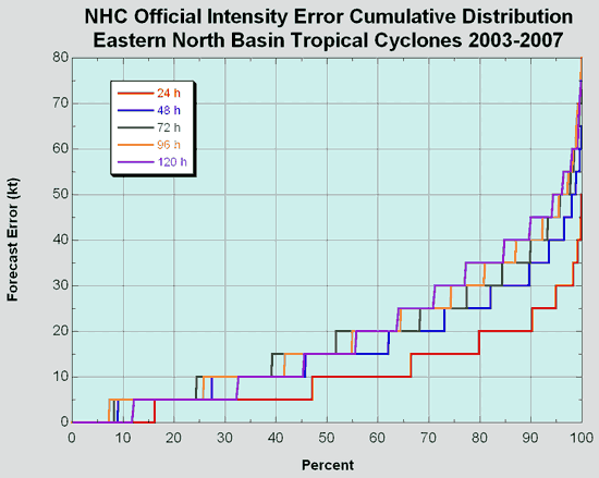
Cumulative distribution of five-year official eastern North Pacific basin tropical cyclone intensity
forecast errors.
Diagram shows the percentage of official
forecasts having an error magnitude less than the value along the y-axis. For example, to
determine the fraction of 24 h forecasts having an error smaller than 20 kt, find 20 kt on
the y-axis, and read across the diagram until this value intersects the red (24 h forecast)
line. Then read down to obtain the percentage.
Next: Official error trends
|


 Cumulative distribution of five-year official Atlantic basin tropical cyclone track forecast errors.
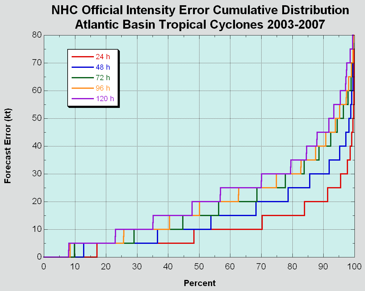 Cumulative distribution of five-year official Atlantic basin tropical cyclone intensity forecast errors.
 Cumulative distribution of five-year official eastern North Pacific basin tropical cyclone track forecast errors.