Figure 1.
Detailed track of Irene showing the landfall points and a GOES 8 visible
satellite image at the time of landfall near Flamingo, Florida.
a. Synoptic History
A broad area of low pressure prevailed over the southwestern Caribbean from
the 8th to the 10th of October, accompanied by
disorganized clouds and thunderstorms. This system did not show signs of
tropical cyclone development until a tropical wave reached the western
Caribbean Sea on 11 October. On the 12th, a U.S. Air Force
Reserve reconnaissance plane was dispatched to the region and found an
incipient low-level circulation and a broad low pressure area of 1006 mb
just to the northeast of the coast of Honduras. However, the circulation
was too disorganized to be classified as a tropical depression. Satellite
imagery during the night showed that the thunderstorm activity increased and
both banding features and upper-level outflow became quite distinct. Post
-analysis of surface and upper-air data from Grand Cayman, and satellite
Dvorak T-numbers indicate that Tropical Depression Thirteen formed in the
northwestern Caribbean Sea about 0600 UTC 13 October. It reached tropical
storm status by 1200 UTC on the 13th. Data from a reconnaissance
aircraft later in the day confirmed Irene was a strengthening tropical
storm. Irene moved on a general northward track and slowed down
considerably before curving to the north-northeast just to the southwest of
the Isle of Youth, Cuba, where it made its first landfall at 1200 UTC 14
October. Radars from Cuba and Key West showed the center of Irene moving on
a north-northeast track over western Cuba. The center of the tropical
cyclone then crossed the Havana and Ciudad Havana provinces between 2100
and 2300 UTC on the 14th. Irene reached hurricane status over the
Florida Straits and the calm of the center moved over Key West near 1300 UTC
15 October. Most of the hurricane force winds were confined to the east of
Irene's center over the lower to middle Florida Keys. Irene made its
4th landfall near Cape Sable, Florida and then moved across
southeast Florida bringing tropical storm conditions (sustained 39-73 mph
winds) and torrential rains (10 to 20 inches). Figure 1
is a visible satellite image of Irene near landfall. During the period
while Irene was crossing Florida, sustained hurricane force winds appeared
to be limited to squalls offshore the east coast of Florida, as reported by
reconnaissance aircraft and indicated by available National Weather Service
(NWS) surface observations and Doppler radar.
Irene moved back over water in northern Palm Beach County near Jupiter a
little after 0000 UTC on the 16th. It retained hurricane
strength and moved on a general northward track paralleling the Florida east
coast heading for the Carolinas. An upper-level trough, sweeping eastward
across the eastern United States, forced Irene on a fast northeast track.
The core of Irene missed the mainland Carolinas but produced very heavy
rains inland. It then brushed North Carolina's Outer Banks before moving
out to sea.
During a 12-hour period beginning on the evening of the 18th, Irene
went through a rapid intensification phase. The central pressure dropped
from 978 to 958 mb and the winds increased from 70 to 95 knots. This may be
attributable to a combination of a trough interaction and the tropical
cyclone moving over very warm water. These two factors together have been
known to be the cause of explosive deepening. Hurricane Opal (1995), while
located in the Gulf of Mexico, was an example.
Thereafter, Irene continued to accelerate and finally became absorbed by a
much larger extratropical low near Newfoundland. The system as a whole
became an intense extratropical storm over the North Atlantic.
Irene's track is shown in Figure 2.
Table 1 is a listing, at six-hourly
intervals, of the best-track position, estimated minimum central pressure
and maximum 1-minute surface wind speed.
b. Meteorological Statistics
The best track pressure and wind curves as a function of time are shown in
Figure 3 and are primarily based on data provided from
numerous reconnaissance missions flown into Irene by U.S. Air Force
(Reserve) and NOAA Aircraft Operations Center aircraft. Satellite intensity
estimates from the Tropical Analysis and Forecast Branch (TAFB), the
Satellite Analysis Branch (SAB) and the Air Force Weather Agency, (AFGWC in
figures) were also included in this analysis. Irene was under constant
surveillance by three Cuban Weather Radars located at Havana, Isle of Youth
and Pinar del Rio, respectively. Radar fixes were relayed to the National
Hurricane Center by the Cuban Weather Service and then combined with fixes
from Key West radar.
Irene was upgraded to tropical storm status based on a satellite intensity
estimate from TAFB and upper-air data from Grand Cayman, which reported 38
knots at the 5,000-feet level and 31 knots near the surface when the
tropical cyclone was about 150 n mi from that island. Operationally, Irene
was upgraded to hurricane status just before landfall over the Isle of
Youth. However, numerous observations from Cuba and a post-analysis of
satellite imagery indicate that Irene was most likely a tropical storm while
crossing Cuba. Peak winds reported from Cuba were 68 knots at Havana
forecast office.
In addition to National Hurricane Service (NWS) reports, observations from
the South Florida Water Management District, shown in
Table 2, indicate that
gusts to hurricane force were experienced near Lake Okeechobee. Based on
the Miami WSR-88D (Weather Surveillance Radar -1988 Doppler) signatures,
these gusts were likely produced by small-scale meso-cyclone induced
downbursts. Four weak tornadoes occurred in Broward and Palm Beach counties.
The rapid intensification of Irene on the 18th off the North
Carolina coast was documented by by a reconnaissance plane investigating the
hurricane during that period. The report indicated a very small closed
eyewall of about 3 n mi in diameter and 114 knot winds at 850-mb. A
dropsonde in the eyewall measured 129 knots at the 902-mb level. The wind
field was very small and highly asymmetric.
c. Casualty and Damage Statistics
There were 8 indirect casualties associated with Irene.
They were five people electrocuted (four in Broward and one in Dade
counties). There were three drowning in vehicles driving into canals (one
in Palm Beach and two in Broward). In addition, there were three injured by
tornadoes in Broward.
Irene caused considerably damage due to flooding in South Florida. In some
residential areas. Flooding lasted for a week displacing several hundred
people and isolating thousands more. The total losses (agricultural and
property) were estimated near $600 millions mostly in Dade, Broward and Palm
Beach counties. Additional losses to near $200 millions occurred in the
rest of the state of Florida. An estimated 700,000 costumers lost
electricity.
d. Forecast and Warning Critique
The average official track errors during Irene's life as a tropical storm or
hurricane were 54 n mi at 12 hours (21 cases), 92 n mi at 24 hours (19
cases), 104 n mi at 36 hours (17 cases), 127 n mi at 48 hours (15 cases) and
221 n mi at 72 hours (11 cases). With the exception of the 12- to 24-hour
forecasts, these errors are lower than the previous 10-year averages of the
official track errors. These 10-year average errors are 48, 89, 128, 164
and 242 n mi for 12, 24 ,36, 48 and 72 hours, respectively.
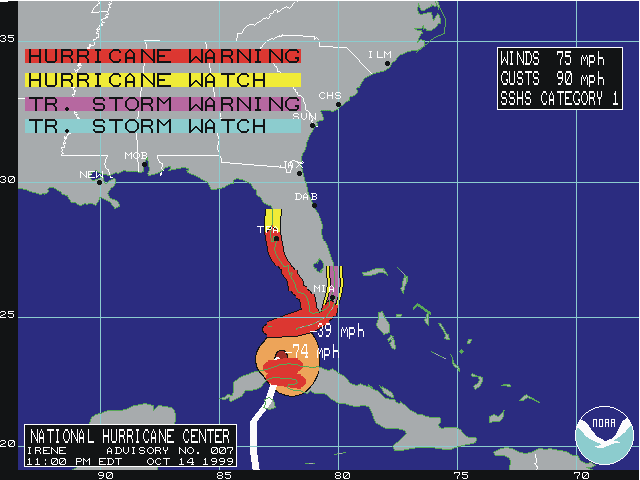
Table 3 lists the numerous watches and warnings issued.
Some residents of southeast Florida expressed displeasure with the NWS
forecasts. Although a tropical storm warning was issued for a portion of
southeast Florida (meaning sustained winds between 39 and 73 mph) as
indicated in Table 3, and torrential rains of 10 to 20 inches with locally
higher amounts were forecast, some residents, especially in southeast
Florida claimed that such conditions were "unexpected" or "surprising".
There is an apparent disconnect between an accurate forecast issued some 36
hours in advance and a public perception of "surprise". The remedial
challenge in this case appears to be related to communications and not to
the forecast. The combined resources of NWS, the emergency management
community and the local media apparently did not adequately convey the
message to the public that: (a) track forecasts are not exact; (b)
hurricanes are not a point but cover a broad area; and (c) serious effects
usually extend for hundreds of miles from the center. Instead, some
residents, as well as isolated TV reporting, focused on the center of Irene.
Indeed, the center of Irene was forecast to move along the west coast of
Florida as indicated by most of the reliable and state-of-the-art track
models shown in Fig. 4a. Instead, the center of Irene
kept moving toward the north-northeast. The NHC nevertheless factored
uncertainties into its forecast advisories and issued warnings appropriately
as shown in Fig. 4b.

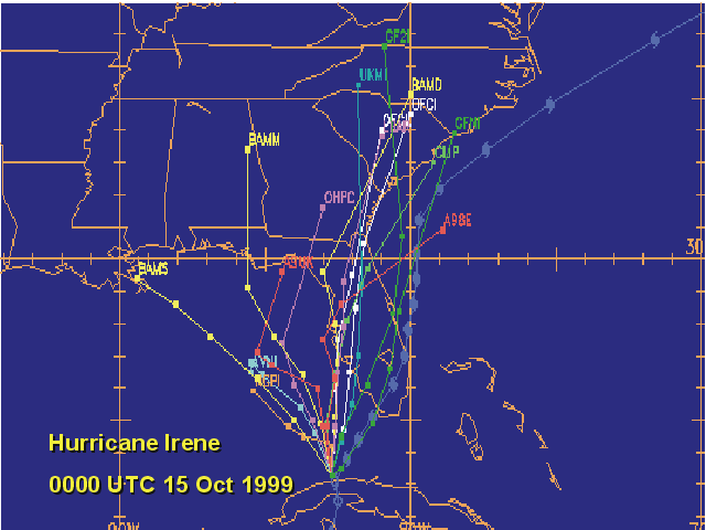
Figure 2.
Best track positions for Hurricane Irene, 13-19 October, 1999.
(A)

(B)

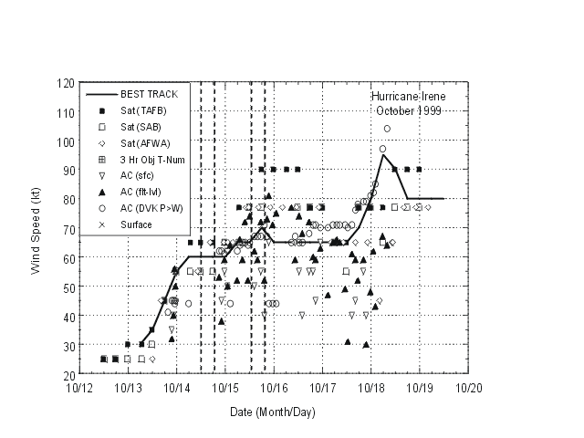
Figure 3.
(A) Preliminary best track minimum central pressure and (B) maximum
sustained wind speed curves for Hurricane Irene. Vertical dashed lines
denote landfalls.
(A)

(B)

Figure 4.
(A) Track forecast models and best track of Irene and (B) warnings and
watches for Irene at 0000 UTC 14 October, 1999.
![[NCEP Logo]](graphics/ncep.gif)