|
Frequently Asked Questions About NOAA/NWS Marine Products and Services
1. Where can I find a marine forecast on the Internet?
2. How can I get a marine forecast or buoy observation over the phone?
3. How can I get a marine forecast via E-mail?
4. Where can I get information on current marine weather conditions and the tide?
5. Where can I get copies of old (archived) forecasts or find climatological information?
6. Where can I find Sea Surface Temperature (SST)
and Gulf Stream information on the Web?
7. I understand that registering my 406 mHz EPIRB
and subsequent 2 year renewals is a
U.S. requirement and the wise thing to do. Who do I contact in NOAA to
register my EPIRB? Where on the Internet can I learn more about EPIRBS?
8. Is the voice I hear on NOAA Weather Radio a computerized voice or a real person?
9. I work for a commercial meteorological services company. What options are available to receive NWS forecasts and data without relying on the Internet?
10. When I'm browsing the Internet and click on one your forecasts, I get an old forecast. What's going on?
11. How can I access the Internet or exchange E-mail while at sea?
12. It seems like I wait forever to hear a marine forecast on NOAA Weather Radio. What's being done?
13. What is a "Small Craft Advisory", Gale Warning, etc?
14. When the marine forecast says "seas 3-5 ft", what exactly does that mean?
15. Your marine forecast for my area was way off last weekend. What happened?
16. I know marine observations are critical to your forecast process. How may I participate in one of your voluntary observing programs?
17. How do I convert knots(kt) to mph, etc?
18. What is the "1-2-3 Rule" used for hurricane avoidence?
19. Why must some radio receivers be tuned 1.9 kHz lower than the assigned frequency to receive radiofax transmissions?
20. Why does my radiofax reception appear to be so poor? Can't the Coast Guard increase the power?
21. Is it true NOAA is terminating the radiofax program?
22. Why don't you broadcast 500 MB radiofax charts from New Orleans or Honolulu like you do for the other radiofax stations?
23. Where can I get a marine forecast for the Indian Ocean, South Atlantic, Mediterranean, etc?
24. Who can I talk to provide comment on my local NOAA Weather Radio broadcast or have some questions answered?
99. Who maintains these Marine Forecast webpages?
1. Where can I find a marine forecast on the Internet?
Go the National Weather Service's Marine Forecasts webpage. This page also provides links to Marine Forecast Offices and Centers which provide links to their products, as well as additional regionally focused information such as buoy observations and tide predictions.
The Marine Forecasts - Products Via Internet webpage provides details on where to find marine related weather products, publications and information on the Internet. This webpage also provides links to Foreign Meteorological Services and Computer Generated Model Guidance which includes data which is outside the area of U.S. marine forecast responsibility.
2. How can I get a marine forecast or buoy observation over the phone?
Most National Weather Service offices keep an updated recording of the forecasts they produce and can be accessed by phone. To find the phone number of the office near you, check your telephone directory under "United States Government, Commerce Department, National Weather Service." A listing of Weather Service Offices with marine recordings is also available. Current
buoy and C-MAN observations (and some marine forecasts) may also be obtained by phone via NDBC's "Dial-A-Buoy"service.
3. How can I get a marine forecast via E-mail?
To get started in using the NWS FTPMAIL service,
follow these simple directions to obtain the FTPMAIL "help" file,
or see: http://weather.noaa.gov/pub/fax/ftpmail.txt.
Caution - Read the help file carefully - 99% of errors using FTPMAIL are simple typo's, incorrect capitalization, failure to send in plain text format, leading or trailing spaces, or failure to set up any spam filters properly.
A webpage describing several different e-mail "robots" similar in concept to FTPMAIL,
including some with advanced features such as allowing retrieval of NWS marine GRIB files, simple webpages, and allowing products to be retrieved on a scheduled, recurring basis may be found at:http://weather.noaa.gov/pub/fax/robots.txt. This webpage may be retrieved via FTPMAIL as follows:
| Send an e-mail to: |
ftpmail@ftpmail.nws.noaa.gov |
| Subject line: |
Put anything you like |
| Body: |
open |
|
cd fax |
|
get robots.txt |
|
quit |
Not all NWS forecast products are available via the tgftp.nws.noaa.gov FTP server and therefore accessible via FTPMAIL such as worldwide computer generated model forecasts which include areas beyond the area of U.S. forecasting responsibility such as the Indian Ocean and South Atlantic. To retrieve Wave Watch III (http://polar.ncep.noaa.gov/waves/main_table.html) and other forecasts via e-mail, use one of the www-to-email systems described in "robots" above. Be aware computer generated products from forecast models are not reviewed by forecasters and are therefore subject to error.
4. Where can I get information on current marine weather conditions and the tide?
Listen to NOAA Weather Radio, see the webpage of your local Weather Forecast Office, or the National Data Buoy Center (NDBC). Current
buoy and C-MAN observations may also be obtained by phone via NDBC's "Dial-A-Buoy" service.
Predicted
Tides,
Currents,
Water Levels and
Lake Levels
are available on the National Ocean Service's Tides and Currents webpage
5. Where can I get copies of old (archived) forecasts or find climatological information?
For the most part, historical marine forecasts are not easily available on the web and must be ordered for a nominal fee. If you wish an official reply, send your written request to:
see http://www.nws.noaa.gov/om/forensic.shtml
The more experienced user may have success obtaining archived forecasts using NCDC's HAS Webpage.
For Historic Weather and Satellite Data Contact:
National Climatic Data Center
151 Patton Avenue, room 120
Asheville, NC 28801-5001
828-271-4800
828-271-4876 (FAX)
weborder@ncdc.noaa.gov
http://lwf.ncdc.noaa.gov/oa/ncdc.html
For Historic Oceanographic Data Contact:
National Oceanographic Data Center
User Services
NOAA/NESDIS E/OC1
SSMC3, 4th Floor
1315 East West Highway
Silver Spring, MD 20910-3282
301-713-3277
301-713-3302 (FAX)
services@nodc.noaa.gov
http://www.nodc.noaa.gov
User-friendly climatological information for marine coastal areas may
be found in Appendix
B of the National Ocean Service's Coast Pilot's, volumes 1-9. These
appendices, which were prepared by the National
Climatic Data Center, also contain other useful meteorological information
such as conversion tables.
The National Geospacial-Intelligence Agency Pilot Charts contain climatological information in graphic form.
6. Where can I find Sea Surface Temperature (SST)
and Gulf Stream information on the Web?
Try these sites on the Web for Sea Surface Temperature (SST) and Gulf
Stream information.
URL Addresses....pay attention to capitalization
NOAA SOURCES
http://polar.ncep.noaa.gov/ofs/
http://polar.ncep.noaa.gov/sst/
http://polar.ncep.noaa.gov/gsf/
http://www.osdpd.noaa.gov/OSDPD/OSDPD_high_prod.html
http://polar.ncep.noaa.gov/
http://www.cdc.noaa.gov/
http://www.nhc.noaa.gov/aboutsst.shtml
http://www.goes.noaa.gov
http://pafc.arh.noaa.gov/ice.php
http://coastwatch.noaa.gov/COASTWATCH/
http://www.aoml.noaa.gov/phod/uot/
http://www.nodc.noaa.gov/GTSPP/gtspp-home.html
http://www.elnino.noaa.gov/
http://manati.orbit.nesdis.noaa.gov/cgi-bin/ws_sst_day_noaa.pl
http://www.opc.ncep.noaa.gov/sst/comparesst2.shtml
NAVY SOURCES
https://www.navo.navy.mil
https://www.fnoc.navy.mil
http://www7300.nrlssc.navy.mil/altimetry/
http://www7320.nrlssc.navy.mil/global_nlom/globalnlom/skill.html
NASA SOURCES
http://seawifs.gsfc.nasa.gov/SEAWIFS/IMAGES/SST.html
UNIVERSITY SOURCES
http://marine.rutgers.edu/mrs/
http://fermi.jhuapl.edu/index.html
http://rads.tudelft.nl/gulfstream/
http://www.thecoolroom.org
DIRECTORY OF PRIVATE WEATHER SERVICES
http://www.weather.gov/im/index.htm
Providers on above webpage which provide Gulfstream information:
Mitchell A. Roffer
President
Roffer's Ocean Fishing Forecasting Service, Inc.
2871 S.W. 69th Court
Miami, FL 33155
PHONE: 800/677-7633 FAX: 305/265-9077
EMAIL: fish@roffs.com
www.roffs.com
Jenifer Clark
Satellite Oceanographer
Jenifer Clark's Gulfstream
5902 Federal Court
Upper Marlboro, MD 20772
PHONE: 301/952-0930 FAX: 301/574-0289
EMAIL: gulfstrm@erols.com
users.erols.com/gulfstrm/
7. I understand that registering my 406 mHz EPIRB
and subsequent 2 year renewals is a
U.S. requirement and the wise thing to do. Who do I contact in NOAA to
register my EPIRB? Where on the Internet can I learn more about EPIRBS?
To register a 406 mHz EPIRB or to learn more about EPIRB's contact:
NOAA SARSAT E/SP3, RM 3320, FB-4
5200 Auth Road
Suitland MD 20746-4304
301-457-5678
888-212-7283 (Toll Free)
301-568-8649(FAX)
osdpd.dsd.reception@noaa.gov
http://www.sarsat.noaa.gov
http://www.navcen.uscg.gov/marcomms/gmdss/epirb.htm
Other users can register their beacon in their country's national beacon registration database or, if no national database is available, in the International Beacon Registration Database at https://www.406registration.com/
8. Is the voice I hear on NOAA Weather Radio a computerized voice or a real person?
You are most likely listening to a computer synthesized voice.
Efforts are underway to both expand the coverage of the NOAA
Weather Radio network and improve the audio quality.
If you hear words in a broadcast which need to have the
pronunciation adjusted, forward your comments to the
appropriate NWS forecast office so they can attempt to improve the
pronunciation.
Please visit NOAA Weather Radio.
9. I work for a commercial meteorological services company. What options are available to receive NWS forecasts and data without relying on the Internet?
Your three most viable options are NOAAPORT, NOAA WX Wire, and Family of Services.
10. When I'm browsing the Internet and click on one your forecasts, I get an old forecast. What's going on?
Always check the time and date of forecasts. Most marine forecasts are updated every six hours and as conditions warrant.
Several types of products are not issued year-round such as recreational and Great Lakes nearshore forecasts. Warning products are generally only issued as required.
You may be unintentionally recalling data from your PC's cache memory. Use the reload/refresh function of your webbrowser to refresh the webpage.
The Internet is not part of the National
Weather Service's operational data stream and should never be relied upon
as a means to obtain the latest forecast and warning data. Become familiar with
and use other means such as NOAA Weather Radio
to obtain the latest forecasts and warnings. Please read
our disclaimer.
11. How can I access the Internet or exchange E-mail while at sea?
The Marine Forecasts - Products Via Internet webpage provides information on how mariners may access the Internet and exchange E-mail via radio, cellular, and satellite technologies.
12. It seems like I wait forever to hear a marine forecast on NOAA Weather Radio. What's being done?
The NOAA Weather Radio network is being continually expanded to reduce each transmitters workload and increase coverage. Several NOAA Weather Radio transmitters operate as "Marine-Only", broadcasting marine information on a more rapid cycle than is possible with "All-Hazard" transmitters. These are typically established as part of a cooperative effort between the local marine community and the National Weather Service. For information on how to establish a "Marine-Only" NOAA Weather Radio transmitter in your area, contact the National Weather Service.
13. What is a "Small Craft Advisory", Gale Warning, etc?
For further informations on these and other marine terms, see the NWS Glossary, the Marine, Tropical Cyclone, and Tsunami program's directives and Nathaniel Bowditch's "The
American Practical Navigator"
Small Craft Advisory (SCA): An advisory issued by coastal and Great Lakes Weather Forecast
Offices (WFO) for areas included in the Coastal Waters Forecast or Nearshore Marine Forecast
(NSH) products. Thresholds governing the issuance of small craft advisories are specific to
geographic areas. A Small Craft Advisory may also be issued when sea or lake ice exists that could be hazardous to small boats.
There is no precise definition of a small craft. Any vessel that may be adversely
affected by Small Craft Advisory criteria should be considered a small craft. Other considerations include the experience of the
vessel operator, and the type, overall size, and sea worthiness of the vessel.
Eastern (ME..SC, Lake Erie, Lake Ontario) - Sustained winds or frequent gusts ranging between 25 and 33 knots
(except 20 to 25 knots, lower threshold area dependent, to 33 knots for
harbors, bays, etc.) and/or seas or waves 5 to 7 feet and greater, area
dependent.
Central (MN..OH) - Sustained winds or frequent gusts (on the Great Lakes) between 22 and
33 knots inclusive, and/or seas or waves greater than 4 feet.
Southern (GA..TX and Caribbean) - Sustained winds of 20 to 33 knots, and/or forecast seas 7 feet or greater
that are expected for more than 2 hours.
Western (WA..CA) - Sustained winds of 21 to 33 knots, and/or wave heights exceeding 10 feet (or wave steepness values exceeding local thresholds).
Alaska (AK) - Sustained winds or frequent gusts of 23 to 33 knots. A small craft
advisory for rough seas may be issued for sea/wave conditions deemed
locally significant, based on user needs, and should be no lower than 8
feet.
Pacific (HI, Guam, etc) - Sustained winds 25 knots or greater and seas 10 feet or greater; except
in Guam and the northern Mariana Islands where it is sustained winds
22 to 33 knots and/or combined seas of 10 feet or greater.
"Frequent gusts"are typically long duration conditions (greater than 2 hours).
For a list of NWS Weather Offices by Region, refer to the following website:
http://www.nws.noaa.gov/organization.php
Small Craft Advisory for Hazardous Seas (SCAHS): An advisory for wind speeds lower than small craft advisory criteria, yet waves or seas are potentially hazardous due to wave height, wave period, steepness, or swell direction. Thresholds governing the issuance of Small Craft. Advisories for Hazardous Seas are specific to geographic areas.
Eastern (ME..SC, Lake Erie, Lake Ontario) - Seas or waves 5 to 7 feet and greater, area dependent.
Central (WI..OH) - Seas or waves greater than 4 feet.
Southern (GA..TX and Caribbean) - Seas 7 feet or greater that are expected for more than 2 hours.
Western (WA..CA) - Criteria for wave heights and/or wave steepness are locally defined; refer to Western Region Supplement 12-2003, Marine Weather Services.
Alaska (AK) - Seas or wave conditions deemed locally significant, based on user
needs, and should be no lower than 8 feet.
Pacific (HI, Guam, etc) - Seas 10 feet or greater.
Small Craft Advisory for Rough Bar (SCARB): An advisory for specialized areas near harbor or river entrances known as bars. Waves in or near such bars may be especially hazardous to mariners due to the interaction of swell, tidal and/or river currents in relatively shallow water. Thresholds governing the issuance of Small Craft Advisories for Rough Bar are specific to local geographic areas, and are based upon parameters such as wave steepness, wind speed and direction, and local bathymetry.
Small Craft Advisory for Winds (SCAW): An advisory for wave heights lower than small craft advisory criteria, yet wind speeds are potentially hazardous. Thresholds governing the issuance of small craft advisories are specific to geographic areas.
Eastern (ME..SC, Lake Erie, Lake Ontario) - Sustained winds ranging between 25 and 33 knots (except 20 to 25
knots, lower threshold area dependent, to 33 knots for harbors, bays,
etc.)
Central (WI..OH) - Sustained winds or frequent gusts (on the Great Lakes) between 22 and
33 knots inclusive.
Southern (GA..TX and Caribbean) - Sustained winds of 20 to 33 knots that are expected for more than 2
hours.
Western (WA..CA) - Sustained winds of 21 to 33 knots.
Alaska (AK) - Sustained winds or frequent gusts of 23 to 33 knots.
Pacific (HI, Guam, etc) - Sustained winds 25 knots or greater; except in Guam where it is
sustained winds of 22 to 33 knots.
BRISK WIND ADVISORY: A Small Craft Advisory issued for ice-covered waters.
GALE WARNING: A warning of sustained surface winds, or frequent gusts, in the range of 34 knots
(39 mph) to 47 knots (54 mph) inclusive, either predicted or occurring, and not directly
associated with a tropical cyclone.
STORM WARNING: A warning of sustained surface winds, or frequent gusts, in the range of 48
knots (55 mph) to 63 knots (73 mph) inclusive, either predicted or occurring, and not directly
associated with a tropical cyclone.
TROPICAL STORM WARNING: A warning for sustained surface winds, associated with a tropical
cyclone, within the range of 34 to 63 knots (39 to 73 mph), expected in a specified coastal area
within 24 hours.
HURRICANE FORCE WIND WARNING: A warning for sustained winds, or frequent gusts, of 64 knots
(74 mph) or greater, either predicted or occurring, and not directly associated with a tropical
cyclone.
HURRICANE WARNING: A warning for sustained surface winds of 64 knots (74 mph) or higher
associated with a hurricane are expected in a specified coastal area within 24 hours or less. A
hurricane or typhoon warning can remain in effect when dangerously high water or a
combination of dangerously high water and exceptionally high waves continue even though
winds may be less than hurricane force.
Other Advisories, Watches and Warmings for Marine Areas:
Ashfall Advisory: An advisory issued for conditions associated with airborne ash plume resulting in ongoing deposition at the surface. Ashfall may originate directly from a volcanic eruption, or indirectly by wind suspending the ash.
Coastal/Lakeshore Flood Advisory: Flooding is possible (i.e, over and
above normal high tide levels. Coastal/Lakeshore Flood Advisories are issued using the Coastal and Lakeshore Hazard Message (CFW) product.
Coastal/Lakeshore Flood Watch: Flooding
with significant impacts is possible. Coastal/Lakeshore Flood Watches are issued using the Coastal and Lakeshore Hazard Message (CFW) product.
Coastal/Lakeshore Flood Warning: Flooding that will pose a serious threat to life and property is occurring, imminent or highly
likely. Coastal/Lakeshore Flood Warnings are issued using the Coastal and Lakeshore Hazard Message (CFW) product.
Dense Fog Advisory: : An advisory for widespread or localized fog reducing visibilities to regionally or locally defined limitations not to exceed 1 nautical mile.
Dense Smoke Advisory: : An advisory for widespread or localized smoke reducing visibilities to regionally or locally defined limitations not to exceed 1 nautical mile.
Freezing Spray Advisory: An advisory for an accumulation of freezing water droplets on a vessel at a rate of less than 2 centimeters (cm) per hour caused by some appropriate combination of cold water, wind, cold air temperature, and vessel movement.
Gale Watch: Conditions are favorable for a gale force wind event to meet the Gale Warning criteria of sustained winds or frequent gusts of 34 knots (39 mph) to 47 knots (54 mph) in the next 12 to 48 hours.
Hazardous Seas Watch: Conditions are favorable for a hazardous seas event to meet or exceed Hazardous Seas Warning criteria in the next 12 to 48 hours.
Heavy Freezing Spray Warning: A warning for an accumulation of freezing water droplets on a
vessel at a rate of 2 cm per hour or greater caused by some appropriate combination of cold water, wind, cold air temperature, and vessel movement.
Heavy Freezing Spray Watch:
Conditions are favorable for a heavy freezing spray event to meet local Heavy Freezing Spray Warning criteria in the next 12 to 48 hours.
High Surf Advisory: . A High Surf Advisory is issued when breaking wave action poses a threat
to life and property within the surf zone. High surf criteria varies by region. High Surf
Advisories are issued using the Coastal Hazard Message (CFW) product.
High Surf Warning: A High Surf Warning is issued when breaking wave action results in an
especially heightened threat to life and property within the surf zone. High surf criteria varies by
region. High Surf Warnings are issued using the Coastal and Lakeshore Hazard Message (CFW)
product.
Hurricane Force Wind Watch: Conditions are favorable for a hurricane force wind event to meet or exceed Hurricane Force Wind Warning criteria of sustained winds or frequent gusts of 64 knots (74 mph) or greater in the next 12 to 48 hours.
Low Water Advisory: An advisory to describe water levels which are significantly below average levels over the Great Lakes, coastal marine zones, and any tidal marine area, waterway, or river inlet within or adjacent to a marine zone that would potentially be impacted by low water conditions creating a hazard to navigation.
Severe Thunderstorm Watch: A watch issued when conditions become favorable for severe thunderstorms to develop and headlined in the Coastal Waters Forecast, the Great Lakes Open Lakes Forecast, and the Nearshore Marine Forecast. Reference NWSI 10-512 for severe thunderstorm watch criteria.
Special Marine Warning (SMW): A warning product issued for potentially hazardous weather conditions
usually of short duration (up to 2 hours) producing sustained marine thunderstorm winds or
associated gusts of 34 knots or greater; and/or hail 3/4 inch or more in diameter; and/or
waterspouts affecting areas included in a Coastal Waters Forecast, a Nearshore Marine Forecast,
or an Great Lakes Open Lakes Forecast that is not adequately covered by existing marine
warnings. Also used for short duration mesoscale events such as a strong cold front, gravity
wave, squall line, etc., lasting less than 2 hours and producing winds or gusts of 34 knots or
greater.
Storm Watch: Conditions are favorable for a storm force wind event to meet Storm Warning criteria of sustained winds or frequent gusts of 48 knots (55 mph) to 63 knots (73 mph) in the next 12 to 48 hours.
Tornado Watch: A watch issued when conditions become favorable for tornadoes to develop and
headlined in the Coastal Waters Forecast, the Great Lakes Open Lakes Forecast, and the
Nearshore Marine Forecast . Reference NWSI 10-512 for tornado watch criteria.
Tsunami Advisory:
For products of the Pacific Tsunami Warning Center (PTWC - Pacific (except Alaska, British Columbia and Western States) Hawaii, Caribbean (except Puerto Rico, Virgin Is.), Indian Ocean):
The third highest level of tsunami alert. Advisories are issued to coastal populations within areas not currently in either warning or watch status when a tsunami warning has been issued for another region of the same ocean. An Advisory indicates that an area is either outside the current warning and watch regions or that the tsunami poses no danger to that area. The Center will continue to monitor the event, issuing updates at least hourly. As conditions warrant, the Advisory will either be continued, upgraded to a watch or warning, or ended.
For products of the West Coast/Alaska Tsunami Warning Center (WC/ATWC - Alaska, British Columbia and Western States, Canada, Eastern and Gulf States, Puerto Rico, U.S Virgin Islands):
A tsunami advisory is issued due to the threat of a potential tsunami which may produce strong currents or waves dangerous to those in or near the water. Coastal regions historically prone to damage due to strong currents induced by tsunamis are at the greatest risk. The threat may continue for several hours after the arrival of the initial wave, but significant widespread inundation is not expected for areas under an advisory. Appropriate actions to be taken by local officials may include closing beaches, evacuating harbors and marinas, and the repositioning of ships to deep waters when there is time to safely do so. Advisories are normally updated to continue the advisory, expand/contract affected areas, upgrade to a warning, or cancel the advisory.
Tsunami Watch:
For products of the Pacific Tsunami Warning Center (PTWC - Pacific (except Alaska, British Columbia and Western States) Hawaii, Caribbean (except Puerto Rico, Virgin Is.), Indian Ocean):
The second highest level of tsunami alert. Watches are issued based on seismic information without confirmation that a destructive tsunami is underway. It is issued as a means of providing an advance alert to areas that could be impacted by destructive tsunami waves. Watches are updated at least hourly to continue them, expand their coverage, upgrade them to a Warning, or end the alert. A Watch for a particular area may be included in the text of the message that disseminates a Warning for another area.
For products of the West Coast/Alaska Tsunami Warning Center (WC/ATWC - Alaska, British Columbia and Western States, Canada, Eastern and Gulf States, Puerto Rico, U.S Virgin Islands):
A tsunami watch is issued to alert emergency management officials and the public of an event which may later impact the watch area. The watch area may be upgraded to a warning or advisory - or canceled - based on updated information and analysis. Therefore, emergency management officials and the public should prepare to take action. Watches are normally issued based on seismic information without confirmation that a destructive tsunami is underway.
An advance alert to areas that could be impacted by destructive tsunami waves based on seismic information without confirmation that a destructive tsunami is underway
Tsunami Warning:
For products of the Pacific Tsunami Warning Center (PTWC - Pacific (except Alaska, British Columbia and Western States) Hawaii, Caribbean (except Puerto Rico, Virgin Is.), Indian Ocean):
The highest level of tsunami alert. Warnings are issued due to the imminent threat of a tsunami from a large undersea earthquake or following confirmation that a potentially destructive tsunami is underway. They may initially be based only on seismic information as a means of providing the earliest possible alert. Warnings advise that appropriate actions be taken in response to the tsunami threat. Such actions could include the evacuation of low-lying coastal areas and the movement of boats and ships out of harbors to deep water. Warnings are updated at least hourly or as conditions warrant to continue, expand, restrict, or end the warning.
For products of the West Coast/Alaska Tsunami Warning Center (WC/ATWC - Alaska, British Columbia and Western States, Canada, Eastern and Gulf States, Puerto Rico, U.S Virgin Islands):
A tsunami warning is issued when a potential tsunami with significant widespread inundation is imminent or expected. Warnings alert the public that widespread, dangerous coastal flooding accompanied by powerful currents is possible and may continue for several hours after arrival of the initial wave. Warnings also alert emergency management officials to take action for the entire tsunami hazard zone. Appropriate actions to be taken by local officials may include the evacuation of low-lying coastal areas, and the repositioning of ships to deep waters when there is time to safely do so. Warnings may be updated, adjusted geographically, downgraded, or canceled. To provide the earliest possible alert, initial warnings are normally based only on seismic information.
14. When the marine forecast says "seas 3-5 ft", what exactly does that mean?
Waves are measured from trough to crest. Seas are the combination of both locally generated wind waves and distantly generated swell waves. Specifically, seas may be derived using the following formula where S is the height of the swell waves and W is the height of the wind waves.
SEAS = 
Seas and waves are expressed in the terms of the significant wave height, the mean or average height of the highest one third of all waves in a swell train or in a wave generating region. It approximates the value an experienced observer would report if visually estimating sea height. When expressed as a range (e.g. seas 3-5 ft), this indicates a degree of uncertainty in the forecast and/or expected changing conditions (not that all waves are between 3-5 ft). Generally, it is assumed that individual wave heights can be described using a Rayleigh distribution.
Example: Significant Wave Height = 10 ft
1 in 10 waves will be larger than 11 ft
1 in 100 waves will be larger than 16 ft
1 in 1000 waves will larger than 19 ft
There are occasional reports of "rogue" waves of an even greater ratio
Therefore, assuming a wave period of 8 seconds, for a significant wave height of 10 feet, a wave 19 feet or higher will occur every 8,000 seconds (2.2 hours).
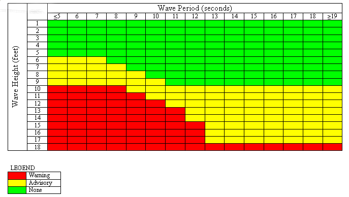
The danger presented to a vessel is a function of wave steepness as well as wave height and is unique to each vessel. In general for small vessels, for a given wave height the danger increases as the wave period decreases. Below is a table under development within the National Weather Service to assist forecasters in identifying sea conditions which may be of danger to vessels with a closed cockpit configuration of ~100 feet or less. The table is intended to be instructional only and the danger presented by waves to your own vessel may be quite different.
15. Your marine forecast for my area was way off last weekend. What happened?
Weather forecasting is not a perfect science and conditions can change rapidly and unexpectedly. Always make certain you have the latest forecast and keep abreast of weather warnings via NOAA Weather Radio and other means. Most marine forecasts are updated every six hours and as conditions warrant.
Marine forecasting is made much more difficult than forecasting ashore due to a lack of available observations. Observations are required for NWS computer forecast models and by the forecaster to provide value-added decision making to the computer model output. Observations also serve to alert the forecaster when NWS forecasts do not agree the actual conditions and therefore, a problem exists in the current forecast process. Whereas 1000's of observations might be available for your local land forecast, only one or two observations might be available for the local marine forecast. NWS is continually working to expand its network of buoy and C-MAN stations, and volunteer observers.
The conditions in your location can be different than the general marine forecast due to local effects. For example, a strong land breeze might serve to flatten the waves immediately along the coast. A strong current, such as around a jetty or associated with the Gulf Stream, can increase wave heights.
Be aware that wave forecasts are an average. The height of some individual waves can be expected to be as much as two times greater. Reports of "rogue" waves of even greater heights are not uncommon. See FAQ question #14.
16. I know marine observations are critical to your forecast process. How may I participate in one of your voluntary observing programs?
See Voluntary Marine Observation Programs
17. How do I convert knots(kt) to mph, etc?
Some common unit conversions for mariners:
1 knot(kt) = 1.15 mph = .51 meters/sec
1 nautical mile (nm)= 1.15 statute miles = 1852 meters
1 millibar (mb) mercury = .02953 inches mercury
Fahrenheit = 1.8*(Celsius) + 32
1 fathom = 6 feet
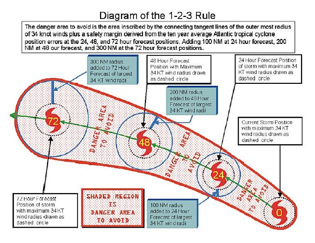
18. What is the "1-2-3 Rule" used for hurricane avoidance?
The 1-2-3 Rule is means of avoiding winds associated with a tropical cyclone by taking into account the forecast track error of the National Weather Service over a 10 year period which is approximately 100 nm in 24 hours, 200 nm for 48 hours and 300 nm in 72 hours. The forecast track error is added to the 34 knot wind radii to compute the danger area. The wind radii may be found within Tropical Cyclone Forecast Advisory (TCM) forecasts. For more detailed information on the 1-2-3 Rule, see the National Hurricane Center's Marine Safety Page
The National Hurricane Center and Central Pacific Hurricane Center also prepare Atlantic, East Pacific and Central Pacific "Tropical Cyclone Danger Area" charts for broadcast via radiofax, depicting the danger area computed using the 1-2-3 Rule as a basis. The danger area will not be depicted for tropical cyclones that transition to extratropical status.
19. Why must some radio receivers be tuned 1.9 kHz lower than the assigned frequency to receive radiofax transmissions?
Radiofax is a means of transmitting black and white pictures by shifting the frequency of the transmitter. -400 Hz=black, 0Hz=grey, +400 Hz=white. The center of these radiofax transmissions is known as the assigned frequency.
In order for these transmissions to be received as tones for further processing, the radiofax receiver must be tuned to a lower "carrier" frequency, due to the manner in which radios operate. A convention of 1900 Hz (1.9 kHz) lower has been selected for the majority of radiofax receiving systems. The following will then be heard on the receiver: black=1500 Hz, grey=1900 Hz, white=2300 Hz. The receiver must also be operated in the Upper Sideband (USB) mode or the signal will be heard as dead air rather than as a tone.
To confuse the issue, many dedicated radiofax receivers allow the user to dial in the assigned frequency while the actual electronics is tuned to a carrier frequency 1.9 kHz lower. In general, dedicated radiofax receivers use assigned frequencies, while receivers or transceivers, connected to external recorders or PC's, are operated in the upper sideband (USB) mode using carrier frequencies.
20. Why does my radiofax reception appear to be so poor? Can't the Coast Guard increase the power?
Be certain you are listening on a frequency appropriate to your operating area and time of day and have tried all available frequencies. Propagation can change frequently.
In most instances, there's little that can be done as this is primarily related to where we are in relation to the 11 year sunspot cycle, and this is very bad cycle as well, which is all but wiping out long distance HF communication. If the Coast Guard were to double the power to 10KW, this would only bring about a 3db improvement on the receive side which would barely be noticeable, while greatly adding to the wear and tear on the Coast Guard's aging inventory of HF transmitters and putting the program at risk.
There are wide variations in user's equipment. In general you may get better reception using a modern specialized radiofax receiver, however, there is little that can be done with a truly weak signal due to poor propagation.
If you have e-mail capability, please check out our FTPMAIL system as a means of receiving radiofax charts, see
FAQ #3
21. Is it true NOAA is terminating the radiofax program?
NOAA has not put forth any plans proposing to curtail radiofax charts since 1995. No changes degrading service are currently under consideration.
In 2007 the U.S. Coast Guard sought public comment on the need to recapitalize their equipment to be able to continue broadcasting weather via HF, including radiofax. Based on the response to the proposal and a report prepared under contract, the decision made by the Coast Guard to fully recapitalize their transmitters used for weather broadcasts and continue providing high frequency (HF) radio broadcasts of weather forecasts and warnings.
The prudent mariner is strongly urged to carry redundant equipment such as a spare HF receiver and acquire means to download text and radiofax forecasts via e-mail (FTPMAIL).
22. Why don't you broadcast 500 MB radiofax charts from New Orleans or Honolulu like you do for the other radiofax stations?
500 MB charts are not made available for tropical areas via radiofax as they are of limited value in determining future trends according to our staff meteorologists forecasting for these areas, and therefore not produced with our limited resourses.
Some computer-generated upper air charts are available at the following links:
GTS RMTN-IV Standard Heights Charts
NWS Standard Barotropic Level Fax Charts
Alaskan Standard Heights Fax Charts
WAFS Facsimile (T4) Charts
23. Where can I get a marine forecast for the Indian Ocean, South Atlantic, Mediterranean, etc?
For the Indian Ocean, South Atlantic, Mediterranean, etc. the U.S.
National Weather Service's forecasting responsibilities do not extend
to those areas although we do have some model guidance available, e.g.
NOAA Wave Watch III - Tabular Interface and charts other than "MarineFax" at Weather Charts on the NET. Be aware these are computer generated images from forecast models and are therefore subject to error.
If you only have e-mail capability without direct Internet access, a
webpage describing several different e-mail "robots" similar in concept
to our FTPMAIL service, including some with advanced features such as
allowing retrieval of NWS marine GRIB files,simple webpages, and allowing
products to be retrieved on a scheduled, recurring basis may be found at:
http://weather.noaa.gov/pub/fax/robots.txt
For worldwide radiofax broadcast schedules worldwide visit:
Worldwide Marine Radiofacsimile
Broadcast Schedules (PDF)
British Admiralty List of Signals Volume 3 (2 parts)
Links to foreign meteorological services are available courtesy of the World Meteorological Organization (WMO.
Meteo France hosts a webpage (weather.gmdss.org) with links to
nearly all international marine forecasts broadcast via Inmarsat-C/SafetyNET.
Also try these U.S. Navy links
https://www.fnmoc.navy.mil/
https://www.navo.navy.mil/
24. Who can I talk to provide comment on my local NOAA Weather Radio broadcast or have some questions answered?
Write or call your local Weather Forecast Office
99. Who maintains these Marine Forecast webpages?
The Marine Forecast webpages under the www.nws.noaa.gov/om/marine domain are maintained by one government employee on a 25% basis, however, the underlying infrastructure and forecasting capability rely on the staff of practically the entire National Weather Service. For questions or comments on the National Weather Service's marine weather program CLICK HERE.
|


