Tsunami Data at NGDC
|
A tsunami is a series of waves generated by an impulsive disturbance in the ocean or in a small, connected body of water. These waves sometimes inflict severe damage to property and pose a threat to life in coastal communities. NGDC and the co-located World Data Center for Geophysics and Marine Geology have compiled a unique set of tsunami-related products as part of a continuing program to support the interests of engineers, oceanographers, seismologists, and the general public. These data products include historic tsunami data, technical publications, and photographs. Please see the Copyright Notice if you plan to use data from this web site or government agency.
|
Recent Events
- Peru 2007 Aug 15:
Event,
Runups,
Calculated Travel Time Map, and
Interactive Map
- Solomon Islands 2007 Apr 1:
Event,
Runups,
Photos,
Calculated Travel Time Map, and
Interactive Map
- Kuril Islands 2007 Jan 13:
Event,
Runups,
Calculated Travel Time Map, and
Interactive Map
- Kuril Islands 2006 Nov 15:
Event,
Runups,
Calculated Travel Time Map, and
Interactive Map
- Indian Ocean 2004 Dec 26:
Event,
Runups,
Photos,
Calculated Travel Time Map, and
Interactive Map
|
- Global Tsunami Database
- This database provides information on tsunami source events and locations where effects from tsunamis were observed. It includes events from 2000 B.C. to the present in the the Atlantic, Indian, and Pacific Oceans; and the Mediterranean and Caribbean Seas. The NGDC Hazards databases can also be displayed and extracted with the ArcIMS Interactive Map or displayed with Google Earth by downloading our Natural Hazards KML file.
- Coming Soon: Tsunami Deposits and Proxies for Tsunami Events - Information regarding Tsunami Deposits and Proxies for Tsunami Events complements the historical records currently available through the Global Tsunami Database.
Deep-ocean Assessment and Reporting of Tsunamis (DART) Data- The Bottom Pressure Recorder (BPR) data from 1986 to 2004 are available for download.
New! Tide Gage Data- NGDC is currently archiving all 1-minute water level data from the NOAA/NOS Center for Operational Oceanographic Products and Services (CO-OPS). Additionally, more than 3,000 tide gage records for tsunami events (1850 to 1981) from U.S. and foreign tide stations are available on microfiche.
Tsunami Inundation Gridding Project- The National Geophysical Data Center (NGDC) supports the NOAA Center for Tsunami Research at the Pacific Marine Environmental Laboratory (PMEL) by developing high-resolution digital elevation models (DEMs) for select U.S. coastal regions. These combined bathymetric-topographic DEMs are part of the tsunami forecast system SIFT (Short-term Inundation Forecasting for Tsunamis) currently being developed by PMEL for the NOAA Tsunami Warning Centers. The coastal inundation DEMs are used in the Method of Splitting Tsunami (MOST) model developed by PMEL to simulate tsunami generation, propagation, and inundation.
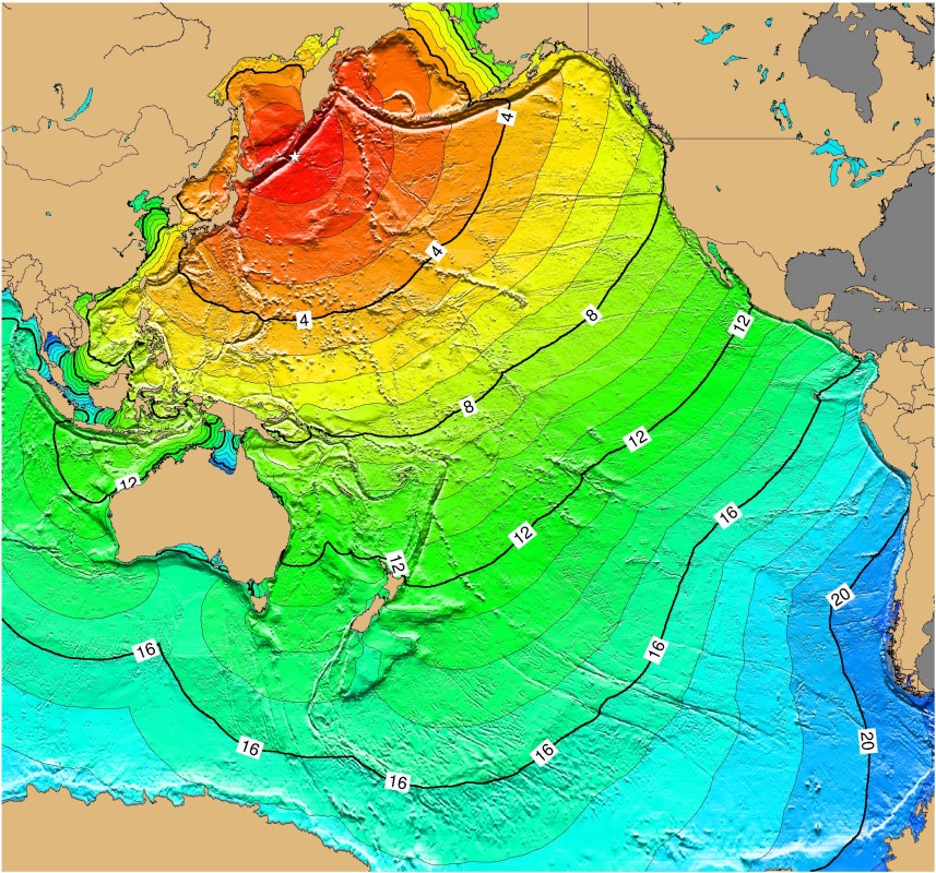
Tsunami-Travel-Time Maps- NGDC has generated images of tsunami travel times for several major tsunamis.
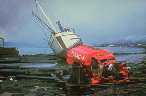
Tsunami Images - NGDC offers several unique sets of images (digital or 35mm) illustrating tsunami effects and damage.
Tsunami Publications- NGDC offers a variety of publications containing scientific data, records, photos, and information of historic and recent tsunami events.
Other Tsunami Links:- International Tsunami Information Center
- NOAA Tsunami Information
- National Tsunami Hazard Hazard Mitigation Program
- NOAA Pacific Marine Environment Laboratory Tsunami Program
- NOAA Pacific Tsunami Warning Center
- NOAA West Coast and Alaska Tsunami Warning Center
- NOAA CO-OPS Water Level Data
- Tsunami Laboratory, Novosibirsk, Russia
|
|
