NESDIS banner image OSDPD banner image
link to the NOAA Home page  link to the National
Environmental Satellite, Data, and Information Service Home Page

Menu of Highlighted Products

Information Processing Division (IPD)

Special Bulletins
SATOPS Morning Report

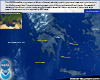
POES Satellite Imagery

Environmental Products
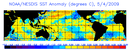
SST Anomalies
Sea Surface Temperature Anomalies image

Coral Bleaching Hot Spots
Degree Heating Weeks
Coral Bleaching Indices
SST Analyzed Fields
SST Contour Charts
CoastWatch
Radiation Budget
Aerosol Optical Thickness

Ozone
Link to the Ozone Products home page

Soundings
ATOVS
VSTATS

WEFAX
2km CONUS Imagery
Link to the Experimental 2km Continental U.S. Images home page

Vegetation Index Products
AVHRR Mapped Composites
AMSU Derived Composites
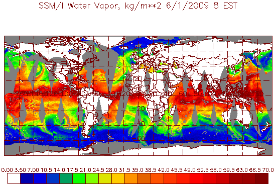
SSM/I Derived Products
Link to the Shared Processing home page


Polar Calibration
Navigation
Polar Ingest
DMSP Ingest Schedules

GOES WEFAX Schedules
East
West

NOAA MODIS Near Real Time
CONUS image
CONUS Daily Images
AM Satellite
PM Satellite

Satellite Services Division (SSD)

Operational Significant Events Imagery

Operational Significant Event Image Of The Day
OSEI Image of the Day

CEOS Disaster Management
Support Group Server

GOES
SATELLITE IMAGERY
East Continental U.S. Infrared Image
East Coast

West Continental U.S. Infrared Image

West Coast

High Density Wind
Tropical Cyclones
Precipitation Products
Volcanic Ash

Interactive Multisensor
Snow and Ice Mapping System
Link to the Satellite Services Division's Snow and Ice images


Last Modified February 22, 2008 (cav)
OSDPD Webmaster.