Damaging Winds Basics
Winds from thunderstorms
Damage from severe thunderstorm winds account for half of all severe reports in the lower 48 states and is more common than damage from tornadoes. Wind speeds can reach up to 100mph and can produce a damage path extending for hundreds of miles. These winds are often called "straight-line" winds to differentiate the damage they cause from tornado damage. Strong thunderstorm winds can come from a number of different processes. Damaging winds are classified as those exceeding 50-60mph.
Since most thunderstorms produce some straight-line winds as a result of outflow generated by the thunderstorm downdraft, anyone living in thunderstorm-prone areas of the world is at risk for experiencing this phenomenon.
Types of damaging winds
Straight-line winds – a term used to define any thunderstorm wind that is not associated with rotation, and is used mainly to differentiate from tornadic winds.
Downdrafts – A small-scale column of air that rapidly sinks toward the ground. A downburst is a result of a strong downdraft.
This wet microburst shows a characteristic well-defined foot shape on the left side of the rain shaft. Photo © Charles Doswell |
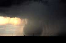
A central Oklahoma microburst descends from the parent cloud to the ground. Photo © Bill Bunting |
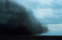
A gust front made visible by dust shows a characteristic profile, produced by sinking rain-cooled air, that extends farther forward near the ground but is held back at the ground by friction. Photo © Irv Watson |
Downbursts – A strong downdraft with horizontal dimensions larger than 4 km (2.5 mi) resulting in an outward burst or damaging winds on or near the ground. (Imagine the way water comes out of a faucet and hits the bottom of the sink.) Downburst winds may begin as a microburst and spread out over a wider area, sometimes producing damage similar to a strong tornado. Although usually associated with thunderstorms, downbursts can occur with showers too weak to produce thunder.
Microbursts – A small concentrated downburst that produces an outward burst of damaging winds at the surface. Microbursts are generally small (less than 4km across) and short-lived, lasting only 5-10 minutes, with maximum windspeeds up to 168 mph. There are two kinds of microbursts: wet and dry. A wet microburst is accompanied by heavy precipitation at the surface. Dry microbursts, common in places like the high plains and the intermountain west, occur with little or no precipitation reaching the ground.
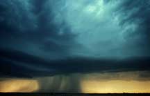
Gust front – A gust front is the leading edge of rain-cooled air that clashes with warmer thunderstorm inflow. Gust fronts are characterized by a wind shift, temperature drop, and gusty winds out ahead of a thunderstorm. Sometimes the winds push up air above them, forming a shelf cloud or detached roll cloud.
Derecho – A derecho is a widespread thunderstorm wind event caused when new thunderstorms form along the leading edge of an outflow boundary (a surface boundary formed by the horizontal spreading of thunderstorm-cooled air). The thunderstorms feed on this boundary and continue to reproduce themselves. Derechos typically occur in the summer months when complexes of thunderstorms form over the plains and northern plains states. Usually these thunderstorms produce heavy rain and severe wind reports as they rumble across several states during the night. The word "derecho" is of Spanish origin and means "straight ahead". They are particularly dangerous because the damaging winds can last a long time and can cover such a large area.
Bow Echo – A radar echo which is linear but bent outward in a bow shape. Damaging straight-line winds often occur near the "crest" or center of a bow echo. Bow echoes can be over 300km in length, last for several hours, and produce extensive swaths of wind damage at the ground.
HOW DOES NSSL CONTRIBUTE?
BAMEX
BAMEX (Bow Echo and MCV Experiment) was a field experiment
involving scientists from NSSL, NCAR, the NWS, and OU that was designed
to gather data to understand bow echoes and their resulting high damaging
surface winds. The mobile project tried to understand and improve prediction
of mesoscale and storm-scale processes that produce severe winds in bowing
convective systems lasting at least 4 hours. The project used aircraft
and mobile ground-based instruments to map the thermodynamic and environmental
structure of thunderstorm complexes and mature mesoscale convective vortices.
Damaging winds associated with low-altitude mesovortices within
bow echoes
An NSSL scientist studied low-altitude "mesovortices",
(atmospheric spin on the scale of a few km to several hundred km) and
learned that they may be the one of the causes of damaging straight-line
winds. These results helped motivate the objectives for the BAMEX program
defined above.
