|
|
News Release
|
Announcement 8/17/2001
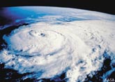
The first official visual image from GOES-12, the nations newest
and most advanced Geostationary Operational Environmental Satellite,
was captured today starting approximately 02:00 EDT at the Satellite
Operations and Command Center (SOCC) in Suitland, MD. Scott
Gudes, Acting Undersecretary & NOAA Administrator, along
with Greg Withee, AA Satellite and Information Services, John
Jones, Deputy AA for Weather Services, and Kathy Kelly, Director
Office of Satellite Operations, made acknowledgments and relayed
thanks to key players and the entire team that was responsible
for the launch and on-orbit testing. GOES-12 was successfully
launched on July 23 at 07:23:01z and is the first of the series
to carry an operational Solar X-ray Imager (SXI) that will enable
scientists and solar weather forecasters to better understand
and predict events on the Sun that impact activities on Earth
and in orbit.

First official visual image from GOES-12
Archive
Past news releases
SATOPS Morning Report
Home | Operations |
News | Daily Updates |
Info & History
GOES | POES |
DMSP | Contact Us |
Internal
Webmaster
Privacy Act Notice
|
|
|


 DOC
NOAA
NESDIS
DOC
NOAA
NESDIS