| NOAA Magazine || NOAA Home Page |
NOAA IDENTIFIES CAUSES FOR LATEST WET WEATHER IN WEST
 Feb.
25, 2005 � Storm-fatigued Southern Californians will catch their breath
again as mainly dry conditions are forecast into the weekend following
the latest round of remarkable precipitation. NOAA
National Weather Service meteorologists have closely examined the
ocean-atmosphere conditions, which influenced the most recent round
of California storms. Unlike the period from late December through early
January, the latest period of heavy precipitation was related to two
conditions: the ongoing weak, but diminishing, El
Niño in the tropical Pacific, and a blocking pattern over
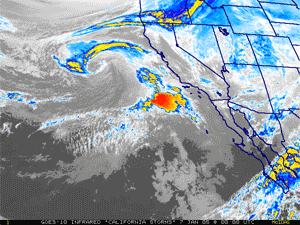
western North America. (NOAA animation of satellite images taken
from December 2004 and January 2005. Please credit “NOAA.”)
Feb.
25, 2005 � Storm-fatigued Southern Californians will catch their breath
again as mainly dry conditions are forecast into the weekend following
the latest round of remarkable precipitation. NOAA
National Weather Service meteorologists have closely examined the
ocean-atmosphere conditions, which influenced the most recent round
of California storms. Unlike the period from late December through early
January, the latest period of heavy precipitation was related to two
conditions: the ongoing weak, but diminishing, El
Niño in the tropical Pacific, and a blocking pattern over
western North America. (NOAA animation of satellite images taken
from December 2004 and January 2005. Please credit “NOAA.”)
"No two El Niño's are exactly alike," said Vernon Kousky, lead El Niño forecaster at NOAA Climate Prediction Center. "Weak El Niño conditions have existed in the tropical Pacific since late last summer through mid-January 2005, with little effect on the global atmospheric circulation and precipitation patterns. However, in early February the atmosphere finally started to react to the weak El Niño," he added. Precipitation over the warm waters of the west-central equatorial Pacific increased and became more persistent. By mid-February the Pacific jet stream responded by strengthening and extending eastward into the eastern North Pacific.
| Between February 17 and 22, the NOAA National Weather Service reported:
|
Also, a blocking pattern developed along the west coast of North America. Blocking refers to the situation when the normal eastward progression of the jet stream and weather disturbances is obstructed, which can lead to episodes of prolonged extreme weather conditions. The persistent weather extremes can last from several days up to a few weeks, often accompanied by significant temperature and precipitation variation. "These two features combined to give southern California its latest heavy precipitation event," Kousky said.
In contrast, NOAA scientists identified the Madden Julian Oscillation, or MJO, and blocking as likely culprits for January's severe winter weather in the West. The MJO produces alternating periods of El Niño-like and La Niña-like features that can influence precipitation events in the western United States. "The key difference between the two events is that the January's sequence of events lasted nearly three weeks while the most recent one lasted only about a week," said Kousky. "Though El Niño conditions are expected to weaken during the remainder of the winter, NOAA scientists note that persistent convection near the date line may continue to influence the circulation and precipitation patterns over the eastern North Pacific during the next few weeks."
"The important science here is that we are improving our physical understanding of the interactions among ocean conditions, and atmospheric precipitation and jet streams," said Jim Laver, director of the NOAA Climate Prediction Center. "NOAA's definition of El Niño is simple when compared to the complexities of the environment, yet it is sufficient to encompass most events," he added.
| Official
NOAA National Weather Service
forecasts, watches and warnings, and current conditions are always
available online and via the continuous broadcast on NOAA
Weather Radio All-Hazards. Click here for accumulations of snow and ice, details on new precipitation records and wind data. Then click on a state and then click on the “Public Information” button. Statements listing weather observations from official NOAA National Weather Service observation sites, storm spotters and cooperative observers will appear. |
Boosted by the wet October and December of 2004, this year's soggy start has made this the third rainiest "wet season" in downtown Los Angeles with 33.87 inches between July 1 and February 24. Topping the list is the 1883-1884 season with 38.18 inches. Through February 24, 20.34 inches of rain has fallen this year compared to the average of 6.49 inches and last year's 2.50 inches. In San Diego this is the third wettest season with 19.64 inches of rain through February 24 and is 12.49 inches above average for the period. The top-ranking season is 1883-1884 with 25.97 inches.
Among many things, NOAA is the lead government agency charged with forecasting and monitoring El Niño and La Niña. A transition from weak warm-episode (El Niño) conditions to El Niño-neutral conditions is expected during the next three months. NOAA will issue its next El Niño/La Niña Diagnostic Discussion on March 3, 2005.
NOAA is dedicated to enhancing economic security and national safety through the prediction and research of weather and climate-related events and providing environmental stewardship of the nation�s coastal and marine resources. NOAA is part of the U.S. Department of Commerce.
Relevant Web Sites
Summary
of the Storms in California and the West from December 2004-January
2005
NOAA El Ni�o/Southern Oscillation (ENSO) Discussion
NOAA Climate Prediction Center
NOAA Satellite Image of Current Sea Surface Temperature Anomaly
NOAA Climatic Data Center Climate Statistics
NOAA National Weather Service Suite of Products
NOAA Catches a Culprit Behind Western Storms
North American Countries Reach Consensus on El Niño Definition
Media
Contact:
Carmeyia Gillis, NOAA Climate Prediction Center,
(301) 763-7000 ext. 7163 or Greg
Romano, NOAA National Weather
Service, (301) 713-0622