|
NOAA Magazine || NOAA Home Page EL NIÑO CONTINUES TO DEVELOP
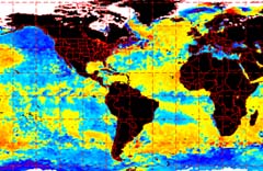
"This warming is an additional sign the Pacific Ocean is heading toward an El Niño condition," said NOAA Administrator and Under Secretary of Commerce for Oceans and Atmosphere VADM Conrad C. Lautenbacher, USN (Ret.). "It's still too early to determine the potential strength of this El Niño or exactly what weather conditions it will bring to the United States, but it is likely these warming conditions in the tropical Pacific will continue until early 2003." Other indicators have corroborated the current forecast. Peruvian officials indicate the ocean warming has had significant impacts on the fishing industry in the region. Their cold-water anchovies have been replaced by tropical species. Similar changes have been observed in early stages of previous El Niño episodes. El Niño conditions occur once water temperatures have warmed sufficiently enough to alter the normal patterns of cloudiness and rainfall in the tropical Pacific basin. A typical El Niño features persistent, increased precipitation along the equator near the international date line, and warmer-than-normal sea-surface temperatures (0.5 C or more above normal) extending eastward to the South American coast. NOAA's advanced global climate monitoring system is instrumental in forecasting El Niño. The system includes NOAA's polar-orbiting satellites and the TAO/TRITON (Tropical Atmospheric-Ocean) Buoy Array, consisting of about 70 moored buoys spanning the equatorial Pacific Ocean. Both provide atmospheric and oceanographic data in real-time. "These observations allow us to get real-time information on sea-surface temperatures as well as ocean subsurface temperatures," said NOAA's National Weather Service Director Brig. Gen. Jack Kelly USAF (ret.). "Since the subsurface temperatures usually warm prior to the development of an El Niño, real-time subsurface information is crucial for timely and accurate predictions." El Niño episodes occur roughly every four-to-five years and can last up to 12-to-18 months. It has been nearly four years since the end of the 1997-1998 El Niño, which was followed by three years of La Niña. Typical El Niño impacts on the United States include:
NOAA will continue to monitor
this developing El Niño event and provide monthly updates. Relevant Web Sites ENSO Frequently Asked Questions Sea Surface Temperature Outlook
|