| NOAA Magazine || NOAA Home Page |
NOAA GETS U.S. CONSENSUS FOR EL NIÑO/LA NIÑA INDEX, DEFINITIONS
 Sept.
30, 2003 � El
Niño and La Niña may have fizzled, but for scientists
at NOAA their quest to better understand and define these climatic twins
is a step closer to resolution. After more than a year of study, NOAA
announced today that it has reached a consensus among experts in the
federal government and academia for an operational index and definitions
for El Niño and La Niña, which are extremes of the El
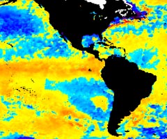
Niño/Southern Oscillation (ENSO) cycle. (Click the NOAA
satellite image for larger view of El Niño taken Jan. 6, 2003.
The warm sea surface temperatures in the eastern Pacific Ocean are represented
in red. Please credit “NOAA.”)
NOAA, in collaboration with experts at the Scripps Institute of Oceanography, the Center for Ocean-Land-Atmosphere Studies, the Center for Ocean-Atmospheric Prediction Studies, the International Research Institute for Climate Prediction, the National Center for Atmospheric Research, and the University of Washington, has agreed on a primary index for assessing the state of the ENSO cycle. Based on the index, NOAA has developed operational definitions for El Niño and La Niña.
“Before now, no widely accepted operational definition of El Niño or La Niña existed,” said retired Navy Vice Admiral Conrad C. Lautenbacher, Jr., Ph.D., undersecretary of commerce for oceans and atmosphere and NOAA administrator. “This effort provides for greater consistency of communication between scientists, who monitor and study the ENSO cycle and more uniformity in our message to the public through the media,” he added.
The index is defined as three-month averages of sea surface temperature departures from normal for a critical region of the equatorial Pacific (Nino 3.4 region; 120W-170W, 5N-5S). This region of the tropical Pacific contains what scientists call the “equatorial cold tongue,” a band of cool water that extends along the equator from the coast of South America to the central Pacific Ocean. Departures from average of sea surface temperatures in this region are critically important in determining major shifts in the pattern of tropical rainfall, which influence the jet streams and patterns of temperature and precipitation around the world.
NOAA’s operational definitions for El Niño and La Niña, based on the index, are:
El
Niño: A phenomenon in the equatorial Pacific Ocean characterized
by a positive sea surface temperature departure from normal (for the
1971-2000 base period) in the Niño 3.4 region greater than or
equal in magnitude to 0.5 degrees C, averaged over three consecutive
months.
La Niña: A phenomenon in the equatorial Pacific
Ocean characterized by a negative sea surface temperature departure
from normal (for the 1971-2000 base period) in the Niño 3.4 region
greater than or equal in magnitude to 0.5 degrees C, averaged over three
consecutive months.
NOAA began using the index and definitions operationally for monitoring and predicting El Niño and La Niña conditions on September 1, 2003. NOAA issues assessments of ENSO’s status in the Monthly Climate Diagnostic Bulletin, the ENSO Diagnostic Discussion, and the Weekly ENSO update. Currently, NOAA is engaged in dialogue with the international meteorological community for global acceptance of the index and definitions.
NOAA is dedicated to enhancing economic security and national safety through the prediction and research of weather and climate-related events and providing environmental stewardship of the nation�s coastal and marine resources. NOAA is part of the U.S. Department of Commerce.
Relevant Web Sites
NOAA
El Ni�o/Southern Oscillation (ENSO) Discussion
NOAA Climate Prediction Center
Media
Contact:
Carmeyia Gillis, NOAA Climate Prediction Center,
(301) 763-7000 ext. 7163