|
|
Tropical Cyclone Products from DMSP
|
 Hurricane images are from the Defense Meteorological Satellite Program (DMSP) Operational Linescan System (OLS). DMSP operates day/night and dusk/dawn satellites. Daytime images are taken with sunlight striking perpendicular to the storm while dusk/dawn images have sunlight glancing across the top of the storm. Images from F12 and F14 are daytime images; those from the F13 satellite are dawn/dusk. Each hurricane is shown in two separate images showing views in the OLS visible near-infrared band and the OLS thermal-infrared band. The spatial resolution of the imagery used is 2.7 km. The thermal infrared images show the temperatures of the cloud tops, and ocean and land surfaces, while the visible-near infrared images show reflected sunlight during the day and reflected moonlight or man-made lights during the night.
Slide Sets
1998
1997
1996
1995
Posters
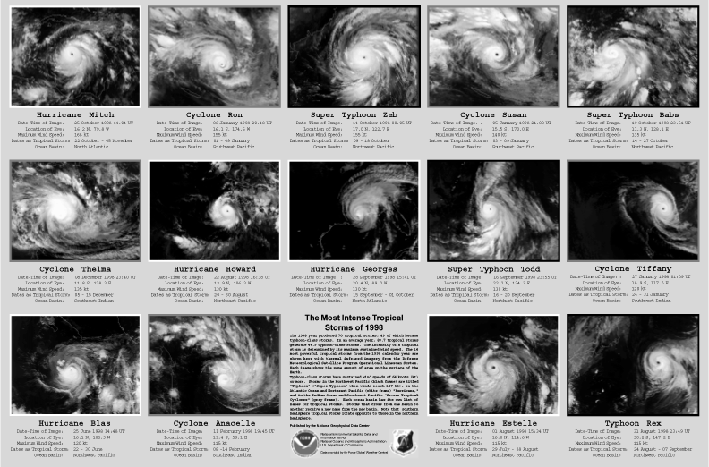
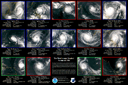
 The Most Intense Tropical Storms of 1998 Poster is 36X24, black and white. The 14 most intense tropical storms from the 1996 calendar year are shown with thermal infrared imagery from the DMSP Operational Linescan System. Although 1998 produced fewer tropical storms than the average, the storms were particularly intense. The destructive power of these storms was evident in the aftermath of Hurricane Mitch. Thousands of lives and homes were destroyed by flooding, landslides and wind. The roster of most intense tropical storms includes 4 typhoons, 5 cyclones, and 5 hurricanes. Each image is accompanied by the vital statistics of the storm, including maximum wind speed, date and time of the image, latitude and longitude of the eye, and duration of the storm.
Purchase the 1998 Tropical Storms Poster
The Most Intense Tropical Storms of 1998 Poster is 36X24, black and white. The 14 most intense tropical storms from the 1996 calendar year are shown with thermal infrared imagery from the DMSP Operational Linescan System. Although 1998 produced fewer tropical storms than the average, the storms were particularly intense. The destructive power of these storms was evident in the aftermath of Hurricane Mitch. Thousands of lives and homes were destroyed by flooding, landslides and wind. The roster of most intense tropical storms includes 4 typhoons, 5 cyclones, and 5 hurricanes. Each image is accompanied by the vital statistics of the storm, including maximum wind speed, date and time of the image, latitude and longitude of the eye, and duration of the storm.
Purchase the 1998 Tropical Storms Poster
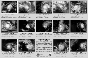
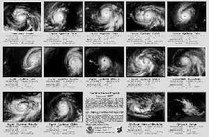 The Most Intense Tropical Storms of 1997 Poster is 36X24, black and white. The 14 most intense tropical storms from the 1996 calendar year are shown with thermal infrared imagery from the DMSP Operational Linescan System. This poster includes images and information for 10 typhoons, 2 cyclones, and 2 hurricanes. Hurricanes Linda and Guillermo were the only western-hemisphere storms to surpass 128 knots average wind speed. Super Typhoon Paka lasted a rarely seen duration of twenty days. Cyclone Pancho-Helinda travelled nearly the entire width of the Indian Ocean. Each image is accompanied by the vital statistics of the storm, including maximum wind speed, date and time of the image, latitude and longitude of the eye, and duration of the storm.
Purchase the 1997 Tropical Storms Poster
The Most Intense Tropical Storms of 1997 Poster is 36X24, black and white. The 14 most intense tropical storms from the 1996 calendar year are shown with thermal infrared imagery from the DMSP Operational Linescan System. This poster includes images and information for 10 typhoons, 2 cyclones, and 2 hurricanes. Hurricanes Linda and Guillermo were the only western-hemisphere storms to surpass 128 knots average wind speed. Super Typhoon Paka lasted a rarely seen duration of twenty days. Cyclone Pancho-Helinda travelled nearly the entire width of the Indian Ocean. Each image is accompanied by the vital statistics of the storm, including maximum wind speed, date and time of the image, latitude and longitude of the eye, and duration of the storm.
Purchase the 1997 Tropical Storms Poster
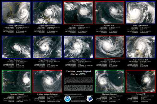
 The Most Intense Tropical Storms of 1996 Poster is 36X24, color. The 14 most intense tropical storms from the 1996 calendar year are shown with thermal infrared imagery from the DMSP Operational Linescan System. Each image is accompanied by the vital statistics of the storm, including maximum wind speed, date and time of the image, latitude and longitude of the eye, and duration of the storm. The roster of most intense tropical storms includes 7 typhoons, 5 cyclones, and 2 hurricanes.
Purchase the 1996 Tropical Storms Poster
The Most Intense Tropical Storms of 1996 Poster is 36X24, color. The 14 most intense tropical storms from the 1996 calendar year are shown with thermal infrared imagery from the DMSP Operational Linescan System. Each image is accompanied by the vital statistics of the storm, including maximum wind speed, date and time of the image, latitude and longitude of the eye, and duration of the storm. The roster of most intense tropical storms includes 7 typhoons, 5 cyclones, and 2 hurricanes.
Purchase the 1996 Tropical Storms Poster
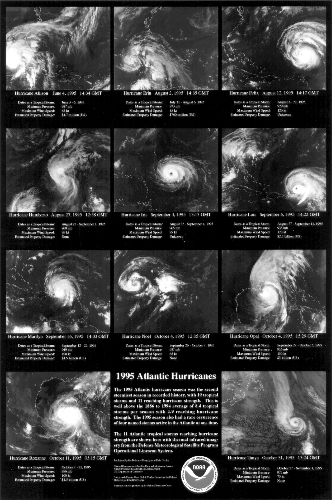
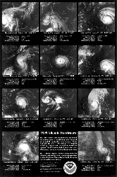 The 1995 Atlantic Hurricanes Poster is 24X36, black and white. The 11 hurricanes from 1995's active season in the Atlantic are shown using thermal infrared imagery from the DMSP Operational Linescan System. Each image is accompanied by the vital statistics of the storm, including maximum wind speed, date and time of the image, latitude and longitude of the eye, estimated damage is US dollars, and duration of the storm.
Purchase the 1995 Atlantic Hurricanes Poster
The 1995 Atlantic Hurricanes Poster is 24X36, black and white. The 11 hurricanes from 1995's active season in the Atlantic are shown using thermal infrared imagery from the DMSP Operational Linescan System. Each image is accompanied by the vital statistics of the storm, including maximum wind speed, date and time of the image, latitude and longitude of the eye, estimated damage is US dollars, and duration of the storm.
Purchase the 1995 Atlantic Hurricanes Poster
|
|