|
Extended Continental Shelf Project Data ManagementData Management and the ECSThe process to determine the outer limits of the ECS requires the analysis of data that describe the depth, shape, and geophysical characteristics of the seabed and sub-sea floor, as well as the thickness of the underlying sediments. The specific types of data that need to be analyzed include bathymetric data, seismic profiles, and other geophysical data including deep-sea cores, and magnetic and gravity data. In 2007, the U.S. Extended Continental Shelf (ECS) Project, directed by an interagency task force, identified NGDC as the center supporting analysis and responsible for archive of all ECS data and information. The U.S. ECS Task Force sponsored a Workshop on ECS Data and Information Management in October 2007. The workshop included representatives from Department of State, NOAA, USGS, MMS, NGA, Arctic Research Commission, and academia. This 3-day effort, discussed data requirements and needs, potential areas of new data collection, was a first step in developing an ECS data management plan and resulted in the following recommendations from the U.S. ECS Task Force:
In 2001 Congress directed the Joint Hydrographic Center/Center for Coastal and Ocean Mapping at the University of New Hampshire to make a report to Congress evaluating current data holdings relevant to establishing the U.S. ECS, and to recommend the additional data that would be needed to substantiate an ECS delimitation. This study focused on existing sources and their applicability to an ECS delimitation. 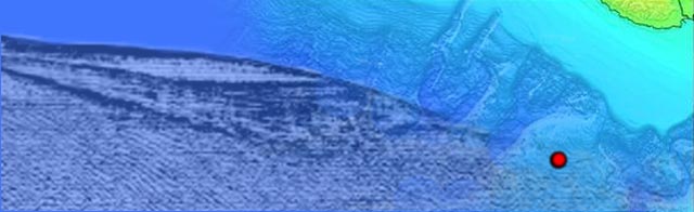
Figure 1: Seismic reflection, bathymetry, and borehole data are all useful in delimiting an ECS. |