2-Minute Gridded Global Relief Data (ETOPO2v2)
|
| Order DVD-ROM | Free On-line: images, custom grids, data (access latest relief model) |
The June 2006 ETOPO2v2 data structure, provenance changes and updates
(Differences from the 2001 version of ETOPO2) are:
-
First and foremost, ETOPO2v2 eliminates a 1-cell westward bias that was present in ETOPO2 (2001).
-
ETOPO2v2 is now available in both a downloadable cell-centered version, named ETOPO2v2c (pixel registered, where the cell boundaries are lines of even minutes of latitude and longitude, centered on intersections of lines of odd minutes of latitude and longitude) and a grid-centered, version, available via design-a-grid (with cell boundaries defined by lines of odd minutes of latitude and longitude, meaning that cells were centered on the integer multiples of 2 minutes [even minutes] of latitude and longitude). The cell-centered grid is the authoritative version. The grid-centered version was derived from the cell-centered grid and the conversion produces slightly flattened relief. This is a change from the original ETOPO2 (2001), which was available as grid-registered only.
-
Coverage of ETOPO2v2 is -90° to +90° in Latitude, and -180° to +180° in Longitude, whereas ETOPO2 (2001) covered +90° to -89°58' in Latitude and -180W° to +179°58' in Longitude.
The ETOPO2v2c, with cell centered-registration, eliminates the ETOPO2 North Pole redundancies but has the same number of cells: 5,400 rows of data (180 x 30), each with 10,800 columns of data (360x30). The first row of 10,800 (360 x 30) cells in ETOPO2 (2001) redundantly repeated the same data value, centered on the north pole. A data row, centered on the South Pole, was not included in the original ETOPO2 (2001).
-
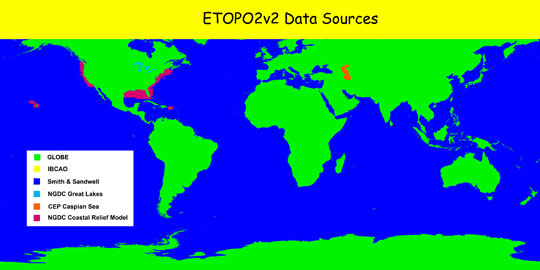
Land topography was re-sampled from the GLOBE Project (1999) to ensure proper registration with the 2' ETOPO2v2 grid.
-
Bathymetry data for the Caspian Sea were obtained as digitized contours from the Caspian Environment Programme website at http://www.caspianenvironment.org/dim/menu5.htm.
-
For coastal US waters, the NGDC Coastal Relief Model (CRM) 3" grids from CRM Volumes 1-10 were sampled to 2' cell averages for bathymetry.
-
Great Lakes bathymetry data were sampled to 2' cell averages from 3" NGDC source grids for Lakes Erie, Ontario, Huron, and Michigan; preliminary 30" source data were used for Lake Superior.
ETOPO2v2 Sources
Data Sources:
Smith & Sandwell
The "Smith & Sandwell" database is a worldwide set of 2-minute gridded ocean bathymetry derived from 1978 satellite radar altimetry of the sea surface. The version contained in ETOPO2v2 is 8.2. For a detailed technical discussion of their methodology.
Click here for more details about the Smith & Sandwell database.
GLOBE
The "Global Land One-kilometer Base Elevation" (GLOBE) database is made up of data sets from more than eight US and foreign agencies. It covers all of the world's land masses at a resolution of 0.5 minute (30") of latitude and longitude, which is approximately one kilometer at the equator. GLOBE data were sampled to 2' cell averages for all land areas.
Click here for more details about GLOBE.
IBCAO
The International Bathymetric Chart of the Arctic Ocean (IBCAO) initiative developed a digital database that contains all available bathymetric data north of 64 degrees North. The version contained in ETOPO2v2 is 1.0, sampled to 2' cell averages.
Click here for more details about IBCAO.
NGDC Coastal Relief Model (CRM)
The Coastal Relief Model (CRM) is used for US waters from the coastline to as far offshore as the NOS hydrographic data will support a continuous view of the seafloor. Data were sampled to 2' cell averages for areas adjacent to all 48 conterminous states, Hawaii, and Puerto Rico.
Click here for more details about the CRM.
NGDC Great Lakes Bathymetric Data
Great Lakes bathymetric data were sampled to 2' cell averages for all five Great Lakes. 3" source grids were available for lakes Huron, Michigan, Erie, and Ontario; preliminary 30" grid data were sampled for Lake Superior. All lake depth data were made consistent with surrounding land elevations and each lake's mean level datum.
Click here for more details about Great Lakes Bathymetry.
Caspian Sea Bathymetry
Bathymetry data for the Caspian Sea were obtained as digitized depth contours from the Caspian Environment Programme website. The digitized contours were analyzed with surface-fitting software to produce a digital bathymetric grid registered to the same coordinate system as the rest of ETOPO2v2, and made consistent with the surrounding land elevations -- the surface of the Caspian Sea is approximately 29m below Mean Sea Level.
Click here for more details about Caspian Sea Bathymetry.
