
|
||||

|
NCDC | Climate | Products | Events | Search | Help
|
| Hurricane | Date | Areas Struck | Deaths |
|---|---|---|---|
| "The Great Hurricane" | October 10-16, 1780 | Martinique St. Eustatius Barbados Ships |
22,000 |
| Hurricane Mitch | Oct 26 - Nov 4, 1998 | Central America: Honduras Nicaragua |
11,000+ |
| Galveston, Texas | September 8, 1900 | Galveston Island | 8,000 |
| Hurricane Fifi | September 14 -19, 1974 | Honduras | 8,000 |
| Dominican Republic | September 1-6, 1930 | Dominican Republic | 8,000 |
| Hurricane Flora | Sep 30, 1963 - Oct 8, 1963 | Haiti Cuba |
7,200 |
| Martinique | September 6, 1776 | Point Petre Bay | 6,000 |
Reference:
1995: Rappaport, Edward N. and Fernandez-Partagas, Jose; "The Deadliest Atlantic Tropical Cyclones, 1492-1994," NOAA Technical Memorandum NWS NHC-47, National Hurricane Center, 41 pp.
Within four days of its birth as a tropical depression on October 22, Mitch had grown into a Category 5 storm on the Saffir-Simpson Hurricane Scale. By 2100 UTC on October 26, the monster storm had deepened to a pressure of 905 millibars with sustained winds of 155 knots (180 mph) and gusts well over 200 mph! Mitch thus became tied for the fourth strongest Atlantic hurricane on record based upon barometric pressure values. Though the pressure began rising six hours later, Mitch remained at Category 5 status for a continuous period of 33 hours - the longest continuous period for a Category 5 storm since the 36 consecutive hours by Hurricane David in 1979. In addition, Mitch maintained sustained winds of 155 knots for 15 hours - the third longest period of such winds on record after the continuous 18 hours of 155 knot winds or higher by Hurricane Camille in 1969 and Hurricane Dog in 1950. Though exact comparisons are suspect due to differing frequencies in observation times (3-hourly versus 6-hourly observations) and a bias in earlier years toward higher estimated wind speeds, it is quite apparent that Mitch was one of the stronger storms ever recorded in the Atlantic. Table 2 provides historical information on the strongest hurricanes ever recorded in the Atlantic Basin, which includes the Gulf of Mexico and the Caribbean Sea.
Table 2 - Strongest Atlantic Hurricanes on Record
| Hurricane | Date | Pressure | Peak Winds | Total no. of hours at Cat 5 |
Total no. of hours winds 155+ knots |
|---|---|---|---|---|---|
| Gilbert | Sep 13, 1988 | 888 mb (26.22 in) |
160 knots | 18 hours | 6 hours |
| Florida Keys | Sep 3, 1935 | 892 mb (26.34 in) |
140 knots | 3 hours | 0 hours |
| Allen | Aug 7, 1980 | 899 mb (26.55 in) |
165 knots | 24 / 24 /12 hours* | 3 / 12 / 3 hours* |
| Mitch | Oct 26, 1998 | 905 mb (26.73 in) |
155 knots | 33 hours | 15 hours |
| Camille | Aug 17, 1969 | 905 mb (26.73 in) |
165 knots | 24 hours | 18 hours |
* Hurricane Allen attained Category 5 status three times during its life history: first on August 5, second on August 7, and third on August 9.
After threatening Jamaica and the Cayman Islands, Mitch moved westward and by 2100 UTC on October 27, the Category 5 storm was about 60 miles north of Trujilo on the north coast of Honduras. Preliminary wave height estimates north of Honduras during this time at the height of the hurricane are as high as 44 feet, according to one wave model. Although its ferocious winds began to abate slowly, it took Mitch two days to drift southward to make landfall. Coastal regions and the offshore Honduran island of Guanaja were devastated. Mitch then began a slow westward drift through the mountainous interior of Honduras, finally reaching the border with Guatemala two days later on October 31.
Although the ferocity of the winds decreased during the westward drift, the storm produced enormous amounts of precipitation caused in part by the mountains of Central America. As Mitch's feeder bands swirled into its center from both the Caribbean and the Pacific Ocean to its south, the stage was set for a disaster of epic proportions. Taking into account the orographic effects by the volcanic peaks of Central America and Mitch's slow movement, rain fell at the rate of a foot or two per day in many of the mountainous regions. Total rainfall has been reported as high as 75 inches for the entire storm. The resulting floods and mud slides virtually destroyed the entire infrastructure of Honduras and devastated parts of Nicaragua, Guatemala, Belize, and El Salvador. Whole villages and their inhabitants were swept away in the torrents of flood waters and deep mud that came rushing down the mountainsides. Hundreds of thousands of homes were destroyed.
The remnants of Mitch drifted northwestward as a weak depression and entered the Bay of Campeche on November 2. Over the warm waters and favorable conditions aloft, Mitch once more regained tropical storm status and began moving rapidly northeastward. It struck the western side of Mexico's Yucatan Peninsula which weakened it to tropical depression status once again. As Mitch moved back over the Gulf of Mexico, it regained tropical storm status for the third time. It raced northeastward and pounded Key West with tropical storm force winds and heavy rains on November 4-5. Some of the roofs and buildings damaged by Hurricane Georges in September fell victim to Mitch. Rains of six to eight inches were common in southern Florida and several tornadoes struck the region. At least 7 were injured when a tornado swept from Marathon to Key Largo. A second tornado touched down at Miramar north of Miami. At Fowey Rocks Lighthouse, just southeast of Miami, a wind gust of 73 mph was reported. Across south Florida, some 100,000 customers lost electrical power. One person was killed in the U.S. near Dry Tortugas when a fisherman died from a capsized boat. A second person was missing. Another person died as a result of an auto accident on a slick highway. Mitch passed through the Bahamas and finally became extratropical on November 5.
 Damage Synopsis by Country
Table 3 - Preliminary Mitch Casualty Reports
| Country | Deaths | Missing | Damage |
|---|---|---|---|
| Honduras | 6500 | 4600 - 11,000(?) | $4 billion |
| Nicaragua | 3800 | 7,000 (?) | $1 billion |
| El Salvador | 239 | 130 | ? |
| Guatemala | 256 | ? | ? |
| Mexico | 9 | 0 | ? |
| Costa Rica Jamaica Panama U.S. |
7 3 3 1 |
0 | ? |
| Schooner "Fantome" | 31 | 0 | ? |
| Total | 11,000 | 11-18,000 ? | $5 billion + |
Following are reports of the damage and destruction left by Mitch from each country affected:
HONDURAS:
Entire country affected.
Human toll:
An estimated 6,500 dead with up to 11,000 still missing. Up to 1.5 million people displaced and homeless. Critical food, medicine, and water shortages. Hunger and near-starvation widespread in many villages. Epidemics feared as malaria, dengue, and cholera make appearance. Fever and respiratory illnesses widespread. Helicopters required to take supplies to areas cut off by floods, but were in short supply. Some survivors still reported clinging to roof tops, and isolated areas of Honduras had not received help as late as November 12. At least 20% of country's population now homeless. Many of the unidentified dead were being buried in mass graves or their bodies were cremated. Tegucigalpa Mayor Cesar Castellanos, a likely candidate for Honduras' presidency in elections in 2001, and three others were killed when their helicopter crashed while surveying flood damage on Sunday, November 1. On Wednesday, November 4, the U.S. Coast Guard called off its search for the schooner "Fantome" after debris and life jackets were found. Thirty-one members of the crew were presumed lost after the captain tried to shield the boat from Mitch by sailing south of Guanaja Island. The last contact from the ship was on October 27.
Structural damage:
Infrastructure devastated. Whole villages washed away. Estimated 70 - 80 percent of transportation infrastructure destroyed. The majority of the country's bridges and secondary roads washed away. Even airports were under water. Helicopters were required for most rescues and aid because of transportation difficulties; communications disrupted. Fuel, electricity and running water scarce commodities. Damage so severe it may take 15 years to 20 years or more to rebuild. Some buildings 350 years old in capital city of Tegucigalpa were reported to be washed away completely. One third of all buildings in the capital were damaged by the floods. In outlying areas, over 25 small villages in the northern part of the country were swept away. Survivors were still clinging to roof tops a week or more after the storm. Heavy damage along coastline and off-shore islands from storm surge and hurricane-force winds. Severe damage inflicted on tourist resorts. Damage estimates of four billion dollars in Honduras alone.
Crop damage:
At least 70 percent of crops destroyed, including 80 percent of the banana crop. Crop losses estimated at $900 million. Large warehouses and storage rooms for coffee flooded. Maize and corn crops devastated. The damage by Mitch to Honduran agricultural production will take years for recovery.
NICARAGUA:
Northwest parts and northern parts of country most affected.
Human toll:
An estimated 3800 dead with perhaps as many as 7,000 others still missing. Two million people directly affected and 500,000 - 800,000 homeless. Intense near-stationary rain bands over western Nicaragua on Thursday and Friday (October 29-30) caused tens of inches of rain to fall. The crater lake atop the dormant Casita volcano filled and part of the walls collapsed on Friday, October 30, causing mud flows that eventually covered an area ten miles long and five miles wide. At least four villages were totally buried in the mud that was several feet deep. Over 2,000 of the dead were from the areas around the collapsed volcano near Posoltega. In many cases, survivors had to wait days before the mud had dried enough to walk to rescuers. Damage was extensive from flooding in other parts of the country, also. As late as November 8, over a thousand people were in urgent need of supplies on the Coco River near the border with Honduras. Earlier, on Thursday, November 5, five hundred bodies were found in the same river near the town of Wiwili. An additional five hundred unidentified bodies had washed up on the Pacific shore after flood waters had washed their bodies out to sea. As with Honduras, there were critical food and water shortages in flooded areas.
Structural damage:
Infrastructure in affected regions devastated. Several villages buried under mud slides near the Casita Volcano. Damage estimates for Nicaragua are at $1 billion. Damage considered worse than in the 1972 Managua earthquake. Damage to a half million homes and 750,000 people lost their homes or possessions.
Crop damage:
Thirty percent of coffee crop destroyed according to preliminary reports. Beans, sugar, and banana crops devastated.
Other Countries:
El Salvador: Western part of country most affected by rain bands spiralling into Mitch from the Pacific Ocean. 230 dead. 500,000 forced from their homes by flooding. As much as 80% of maize crop lost. Coffee plantations and sugar cane crop severely affected.
Guatemala: Over 200 killed by floods. Ten U.S. citizens and one other person killed in plane crash supplying humanitarian aid on Sunday, November 1. Near 80,000 evacuated from their homes by flooding. Nearly 1 million directly affected by Mitch. Extensive damage to coffee and banana plantations.
Costa Rica: Seven reported killed by flooding, mostly in the northeastern part of the country. Few thousand forced from their homes.
Belize: Eleven dead or missing. Flood and crop damage extensive. Most of Belize City evacuated on October 28 as Mitch threatened to hit the city as at least a Category 4 storm. Had this occurred, it might have been similar to the Hurricane Hattie disaster of October 31, 1961 when Belize City was virtually destroyed and as a result the capital was moved inland to Belmopan. With Mitch stalling well east of Belize City, the disaster was not repeated and most of Mitch's damage was from flooding.
Mexico: Nine reported killed. Five died near Tapachula in southern Mexico near the Guatemalan border when their car was washed from the road. A U.S. citizen was killed near Cancun in a boating accident. Though ocean swells hit the Mexican tourist meccas of Cancun and Cozumel, they were largely unaffected. Many tourists cancelled reservations, however, when it appeared Mitch was poised to strike the Yucatan.
Former Presidents George W. Bush and Jimmy Carter visited the region and called for re-structuring and scaling back of international debt owed by Honduras and Nicaragua. As a direct result of the disaster, the International Monetary Fund began considering the formation of an emergency fund to help countries hit by natural disasters. The United States announced on Thursday, November 5, that it would supply $70 million in aid for Central America, and on November 10, an additional $10 million was added. Spain reported it would provide $105 million in aid and Sweden announced it would provide $100 -$200 million over a three year period. In addition, tons of food and grain were flown in by humanitarian organizations. Mexico provided an airlift of urgently needed supplies, and European countries donated $8 million. Canada supplied over $7 million in assistance. Additional help came from Japan and other countries.
Central American Hurricanes
Table 4 - Noteworthy Central American Hurricanes (Since 1950)
| Name/ Date |
Landfall | Lowest Pressure | Wind | Deaths | Damage |
|---|---|---|---|---|---|
| Mitch Oct 27-29, 1998 |
Offshore Trujilo, Hond. |
917 mb 990 mb |
180 mph 75 mph |
Total: 11,000 Honduras: 6500 Nicaragua: 3800 El Salvador: 239 Guatemala: 256 Other: 54 |
$5 billion+ |
| Cesar July 27, 1996 |
Bluefields, Nicaragua | 985 mb | 85 mph | Total: 51 Costa Rica: 26 |
NA |
| Joan October 22, 1988 |
Bluefields, Nicaragua | 932 mb Bluefields |
145 mph | Total: 216 Nicaragua: 148 Coasta Rica: 28 Columbia: 25 Venezuela: 11 Panama: 4 |
$2 Billion Total Nicaragua:$1 Billion |
| Greta September 17, 1978 September 19, 1978 |
Nr Puerto Lempira, Honduras Nr Stann Creek, Belize |
NA | Honduras: 80 mph / G 115 mph | Belize: 4 Honduras: 1 |
NA |
| Fifi September 18, 1974 September 19, 1974 |
La Ceiba, Honduras southern Belize |
NA | La Ceiba: 100 mph Belize: 100 mph |
Honduras: 3,000 - 8,000 | NA |
| Carmen September 2, 1974 |
Chetumal, Mexico (Yucatan) | 956 mb | 135 mph | - | - |
| Edith September 9, 1971 September 10, 1971 |
Cape Gracias, Nicaragua Belize |
Nicaragua: 943 mb | Nicaragua: 160 mph | Nicaragua: 35 | NA |
| Francelia September 3, 1969 |
NA | 991 mb | 110 mph | Guatemala: 100 | $4.7 Million |
| Hattie October 31, 1961 |
20 m s Belize City | 924 mb Belize |
E 150- 160 mph | Belize: 262 Honduras: 11 San Andres Island: 1 Honduras: 1 |
Belize: $60 million |
| Anna July 24, 1961 |
60 m s of Belize City | NA | E 75 mph | Honduras: 1 | NA |
| Abby July 15, 1960 |
southern Belize | 995 mb | 80 mph | 0 | $600,000 |
| Janet September 28, 1955 |
Chetumal, Mexico | E 914 mb | 175 mph / E 200 mph | Mexico Yucatan: 500 Belize: 16 Grenada: 122 Barbados: 38 Carriacou: 25 |
Mexico: $40 Million Belize: $5 Million |
Satellite Images of Hurricane Mitch
October 27 : 13:00 UTC - Multispectral Colorized Image - Category 5 (917 mb/155 knots)
October 26 : 1445 UTC - Full Earth View - Category 5 (923 mb/135 knots)
October 26: 1815 UTC - Colorized IR at Lowest Pressure - Category 5 (906 mb/145 knots)
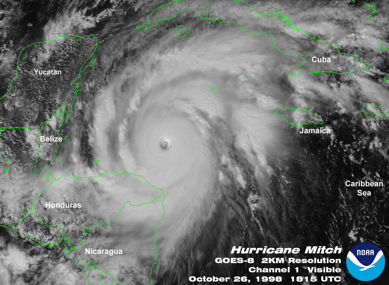
October 26: 1815 UTC - Visible at Lowest Pressure - Category 5 (906 mb/145 knots)
October 26: 1245 UTC - IR After Category 5 Attained - Category 5 (923 mb/135 knots)
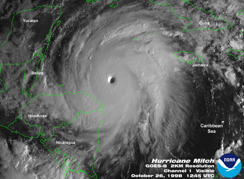
October 26: 1245 UTC - Visible After Category 5 Attained - Category 5 (923 mb/135 knots)
NESDIS Operational Significant Event Imagery
Estimated Precipitation Amounts
Precipitation estimates for Mitch for the total storm event in Honduras and Nicaragua have ranged from 50 to 75 inches for locations receiving the heaviest rainfall. These values are not unreasonable considering the tropical location and the altitude of the mountainous terrain. For example, Hurricane Flora produced similar or even higher precipitation totals over Cuba in 1963. In one incident, Mitch reportedly produced 25 inches of rain in just six hours! With the infrastructure damaged so severely, it is unlikely that actual precipitation measurements for Mitch will be available from many areas. The National Climatic Data Center will attempt to locate satellite-derived estimates or other sources and will report the data as they are received.
Following are Hurricane Mitch preliminary rainfall reports, showing rainfall in affected countries for the 6-day period ending on Oct 31, 1998 - amounts listed for totals of at least 3.00 inches. These totals are based on data received for synoptic stations, which are then summarized into summary of day data, and finally into this table. Note that there were a great deal of missing data, which is typical for this region, but even more so due to the extreme conditions. Many if not all of these stations certainly received higher rainfall totals. Also, rain gauges in more remote mountainous locations (not official reporting stations) reportedly received amounts exceeding 48 inches. Given La Ceiba's report of 24.19 inches at an elevation of only 3 meters, this is not surprising.
STATION = Station number
RAIN = Total reported rainfall (inches) for the 6-day period ending on
       Oct 31.
DAY = Number of days of data for the 6-day period --
       Note that most stations did not report for all possible days
NAME & COUNTRY = Station name and country: HO - Honduras, ES - El
       Salvador, CS - Costa Rica, BH - Belize, NK - Nicaragua
LAT/LON = Latitude and Longitude in degrees and minutes
ELEV = Elevation in meters

STATION  RAIN   DAY  NAME & COUNTRY           LAT     LON     ELEV(M)

787050   24.19   6   LA CEIBA/GOLOSON    HO   1544N   08652W   0003
786500   10.33   5   ACAJUTLA/SONSONATE  ES   1334N   08950W   0015
787070    9.97   4   YORO                HO   1510N   08707W   0670
787180    9.41   6   SOTO CANO AB        HO   1423N   08737W   0626
787060    8.43   1   TELA                HO   1543N   08729W   0003
787030    8.12   3   ROATAN              HO   1619N   08632W   0005
787140    7.32   5   CATACAMAS           HO   1454N   08556W   0442
787620    6.73   5   SAN JOSE/SANTAMARIA CS   1000N   08413W   0931
787080    6.06   4   LA MESA/PEDRO SULA  HO   1527N   08756W   0031
787110    5.72   5   PUERTO LEMPIRA      HO   1513N   08348W   0013
785960    4.25   4   HUNTING CAYE        BH   1606N   08815W   0001
787170    3.12   6   SANTA ROSA DE COPAN HO   1447N   08847W   1079
787410    3.03   5   MANAGUA/AUGUSTO CES NK   1209N   08610W   0050
Additional Information and Links
National Hurricane Center
GOES Satellite Gallery at CIMSS
CNN -Hurricane Mitch Information
Relief Web Agency
NCDC Climatic Extremes and Weather Events
NCDC Hurricanes--Climatology and Reports
Top of Page
http://www.ncdc.noaa.gov/oa/reports/mitch/mitch.html
Downloaded Saturday, 20-Sep-2008 15:18:50 EDT
Last Updated Tuesday, 29-Aug-2006 12:31:54 EDT by Neal.Lott@noaa.gov, Sam.Mccown@noaa.gov, Axel.Graumann@noaa.gov, Tom.Ross@noaa.gov, Mark.Lackey@noaa.gov
Please see the NCDC Contact Page if you have questions or comments.