 |
U.S.Department of Commerce / NOAA / PMEL / TAO / El Niño theme Page |
|
What is an El Niño? |
|||||||||||||||||||||||||||||||||
|
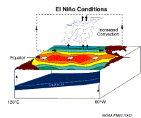
Among these consequences are increased rainfall across the southern tier of the US and in Peru, which has caused destructive flooding, and drought in the West Pacific, sometimes associated with devastating brush fires in Australia. Observations of conditions in the tropical Pacific are considered essential for the prediction of short term (a few months to 1 year) climate variations. To provide necessary data, NOAA operates a network of buoys which measure temperature, currents and winds in the equatorial band. These buoys daily transmit data which are available to researchers and forecasters around the world in real time. In normal, non-El Niño conditions (top panel of schematic diagram), the trade winds blow towards the west across the tropical Pacific. These winds pile up warm surface water in the west Pacific, so that the sea surface is about 1/2 meter higher at Indonesia than at Ecuador.
The sea surface temperature is about 8 degrees C higher in the west, with cool temperatures off South America, due to an upwelling of cold water from deeper levels. This cold water is nutrient-rich, supporting high levels of primary productivity, diverse marine ecosystems, and major fisheries. Rainfall is found in rising air over the warmest water, and the east Pacific is relatively dry. The observations at 110 W (left diagram of 110 W conditions) show that the cool water (below about 17 degrees C, the black band in these plots) is within 50m of the surface. During El Niño (bottom panel of the schematic diagram), the trade winds relax in the central and western Pacific leading to a depression of the thermocline in the eastern Pacific, and an elevation of the thermocline in the west. The observations at 110W show, for example, that during 1982-1983, the 17-degree isotherm dropped to about 150m depth. This reduced the efficiency of upwelling to cool the suface and cut off the supply of nutrient rich thermocline water to the euphotic zone. The result was a rise in sea surface temperature and a drastic decline in primary productivity, the latter of which adversely affected higher trophic levels of the food chain, including commercial fisheries in this region. The weakening of easterly tradewinds during El Niño is evident in this figure as well. Rainfall follows the warm water eastward, with associated flooding in Peru and drought in Indonesia and Australia. The eastward displacement of the atmospheric heat source overlaying the warmest water results in large changes in the global atmospheric circulation, which in turn force changes in weather in regions far removed from the tropical Pacific. Recognizing El Niño
El Niño can be seen in measurements of the sea surface temperature, such as those shown above, which were made from the TAO Array of moored buoys. In December 1993, the sea surface temperatures and the winds were near normal, with warm water in the Western Pacfic Ocean (in red on the top panel of December 1993 plot), and cool water, called the "cold tongue" in the Eastern Pacific Ocean (in green on the top panel of the December 1993 plot). The winds in the Western Pacific are very weak (see the arrows pointing in the direction the wind is blowing towards), and the winds in the Eastern Pacific are blowing towards the west (towards Indonesia). The bottom panel of the December 1993 plot shows anomalies, the way the sea surface temperature and wind differs from a normal December. In this plot, the anomalies are very small (yellow/green), indicating a normal December. December 1997 was near the peak of a strong El Niño year. In December 1997, the warm water (red in the top panel of the December 1997 plot) has spread from the western Pacific Ocean towards the east (in the direction of South America), the "cold tongue" (green color in the top panel of the December 1997 plot) has weakened, and the winds in the western Pacific, usually weak, are blowing strongly towards the east, pushing the warm water eastward. The anomalies show clearly that the water in the center of Pacific Ocean is much warmer (red) than in a normal December. December 1998 was a strong La Niña (cold) event. The cold tongue (blue) is cooler than usual by about 3° Centigrade. The cold La Niña events sometimes (but not always) follow El Niño events. Animation of El Niño If you have an MPEG animation viewer, and sufficient memory, you can view an animation of El Niño which shows the changes in monthly sea surface temperature in the tropical Pacific Ocean. The animation is about 1 Megabyte in size. As you view this animation, you will see the warm water spreading from the western Pacific to the eastern Pacific during 1997. The bottom panel in the animation, labeled anomalies, shows how much the sea surface temperature for each month is different from the long term average for that month. The red color in the anomalies plot indicates that the temperature of the water is much warmer than is normal for that month. Blue color indicates that the water is much cooler than is normal for that month Recent El Niños
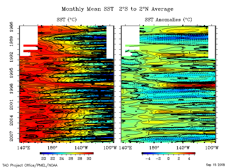
In the left hand panel, you see the sea surface temperature at the Equator in the Pacific Ocean (Indonesia is towards the left, South America is towards the right). Time is increasing downwards from 1986 at the top of the plot, to the present, at the bottom of the plot. The first thing to note is the blue "scallops" on the right of the plot, in the eastern Pacific. These indicate the cool water typically observed in the Eastern Pacific (called the "cold tongue"). Cold tongue temperatures vary seasonally, being warmest in the northern hemisphere springtime and coolest in the northern hemisphere fall. The red color on the left is the warm pool of water typically observed in the western Pacific Ocean. El Niño is an exaggeration of the usual seasonal cycle. During the El Niño in 1986-1987, you can see the warm water (red) penetrating eastward in the Spring of 1987. There is another El Niño in 1991-1992, and you can see the warm water penetrating towards the east in the northern hemisphere spring of 1992. The El Niño in 1997-1998 is a very strong El Niño. El Niño years are easier to see in the anomalies on the right hand panel. The anomalies show how much the sea surface temperature is different from the usual value for each month. Water temperatures significantly warmer than the norm are shown in red, and water temperatures cooler than the norm are shown in blue.
In the right-hand plot of sea surface temperature anomalies, it is very easy to see El Niños, with water warmer than usual (red) in the eastern Pacific, during in 1986-1987, 1991-1992, 1993, 1994 and 1997-1998. Notice the very cool water (blue), in the Eastern Pacific, in 1988-1989. This is a strong La Niña, which occurs after some (but not all) El Niño years. 1995-1996 was a weaker La Niña year. It is unusual for El Niños to occur in such rapid succession, as has been the case during 1990-1994. Selected
references National Academy of Sciences El Niño web site Philander, S.G.H., 1990: El Niño, La Niña and the Southern Oscillation. Academic Press, San Diego, CA, 289 pp. Hayes, S.P., L.J. Mangum, J. Picaut, A. Sumi, and K. Takeuchi, 1991: TOGA-TAO: A moored array for real-time measurements in the tropical Pacific Ocean. Bull. Am. Meteorol. Soc., 72, 339-347. (abstract available) McPhaden, M.J., 1993: TOGA-TAO and the 1991-93 El Niño-Southern Oscillation Event. Oceanography, 6, 36-44. (entire paper available) El Niño references: TAO
refereed journal articles and other
TAO papers. Reports to the Nation - El
Niño and Climate Prediction |
|||||||||||||||||||||||||||||||||
|
Disclaimer | Privacy
Policy |
|||||||||||||||||||||||||||||||||


