
 Atom Feed
 Google Earth KML
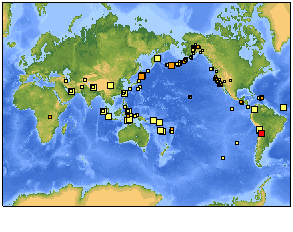
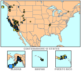
Click maps for more information
Latest Earthquakes

World (Magnitude 4+)
Tue Sep 16 00:35:24 GMT

USA (Magnitude 1+)
Tue Sep 16 00:35:03 GMT
Today's Earthquake Fact
The Wasatch Range, with its outstanding ski areas, runs North-South through Utah, and like all mountain ranges, was produced by a series of earthquakes. The 386 km (240-mile) long Wasatch Fault is made up of several segments, each capable of producing up to a M7.5 earthquake. During the past 6000 years, there has been a M6.5+ about once every 350 years, and it has been 150 years since the last powerful earthquake.
