
March 1997 Tornadoes and Flooding
|
|
NCDC | Contents | Climate | Products | Events | Search | Help
|
|||||||||||||||||||||||
 Satellite Visible Arkadelphia Tornado (387KB) |
 Satellite Visible Sardis Tornado (384KB) |
 Visible MPEG AR Tornadoes (695KB) |
 IR MPEG AR Tornadoes (695KB) |
 Regional IR March 1 0915Z March 1 2115Z March 2 0915Z (220KB) |
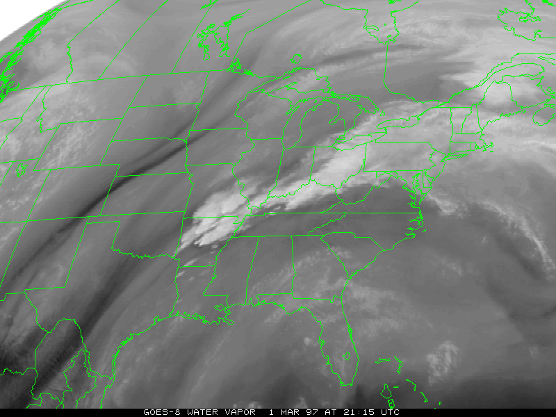
 Regional Water Vapor March 1 0915Z March 1 2115Z March 2 0915Z (125KB) |
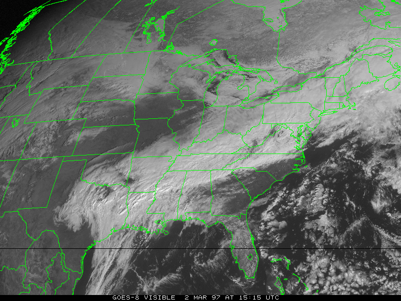
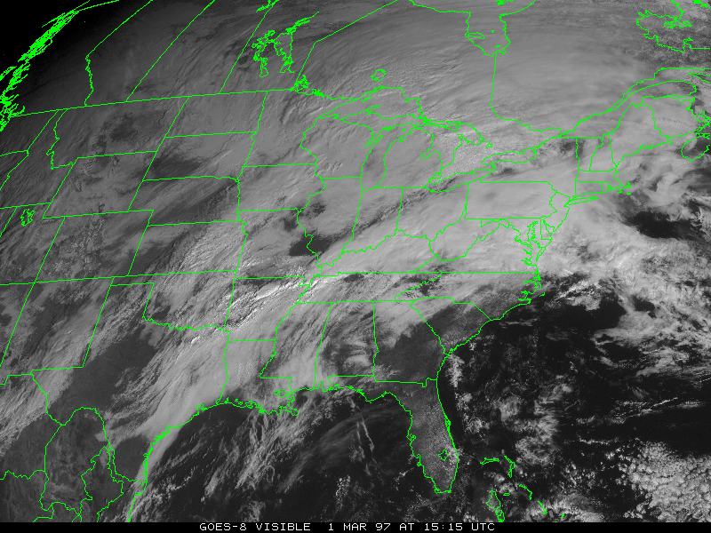 Regional Visible March 1 1515Z March 1 2115Z March 2 1515Z (350KB) |
 IR MPEG Heavy Rainfall (754KB) |
 Water Vapor MPEG Heavy Rainfall (317KB) |
 Enhanced AVHRR River Flooding (264KB) |
 NEXRAD Storm Total Estimated Rainfall (120KB) |
 NEXRAD Arkansas Base Reflectivity (100KB) |
 NEXRAD Arkansas Radial Velocity (100KB) |
| Rainfall Amounts | |
 Contoured |
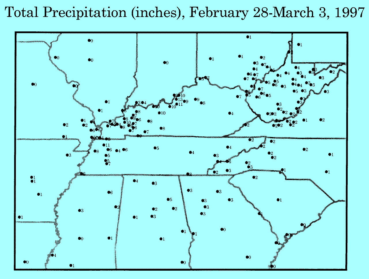 Plotted |
 Precipitation Table, Feb 28 - Mar 03
Total Precipitation (inches), February 28-March 3, 1997

                          Lat.  Lon.
St Station                dg mn dg mn  Prec.

AL Alabaster              33 15 86 49  3.49
AL Anniston               33 35 85 51  1.67
AL Auburn                 32 37 85 26  1.26
AL Birmingham             33 34 86 45  2.18
AL Dothan                 31 19 85 27 TRACE
AL Gadsden                33 58 86  5  4.72
AL Huntsville/Decatur     34 39 86 46  2.83
AL Montgomery             32 18 86 24  0.55
AL Muscle Shoals          34 45 87 37  3.55
AL Pinson                 33 41 86 42  2.57
AL Tuscaloosa             33 13 87 37  1.00
AR El Dorado              33 13 92 48  1.33
AR Jonesboro              35 50 90 39  3.12
AR Little Rock            34 44 92 14  1.13
AR North Little Rock      34 50 92 15  1.35
AR Pine Bluff             34 11 91 56  0.91
GA Alma                   31 32 82 30  0.00
GA Athens                 33 57 83 19  2.68
GA Atlanta                33 39 84 25  2.99
GA Augusta                33 22 81 58  0.57
GA Brunswick              31  9 81 23  0.00
GA Columbus               32 31 84 56  0.73
GA Gainesville            34 18 83 51  3.15
GA Macon                  32 42 83 39  0.01
GA Marietta               33 55 84 31  2.53
GA Peachtree City         33 22 84 34  3.24
GA Rome                   34 21 85 10  3.02
GA Savannah               32  8 81 12 TRACE
IL Brookport              37  8 88 38  5.27
IL Carbondale             37 43 89 13  1.34
IL Metropolis             37  9 88 43  7.25
IL Peoria                 40 40 89 41  0.26
IL Quincy                 39 57 91 12  0.24
IL Shawneetown            37 43 88 10  4.87
IL Springfield            39 51 89 40  0.32
IL Whittington            38  5 88 54  1.46
IN Boonville              38  3 87 16  3.68
IN Evansville             38  3 87 32  3.40
IN Fort Wayne             41  0 85 12  0.02
IN Indianapolis           39 44 86 16  0.41
IN New Albany             38 18 85 50  9.07
KY Barkley Lake           37  1 88 13  7.96
KY Bowling Green          36 58 86 25  8.28
KY Cadiz                  36 52 87 49  7.41
KY Cannelton Lock         37 53 86 46 10.40
KY Cobb                   36 59 87 46  6.03
KY Covington              39  3 84 40  2.65
KY Dawson Springs         37 10 87 41  6.65
KY Dixon                  37 31 87 41  6.75
KY Elk Creek              38  6 85 22  8.86
KY Elkton                 36 49 87  9  7.40
KY Fort Campbell          36 39 87 28  8.61
KY Fort Knox              37 53 85 58  9.90
KY Frankfort              38 11 84 52  9.28
KY Fredonia               37 13 88  4  9.53
KY Fulton                 36 31 88 53  3.37
KY Grayson 2E             38 20 82 54  5.94
KY Grayson 3SW            38 18 82 58  6.56
KY Hickman                36 34 89 11  3.65
KY Jackson                37 36 83 19  3.97
KY Kentucky Lake          37  1 88 16  6.35
KY Lexington              38  2 84 36  8.26
KY Louisville             38 11 85 44 13.04
KY Madisonville           37 20 87 30  6.20
KY Marion                 37 20 88  5  8.17
KY Paducah                37  4 88 46  6.76
KY Paradise               37 16 86 59  8.39
KY Princeton              37  6 87 53  9.35
KY Prospect               38 21 85 37  9.53
KY Providence             37 24 87 45  9.23
KY Rough River Lake       37 37 86 30  9.70
KY Sebree                 37 36 87 32  7.54
KY Shepherdsville         37 59 85 43 10.53
KY Smithland              37  8 88 24  4.36
LA Alexandria             31 20 92 33  0.44
MO Advance                37  6 89 55  2.11
MO Cape Girardeau         37 14 89 34  3.54
MO Charleston             36 55 89 20  5.66
MO Clearwater Dam         37  7 90 47  2.20
MO Columbia               38 49 92 13  0.30
MO Doniphan               36 37 90 49  1.40
MO Marble Hill            37 18 89 59  1.38
MO New Madrid             36 35 89 33  4.53
MO Sikeston               36 53 89 35  6.10
MO St. Louis              38 45 90 22  0.20
MS Columbus AFB           33 39 88 27  2.41
MS Greenwood              33 30 90  5  3.24
MS Jackson                32 19 90  5  0.49
MS McComb                 31 11 90 28  0.54
MS Meridian               32 20 88 45  1.28
MS Natchez                31 37 91 18  3.92
MS Tupelo                 34 16 88 46  5.51
NC Asheville              35 26 82 33  2.37
NC Beech Mountain         36 13 81 53  1.87
NC Charlotte              35 13 80 56  1.46
NC Fayetteville           35  8 78 56  0.66
NC Franklin               35 11 83 25  2.73
NC Grandfather Mtn.       36  6 81 49  0.46
NC Greensboro             36  5 79 57  1.81
NC Hendersonville         35 20 82 27  2.61
NC Hickory                35 44 81 23  2.00
NC Lenoir                 35 55 81 32  1.55
NC Murphy                 35  7 84  0  2.48
NC Raleigh/Durham         35 52 78 47  0.56
NC West Jefferson         36 25 81 26  1.75
OH Akron                  40 55 81 26  0.46
OH Beverly                39 33 81 38  3.77
OH Carpenter              39  8 82 12  6.58
OH Cincinnati-Lunken      39  6 84 25  2.16
OH Columbus               40  0 82 53  1.26
OH Dayton                 39 54 84 12  1.20
OH Jackson                39  3 82 38  6.67
OH Mansfield              40 49 82 31  0.55
OH Marietta               39 25 81 27  4.84
OH McArthur               39 15 82 29  5.55
OH McConnelsville         39 39 81 51  6.83
OH Nelsonville            39 28 82 14  4.48
OH New Lexington          39 43 82 12  2.50
OH Patriot                38 44 82 20  8.20
OH Salem Center           39  3 82 16  6.21
OH South Point            38 25 82 34  6.44
OH Zanesville             39 57 81 54  1.78
PA Pittsburgh             40 30 80 13  0.60
SC Beaufort               32 29 80 43 TRACE
SC Charleston-Airport     32 54 80  2  0.02
SC Charleston-City        32 47 79 56  0.01
SC Columbia               33 57 81  7  0.81
SC Greer                  34 54 82 13  2.29
TN Bradford               36  4 88 49  6.31
TN Bristol                36 29 82 24  2.46
TN Cades Cove             35 34 83 51  3.51
TN Camden                 36  4 88  6  6.05
TN Chattanooga            35  2 85 12  2.45
TN Crossville             35 57 85  5  4.04
TN Dyersburg              36  0 89 24  7.51
TN Humboldt               35 49 88 54  5.25
TN Huntington             36  1 88 25  3.57
TN Jackson                35 36 88 55  5.30
TN Knoxville              35 49 83 59  2.71
TN Medon                  35 28 88 52  6.79
TN Memphis                35  3 90  0  5.50
TN Morristown             36 10 83 24  3.71
TN Mt. Leconte            35 39 83 26  4.92
TN Nashville              36  8 86 41  4.51
TN Newfound Gap           35 34 83 25  5.80
TN Rutherford             36  8 89  0 10.52
TN Sugarland Center       35 41 83 32  3.13
VA Blacksburg             37 14 80 26  1.54
VA Bland                  37  6 81  6  1.70
VA Burkes Garden          37  5 81 20  2.02
VA Earle Hurst            37 40 80 14  1.80
VA Lynchburg              37 20 79 12  1.73
VA Pulaski                37  7 82 36  1.97
VA Radford                37  7 80 34  1.83
VA Roanoke                37 19 79 58  1.40
VA Staffordsville         37 16 80 43  1.88
WV Alexander              38 47 80 13  4.15
WV Bartow                 38 31 79 46  2.79
WV Beckley                37 47 81  7  1.94
WV Bemis                  38 49 79 44  2.70
WV Bluefield              37 18 81 12  1.69
WV Bluestone Dam          37 39 80 53  2.32
WV Buckeye                38 10 80  8  2.63
WV Buffalo                38 37 81 59  6.83
WV Cairo                  39 12 81  9  4.32
WV Charleston             38 21 81 38  4.89
WV Clarksburg             39 18 80 14  3.41
WV Creston                38 57 81 17  5.12
WV Cross Lanes            38 26 81 46  5.92
WV Elkins                 38 53 79 51  3.47
WV Fellowsville           39 20 79 50  3.33
WV Glady                  38 48 79 43  3.48
WV Hamlin                 38 17 82  6  5.56
WV Huntington             38 22 82 33  5.19
WV Mannington             39 32 80 20  4.00
WV Marlinton              38 13 80  5  2.66
WV Mullens                37 35 81 23  1.75
WV Oak Hill               37 59 81  9  2.73
WV Parkersburg            39 21 81 26  4.49
WV Parsons                39  6 79 14  2.87
WV Philippi               39  9 80  3  3.98
WV Pineville              37 35 81 32  1.71
WV Rock Cave              38 50 80 20  4.18
WV Romney                 39 21 78 45  2.47
WV Rosedale               38 44 80 57  2.98
WV Sandyville             38 54 81 40  4.77
WV Spencer                38 48 81 21  6.23
WV Terra Alta             39 27 79 33  3.08
WV Union                  37 35 80 33  1.50
WV Valley Head            38 33 80  2  3.07
WV Webster Springs        38 32 80 25  4.70
WV West Union             39 18 80 47  3.79
WV Weston                 39  2 80 28  4.38
WV Wheeling               40 11 80 39  2.15
WV White Sulphur Springs  37 48 80 18  2.32
WV Williamson             39 24 81 27  2.82
Additional Resources and Links
- Weather Events of 1993-1997
A Collection of Photographs from Ohio
USA Today News and Information
Cincinnati Enquirer News Stories
Spring Flood Potential Information
NWS Spring Snowmelt/Flooding Outlook
NWS Significant Events of '97 (Detailed Maps)
FEMA List of State Emergency Management Agencies/Links
FEMA Reports and Information
Top of Page
http://www.ncdc.noaa.gov/oa/reports/marchflooding/marchflooding.html
Downloaded Saturday, 20-Sep-2008 13:28:48 EDT
Last Updated Thursday, 01-Jul-2004 13:43:29 EDT by Neal.Lott@noaa.gov, Doug.Ross@noaa.gov
Please see the NCDC Contact Page if you have questions or comments.