 |
|||||||||
skip to content |
|||||||||
The Future of Weather Radar
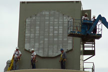
Workers install the radiating face of the phased array antenna during construction of the NWRT. The beam is shaped and steered by controlling the phase and off-on timing of the electromagnetic field generated by each radiator relative to the phases and pulses of other radiators in the array.
Radar is one of the most valuable tools in a forecaster’s arsenal and NSSL continues to use ingenuity and creativity to push radar technology to the edge. Right now, NSSL researchers are exploring phased array radar technology once used on Navy ships. Results already show this technology can detect rapidly evolving weather phenomena such as tornadoes and microbursts, potentially extending warning lead times for severe weather.
Phased array radars send out thousands of beams from a stationary antenna – a volume scan can take less than 30 seconds, compared with a minimum of 4 minutes with the NWS WSR-88D radars. NSSL researchers work with the phased array research radar, known as the National Weather Radar Testbed, located in Norman, Oklahoma. They have found the NWRT data collection capabilities provide improved resolution, accuracy and content of radar returns – all leading to improved detection of weather phenomena.
Using the NWRT, NSSL scientists are also exploring using phased array radar for aircraft tracking and wind profiling simultaneously with weather surveillance. This concept of a multi-function phased array radar has great potential to meet the Nation’s weather, aviation, and homeland security needs.
NSSL hosted national symposium on MPAR
“Leveraging Technology for a Next-Generation National Radar System” was the theme for a pivotal symposium, sponsored by the Office of the Federal Coordinator for Meteorology and hosted by NSSL last fall. The MPAR symposium aimed to advance the state of MPAR research and development and to further document the needs of the radar user community, The symposium also highlighted the social and economic benefits from MPAR risk reduction research.
Research with PAR
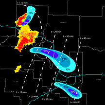
MPAR may enable average lead times to be extended to 45 minutes by issuing warnings based on forecasts from earlier precursor conditions. (larger image)
Phased-array radar provides early detection of hazards
NOAA’s NSSL
researchers have confirmed PAR can detect rotation, hail, microbursts
and gust fronts well ahead of other radars due to its rapid volume scan
capability. During the summer of 2006 the NWRT (research PAR), WSR-88D,
and Terminal Doppler Weather Radar (TDWR) scanned four thunderstorm cases
in central Oklahoma. NSSL researchers compared the data and found the
NWRT detected severe weather hazards several minutes in advance of the
other radars. Earlier detection of hazardous severe weather using PAR
has strong potential to aid forecasters in the forecast and warning decision
process, helping to protect the aviation community and the public.
Phased array radar data used by forecasters in
simulated warning environment
Real-time phased array radar (PAR) data from the NOAA NWRT was introduced
to a small number of operational forecasters from National Weather Service
Forecast Offices across the U.S. for the first time during Spring, 2008.
During the real-time simulation, the forecasters performed their usual
warning decision-making duties while the lead/researcher team ran the
PAR data collection. Following each operation period, the team evaluated
the operational benefits and challenges of rapid update PAR data.
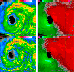
Comparison of radar reflectivity (left) and velocity (right) data between PAR (top) and KTLX (bottom) from Tropical Storm Erin in May 2007. (larger image)
PAR: Applications to landfalling tropical cyclones
The NWRT in Norman, Oklahoma had a fortuitous opportunity in August,
2007 to gather data from its research phased array radar on Tropical
Storm Erin, which came ashore on the Gulf Coast of Texas, tracked north,
and regained strength in central Oklahoma, well within range of the
NWRT. Comparison of data from the NWRT and the collocated Norman WSR-88D
reveals the power of PAR’s rapid scanning in discerning features
of interest in Erin’s convective bands, in particular the rapid
spin-off of tornadoes. Because the NWRT was able to revisit areas of
interest much more rapidly than was the WSR-88D, earlier detection
of severe weather signatures was possible.
Weather radar originated from military technology. Similarly, the U.S. Navy offers its SPY-1 radar, a phased array radar, as another step in refining technology to warn the public of hazardous weather and help protect their lives and property.
Related links:
History
of Weather Radar
Multifunction Phased Array Radar video overview
The National Severe Storms Laboratory in Norman, Oklahoma conducts research to improve accurate and timely forecasts and warnings of hazardous weather events such as blizzards, ice storms, flash floods, tornadoes, and lightning. NSSL, one of NOAA's research laboratories, accomplishes this goal through a balanced program of research to advance the understanding of weather processes, research to improve forecasting and warning techniques, development of operational applications, and transfer of understanding, techniques, and applications to the National Weather Service and other agencies. |
6/16/08
CLIMATE · OCEANS, GREAT LAKES, and COASTS · WEATHER
and AIR QUALITY
ABOUT US · RESEARCH
PROGRAMS · EDUCATION · HOME