
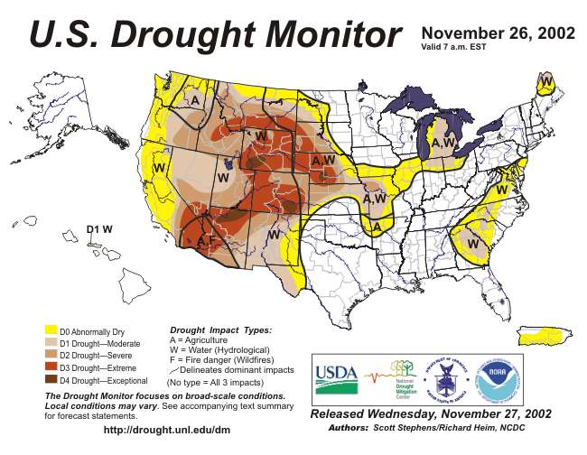
| Severe to exceptional drought continued throughout much of the western United States. Two months of above average precipitation in the eastern U.S. brought significant relief to long-term drought conditions. |

larger image
|

larger image
|
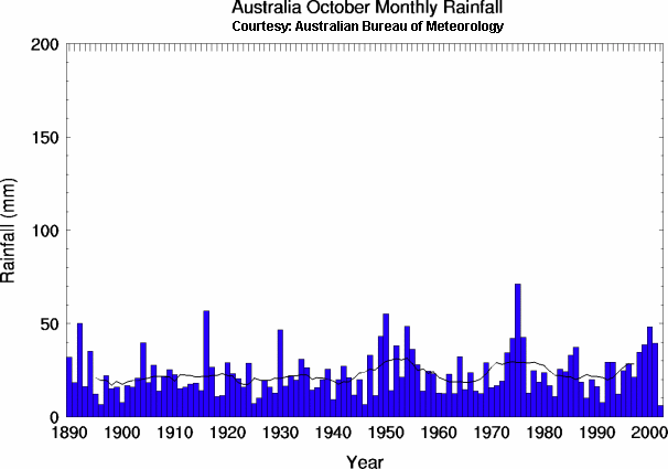
Unseasonably warm and dry weather continued during September-November across much of Australia, with much of New South Wales recording the driest October on record. Temperatures during November were 2-4°C (3.6-7.2°F) above normal across New South Wales, which exacerbated existing dryness. Although some rainfall was received in the far north and east part of the country during November, much of the nation still escaped enough moisture to ease long-term drought conditions.
|
| Drought in Australia was expected to reduce the economic growth by one percentage point this year, mainly through declining agricultural output (BBC News). Nationally, Australia recorded the driest October 2002 on record. |

larger image
|
Dry, hot weather exacerbated the threat for wildfires across eastern Australia. By the 25th, at least 55 separate wildfires burned in New South Wales, with 1,500 firefighters battling blazes which had charred over 470,000 hectares (1.2 million acres) (Reuters).
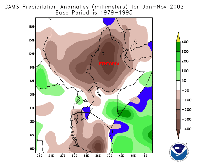
| Across Africa, Ethiopian government officials reported that nearly 6 million people are threatened by drought (AFP), with nearly 1.4 million under immediate risk of starvation (Reuters). In Zambia, drought that has destroyed grazing pastures threatened the country's rare white rhino population (Reuters). Six consecutive poor harvests due to a lack of rainfall in Mauritania has adversely impacted farmers and decimated livestock herds (BBC News). |

larger image
|


 larger image
|
In North Africa, a strong cold front trekked across Morocco during November 17-18 and produced severe flooding which resulted in at least 60 deaths (ENS). Flood damage also ignited a fire at a large oil refinery in the industrial town of Mohammedia. The flash flooding was characterized as the worst to strike the country in 30 years (IFRC).
|
| Stormy weather extended northward across southern Europe, where flooding and mudslides were reported through much of northern Italy and the Swiss Alps. Wet weather throughout much of November caused numerous rivers and streams to rise above flood stage, flooding thousands of homes and businesses (ITV News). |

larger image
|
| In southeast Asia, flooding that began in September with the onset of the monsoon season continued into early November across parts of Vietnam, Thailand and Cambodia. |

larger image
|
Heavy rains during November 19-24th across northern Sumatra in Indonesia caused severe flooding in the province of Nanggroe Aceh Darussalam, killing at least 26 people and inundating around 2,000 houses.
 larger image
|
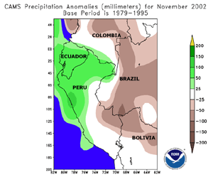
In Peru, flooding along the Blanco River in the Amazon jungle region killed 4 people on the 10th. The river brought flooding to four towns near the city of Satipo, about 280 km (175 miles) east of Lima (Associated Press).
|
For a description of other flood events worldwide, see the Dartmouth Flood Observatory.

| A major outbreak of severe weather and tornadoes occurred across the U.S. Tennessee and Ohio valley region on November 10-11, 2002, producing damage in 13 states. A total of 75 tornadoes touched down on Sunday 10th, resulting in at least 36 deaths (ENS).
|

larger image
|
Radar Animation
Courtesy of UCAR
|
Severe thunderstorms moved across southeastern Alabama and the Florida panhandle on November 5th, producing wind damage and several tornadoes. A tornado struck the Alabama town of Abbeville killing 2 people and injuring 25 (Associated Press). Alabama governor Don Siegelman declared the town a disaster area, as the local high school was damaged along with several homes.
|

| Tropical Cyclone Atang developed in the southern Indian Ocean on the 6th and moved slowly westward, making landfall near the Mozambique/Tanzania border on the 12th. Maximum sustained winds at the time of landfall were near 65 km/hr (35 knots or 40 mph), accompanied by locally heavy rainfall. |

larger image
|

larger image
|
Hurricane Huko developed in the open waters of the eastern Pacific Ocean, well south of the Hawaiian Islands, on October 24. Huko strengthened into a hurricane by the 28th as it tracked slowly westward. Huko passed west of the dateline on the 3rd and was subsequently renamed a typhoon. Huko passed near Wake Island on November 5th, producing heavy rains and wind gusts over 75 km/hr (40 knots or 45 mph). Huko weakened and lost its tropical characteristics by the 7th as it accelerated to the northeast.
|
A strong cyclone (the remnants of tropical cyclone 03B) which impacted the coast of India and Bangladesh on November 17th has led to the deaths of at least 49 Indian and Bangladeshi fishermen. One hundred and eleven fishermen were still missing as of the 15th (BBC).
For the latest official advisories and information on tropical systems in the western Pacific, please refer to the Joint Typhoon Warning Center. In the central Pacific, the latest information can be obtained from the Central Pacific Hurricane Forecast Center, while the latest advisories on Atlantic and eastern Pacific systems are available from the National Hurricane Center.
A preliminary summary of 2002 tropical storms and hurricanes in the Atlantic Basin is available.

| In the southwestern United States, strong Santa Ana winds affected much of southern California during November 20-26th. Winds on the 26th gusted to over 95 km/hr (50 knots or 60 mph), producing over 75,000 power outages to customers. Several small wildfires were also reported in the mountains east of Los Angeles and across the Sierra Nevada mountains. |

larger image
|
 Powerful Storm System Affects Western U.S.
Click for Loop (3.2MB)
|
The first significant storm system of the season for the western United States affected much of Washington, Oregon and California during November 7-8.
Rainfall amounts exceeded 50 mm (2 inches) across many coastal areas, with more than a foot of snow (30 cm) reported across higher elevations. Strong winds gusting to over 75 km/hr (40 knots or 45 mph) were reported along the Oregon coast, with wind gusts near 110 km/hr (60 knots or 70 mph) observed in the San Francisco Bay area, which caused over 300,000 power outages. A meteorological buoy located several hundred miles offshore reported wave heights of over 12 meters (40 feet).
|

larger image
|
The eastern Pacific storm system was responsible for the issuance of numerous weather advisories and warnings across the western United States on the 7th, as heavy precipitation and strong winds affected a wide area.
|
A strong storm occurred in Spain and Portugal during November 13th. The storm led to several deaths as construction cranes toppled over in the high winds in 2 separate incidents on mainland Spain. The storm and high seas also contributed to the sinking of an oil tanker off the Spanish coast, resulting in an extensive oil spill. Winds gusted to around 130 km/hr (70 knots or 80 mph) in Portugal and trees and power lines were torn down by the high winds in both nations.
For current weather advisories in the western U.S., please refer to the National Weather Service.


larger image
|
Unusually cold temperatures prevailed across northern Scandinavia during late November. Low temperatures at Nikkaluokta in northern Sweden dipped to -30°C (-22°F) on the 23rd which is over 17°C (30°F) below normal for this time of year.
|
| November began with unusually cold temperatures across much of the United States, with daily average temperatures over 5°C (9°F) below normal in many areas. In contrast, temperatures across Alaska were over 10°C (18°F) warmer than normal across some sections of the interior. |

Click for Animation
|
References:
Basist, A., N.C. Grody, T.C. Peterson and C.N. Williams, 1998: Using the Special Sensor Microwave/Imager to Monitor Land Surface Temperatures, Wetness, and Snow Cover. Journal of Applied Meteorology, 37, 888-911.
Peterson, Thomas C. and Russell S. Vose, 1997: An overview of the Global Historical Climatology Network temperature data base. Bulletin of the American Meteorological Society, 78, 2837-2849.
For all climate questions other than questions concerning this report, please contact the National Climatic Data Center's Climate Services Division:
Climate Services Division
NOAA/National Climatic Data Center
151 Patton Avenue, Room 120
Asheville, NC 28801-5001
fax: 828-271-4876
phone: 828-271-4800
email: ncdc.orders@noaa.gov
For more information, refer also to ...
October 2002 Hazards
and Significant Events
Selected U.S. City and State Extremes
2002 Atlantic Hurricanes
2002 U.S. Wildfire Summary
SSMI Derived Products
Global Historical Climatology Network (GHCN)
The Global Temperature Anomalies
CLIMVIS - Global Summary of the Day
CAMS data provided by the Climate Prediction Center
Geographic Reference Maps (pdf format)
For further information on the historical climate perspective presented in this report, contact:
Scott Stephens
NOAA/National Climatic Data Center
151 Patton Avenue
Asheville, NC 28801-5001
fax: 828-271-4328
email: Scott.Stephens@noaa.gov
-or-
Jay Lawrimore
NOAA/National Climatic Data Center
151 Patton Avenue
Asheville, NC 28801-5001
fax: 828-271-4328
email: Jay.Lawrimore@noaa.gov

 NCDC / Climate
Monitoring / Climate
of 2002 / Hazards / Search / Help NCDC / Climate
Monitoring / Climate
of 2002 / Hazards / Search / Help
http://www.ncdc.noaa.gov/oa/climate/research/2002/nov/hazards.html
Downloaded Saturday, 20-Sep-2008 12:25:54 EDT
Last Updated Friday, 17-Nov-2006 10:59:43 EST by Scott.Stephens@noaa.gov
Please see the NCDC Contact Page if you have questions or comments.
|


