
 Feeds & Data
Magnitude 5.4 - CERAM SEA, INDONESIA
2008 September 16 01:12:53 UTC
Earthquake Details
| Magnitude | 5.4 |
|---|---|
| Date-Time |
|
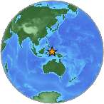
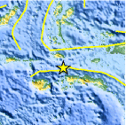
| Location | 2.358°S, 128.033°E |
| Depth | 43 km (26.7 miles) |
| Region | CERAM SEA, INDONESIA |
| Distances | 145 km (90 miles) N of Ambon, Moluccas, Indonesia 355 km (220 miles) SSE of Ternate, Moluccas, Indonesia 1155 km (720 miles) NNW of DARWIN, Northern Territory, Australia 2400 km (1490 miles) E of JAKARTA, Java, Indonesia |
| Location Uncertainty | horizontal +/- 15.4 km (9.6 miles); depth +/- 28.9 km (18.0 miles) |
| Parameters | NST= 22, Nph= 22, Dmin=965.1 km, Rmss=1.12 sec, Gp= 76°, M-type=body magnitude (Mb), Version=6 |
| Source |
|
| Event ID | us2008xaaf |
- This event has been reviewed by a seismologist.
- Did you feel it? Report shaking and damage at your location. You can also view a map displaying accumulated data from your report and others.
Earthquake Summary
Earthquake Information for Asia
Earthquake Information for Indonesia
 Tsunami Information
- NOAA West Coast & Alaska Tsunami Warning Center
- NOAA Pacific Tsunami Warning Center
- Tsunami Information Links
The earthquake locations and magnitudes cited in these NOAA tsunami bulletins are very preliminary and may be superceded by USGS locations and magnitudes computed using more extensive data sets.
Earthquake Maps
Earthquake Location
Location Maps
Historical Seismicity
Seismic Hazard Map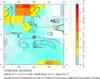
EQ Density Map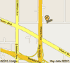
Google Map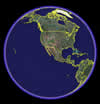
Google Earth KML
(Requires Google Earth)- Did you feel it? Report shaking and damage at your location. You can also view a map displaying accumulated data from your report and others.
Scientific & Technical Information
 Historic Moment Tensor Solutions
- Preliminary Earthquake Report
- U.S. Geological Survey, National Earthquake Information Center:
World Data Center for Seismology, Denver
