
 Feeds & Data
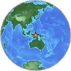
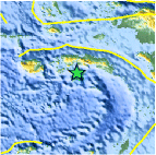
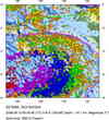
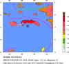
Magnitude 5.6 - SERAM, INDONESIA
2008 September 13 00:04:04 UTC
Earthquake Details
| Magnitude | 5.6 |
|---|---|
| Date-Time |
|
| Location | 3.773°S, 128.945°E |
| Depth | 100.9 km (62.7 miles) |
| Region | SERAM, INDONESIA |
| Distances | 85 km (55 miles) E of Ambon, Moluccas, Indonesia 415 km (260 miles) SW of Sorong, Papua, Indonesia 990 km (610 miles) NNW of DARWIN, Northern Territory, Australia 2475 km (1540 miles) E of JAKARTA, Java, Indonesia |
| Location Uncertainty | horizontal +/- 5.3 km (3.3 miles); depth +/- 11.5 km (7.1 miles) |
| Parameters | NST=129, Nph=129, Dmin=>999 km, Rmss=0.76 sec, Gp= 47°, M-type=regional moment magnitude (Mw), Version=8 |
| Source |
|
| Event ID | us2008wxac |
- This event has been reviewed by a seismologist.
- Did you feel it? Report shaking and damage at your location. You can also view a map displaying accumulated data from your report and others.
Earthquake Summary
Earthquake Information for Asia
Earthquake Information for Indonesia
 Tsunami Information
- NOAA West Coast & Alaska Tsunami Warning Center
- NOAA Pacific Tsunami Warning Center
- Tsunami Information Links
The earthquake locations and magnitudes cited in these NOAA tsunami bulletins are very preliminary and may be superceded by USGS locations and magnitudes computed using more extensive data sets.
Earthquake Maps


Scientific & Technical Information

- Preliminary Earthquake Report
- U.S. Geological Survey, National Earthquake Information Center:
World Data Center for Seismology, Denver
