
 Feeds & Data
Magnitude 6.6 - CENTRAL MID-ATLANTIC RIDGE
2008 September 10 13:08:14 UTC
Earthquake Details
| Magnitude | 6.6 |
|---|---|
| Date-Time |
|
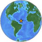
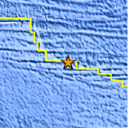
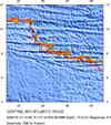
| Location | 8.091°N, 38.748°W |
| Depth | 10 km (6.2 miles) set by location program |
| Region | CENTRAL MID-ATLANTIC RIDGE |
| Distances | 1260 km (780 miles) NNE of Parnaiba, Piaui, Brazil 1320 km (820 miles) NNE of Sao Luis, Maranhao, Brazil 1515 km (940 miles) NE of Belem, Para, Brazil 2820 km (1750 miles) NNE of BRASILIA, Distrito Federal, Brazil |
| Location Uncertainty | horizontal +/- 4.8 km (3.0 miles); depth fixed by location program |
| Parameters | NST=304, Nph=304, Dmin=>999 km, Rmss=0.86 sec, Gp= 22°, M-type=regional moment magnitude (Mw), Version=R |
| Source |
|
| Event ID | us2008wubm |
- This event has been reviewed by a seismologist.
- Did you feel it? Report shaking and damage at your location. You can also view a map displaying accumulated data from your report and others.
Earthquake Maps


Scientific & Technical Information

Additional Information, News Reports
- Preliminary Earthquake Report
- U.S. Geological Survey, National Earthquake Information Center:
World Data Center for Seismology, Denver
