
 Feeds & Data
Magnitude 2.5 - ISLAND OF HAWAII, HAWAII
2008 September 15 17:09:20 UTC
Earthquake Details
| Magnitude | 2.5 |
|---|---|
| Date-Time |
|
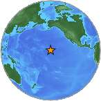
| Location | 19.408°N, 155.275°W |
| Depth | 0.2 km (~0.1 mile) (poorly constrained) |
| Region | ISLAND OF HAWAII, HAWAII |
| Distances |
|
| Location Uncertainty | horizontal +/- 0.2 km (0.1 miles); depth +/- 0.6 km (0.4 miles) |
| Parameters | Nph=011, Dmin=1 km, Rmss=0.15 sec, Gp= 83°, M-type=duration magnitude (Md), Version=0 |
| Source | |
| Event ID | hv00030402 |
- This is a computer-generated message -- this event has not yet been reviewed by a seismologist.
- Did you feel it? Report shaking and damage at your location. You can also view a map displaying accumulated data from your report and others.
Earthquake Maps
Earthquake Location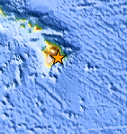
Location Maps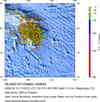
Historical Seismicity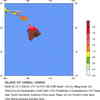
Seismic Hazard Map
Google Map
Google Earth KML
(Requires Google Earth)- Did you feel it? Report shaking and damage at your location. You can also view a map displaying accumulated data from your report and others.
Scientific & Technical Information
 Historic Moment Tensor Solutions
- Preliminary Earthquake Report
- U.S. Geological Survey, Hawaiian Volcano Observatory
Hawaii National Park, Hawaii
