
 Feeds & Data
Magnitude 3.0 - SOUTHERN CALIFORNIA
2008 September 10 12:46:30 UTC
Earthquake Details
| Magnitude | 3.0 |
|---|---|
| Date-Time |
|
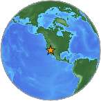
| Location | 33.681°N, 116.795°W |
| Depth | 18.7 km (11.6 miles) |
| Region | SOUTHERN CALIFORNIA |
| Distances |
|
| Location Uncertainty | horizontal +/- 0.2 km (0.1 miles); depth +/- 0.4 km (0.2 miles) |
| Parameters | Nph=122, Dmin=7 km, Rmss=0.27 sec, Gp= 29°, M-type=local magnitude (ML), Version=Q |
| Source | |
| Event ID | ci10348029 |
- This event has been reviewed by a seismologist.
- Did you feel it? Report shaking and damage at your location. You can also view a map displaying accumulated data from your report and others.
Earthquake Maps
Earthquake Location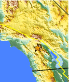
Location Maps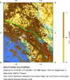
Historical Seismicity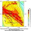
Seismic Hazard Map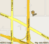
Google Map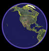
Google Earth KML
(Requires Google Earth)- Did you feel it? Report shaking and damage at your location. You can also view a map displaying accumulated data from your report and others.
 Historic Moment Tensor Solutions