 |
 |
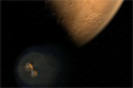
Seeing Mars Better Than Ever
- October 17, 2006
NASA's newest Mars spacecraft, the Mars Reconnaissance Orbiter, is providing an unprecedented view of the surface of Mars.
|
|
 |
An Opportunity to Study Mars
- October 06, 2006
This video compilation shows images from the Mars Exploration Rover Opportunity's 32 months on Mars.
|
|
 |
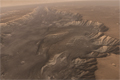
Animated Elevation Model of 'Victoria Crater'
- September 11, 2006
After driving more than 9 kilometers (5.6 miles) from the site where it landed in January 2004, NASA's Mars Exploration Rover Opportunity approached "Victoria Crater" in September 2006. The crater is about 750 meters (half a mile) across. That is about six times wider than "Endurance Crater," which Opportunity spent six months examining in 2004, and about 35 times wider than "Eagle Crater," where Opportunity first landed. The walls of Victoria hold the scientific allure of much taller stacks of geological layers -- providing the record of a longer span of the area's environmental history -- than Opportunity has been able to inspect on the Meridiani plains or at smaller craters.
This animation created by the U.S. Geological Survey uses a digital elevation model generated from computer analysis of three images taken by the Mars Orbiter Camera aboard NASA's Mars Global Surveyor orbiter. The vertical dimension is not exaggerated relative to the horizonal dimensions. The crater is about 70 meters (230 feet) deep.
The images used for providing the stereo information to calculate relative elevation were taken on Feb. 1, 2004,
Feb. 15, 2004 and April 16, 2005. The animation begins and ends with the view looking from the northwest toward the southeast. Opportunity is approaching Victoria from the northwest.
Image credit: NASA/JPL/MSSS/USGS
|
|

|
30 Years: Memories from Mars Viking
- September 03, 2006
Viking retirees and prior team members share adventures about their involvement with the first mission to land on another planet.
|
|
 |
Rover Road Trip Slideshow
The Mars Rovers Spirit and Opportunity have seen quite a bit during their second Martian year.
|
|
 |
Mars Viking Trailblazer
- June 22, 2006
Thirty years ago, the Viking mission arrived at Mars, giving us the first view from the surface of the red planet.
|
|
 |
Mars Reconnaissance Orbiter Context Imager Instrument Pointing Simulation
- May 01, 2006
This animation highlights the orbiter's context imager as it took and returned its first image.
|
|
 |
Mars Reconnaissance Orbiter First Images of Mars from HiRISE
- May 01, 2006
This animation highlights the first images returned by the orbiter's HiRISE (High Resolution Imaging Science Experiement) camera.
|
|
 |
Mars Reconnaissance Orbiter Instrument Pointing Simulation
- May 01, 2006
In order to wow us with amazing new views of the Red Planet, Mars Reconnaissance Orbiter must be able to rotate its instrument deck to face its target. This animation features the spacecraft moving to get into position for optimal martian snapshots!
|
|
 |
Mars Reconnaissance Orbiter Mars Color Imager Instrument Pointing Simulation
- May 01, 2006
This animation highlights the first use of the MARCI (Mars Color Imager) camera on Mars Reconnaissance Orbiter.
|
|
 |
The Challenges of Getting to Mars: Dip and Drag
- April 03, 2006
With the spacecraft safely captured into orbit, the Mars Reconnaissance Orbiter team transitions to the next critical phase -- aerobraking. Learn how engineers slow the spacecraft and precisely shape its orbit using the dynamic atmosphere of Mars.
|
|
 |
Flight Into Mariner Valley (Valles Marineris, Mars)
- March 13, 2006
This video created by JPL's Solar System Visualization Team uses real scientific data from Odyssey's Thermal Emission Imaging System's Infrared Camera to simulate a flight from a few hundred feet above the largest canyon in the solar system, Valles Marineris on Mars. The image data was draped over topography information from the Mars Orbiter Laser Altimeter on the Mars Global Surveyor orbiter. Every canyon wall and curve in the animation is rendered from real data from Mars except for the simulated atmosphere, dust devils, and dust storms.
Full Credits (PDF, 32 kB)
|
|

|
Mars Reconnaissance Orbiter Launch, Mars Orbit Insertion and Aerobraking Animation
- March 09, 2006
Follow the journey of NASA's next generation Mars orbiter during its launch, through the vastness of space and as it reaches critical mission milestones. The spacecraft's powerful suite of instruments and their unprecedented capabilities are highlighted.
|
|
 |
The Challenges of Getting to Mars: Burn and Capture
- March 07, 2006
After millions of miles, dozens of tests, a handful of calibrations and a number of "dress rehearsals," the Mars Reconnaissance Orbiter arrives at the red planet on March 10, 2006. Find out how engineers prepare the spacecraft and themselves for this complicated engine burn and capture into Mars' orbit.
|
|
 |
A Mars Eye Opener
- March 06, 2006
The Mars Reconnaissance Orbiter will see things at Mars in greater detail than ever before.
|
|
 |
Next Leap in Mars Exploration
- March 03, 2006
Mars Reconnaissance Orbiter will bring new capabilities to Mars exploration. The spacecraft arrives at Mars Mar. 10, 2006.
|
|
 |
The Challenges of Getting to Mars: Hitting the Bull's-Eye
- February 24, 2006
Hitting a moving target over 306 million miles away is no easy feat. Learn how JPL navigation engineers have guided the Mars Reconnaissance Orbiter toward its mission-critical capture into orbit around the red planet.
|
|
 |
Two Years on Mars (Flash)
- January 24, 2006
The Mars Exploration Rovers mark two years on the red planet.
|
|
 |
Special-Effects Spirit on Flank of "Husband Hill"
- January 23, 2006
This synthetic image of the Spirit Mars Exploration Rover on the flank of "Husband Hill" was produced using "Virtual Presence in Space" technology. Developed at NASA's Jet Propulsion Laboratory, Pasadena, Calif., this technology combines visualization and image-processing tools with Hollywood-style special effects. The image was created using a photorealistic model of the rover and a false-color mosaic. The size of the rover in the image is approximately correct and was based on the size of the rover tracks in the mosaic. The mosaic was assembled from frames taken by the panoramic camera on the rover's 454th Martian day, or sol (April 13, 2005); see PIA07855.
Because this synthesis provides viewers with a sense of their own "virtual presence" (as if they were there themselves), such views can be useful to mission teams in planning exploration by enhancing perspective and a sense of scale.
Image note: Rover model by Dan Maas; synthetic image by Koji Kuramura, Zareh Gorjian, Mike Stetson and Eric M. De Jong.
Image credit: NASA/JPL-Caltech/Cornell
|
|
 |
Erebus Rim - January 23, 2006
This is the Opportunity panoramic camera's "Erebus Rim" panorama, acquired on sols 652 to 663 (Nov. 23 to Dec. 5, 2005 ), as NASA's Mars Exploration Rover Opportunity was exploring sand dunes and outcrop rocks in Meridiani Planum. The panorama originally consisted of 635 separate images in 4 different Pancam filters, and covers 360 degrees of terrain around the rover and the full rover deck. Since the time that this panorama was acquired, and while engineers have been diagnosing and testing Opportunity's robotic arm, the panorama has been expanded to include more than 1,300 images of this terrain through all of the Pancam multispectral filters. It is the largest panorama acquired by either rover during the mission.
The panorama shown here is an approximate true-color rendering using Pancam's 750 nanometer, 530 nanometer and 430 nanometer filters. It is presented here as a cylindrical projection. Image-to-image seams have been eliminated from the sky portion of the mosaic to better simulate the vista a person standing on Mars would see.
This panorama provides the team's highest resolution view yet of the finely-layered outcrop rocks, wind ripples, and small cobbles and grains along the rim of the wide but shallow "Erebus" crater. Once the arm diagnostics and testing are completed, the team hopes to explore other layered outcrop rocks at Erebus and then eventually continue southward toward the large crater known as "Victoria."
|


