
The National Oceanic and Atmospheric Administration's National Severe Storms Laboratory leads the way in investigations of all aspects of severe and hazardous weather. Severe weather research conducted at NSSL has led to substantial improvements in severe and hazardous weather forecasting resulting in increased warning lead times to the public. NSSL scientists are exploring new ways to improve our understanding of the causes of severe weather and ways to use weather information to assist National Weather Service forecasters, as well as federal, university and private sector partners.
Historical Accomplishments
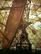
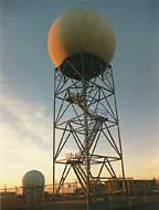
- NSSL recognized the potential of Doppler radar to improve the detection and warning of severe weather. NSSL built the first real-time displays of Doppler velocity data with data calculated using pulse-pair processing. This capability lead to discoveries of tornado-related signatures resulting in a joint field experiment called the Joint Doppler Operational Project. The successful demonstration that the Doppler radar could provide much improved severe thunderstorm and tornado warnings led to the Next Generation Weather Radar program (NEXRAD) that resulted in the WSR-88D operational network of Doppler radars for our Nation. This important contribution to our Nation was recognized by the Department of Commerce's presentation of its Gold Medal to NSSL.
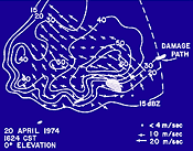
- NSSL made the first observations of a tornadic storm with dual Doppler radars on 20 April 1974. This allowed for the mapping of the kinematic structure of a tornadic storm at several altitudes. Pioneering studies using dual Doppler analysis also led to the capability of dynamic and microphysical retrievals that provided reasonably accurate estimates of the temperature, pressure and water quantities over three dimensional storm volumes at one time.
- NSSL continued to refine and build new conceptual models of severe storms, supercell structures and mesoscale convective complexes and systems. These conceptual models have led to improved forecasting and warnings of tornadoes, flash floods, damaging winds, and hail. In addition, these models have led to understanding of environments conducive to the formation of thunderstorms, mesocyclones and mesoscale convective complexes.
- NSSL continued to refine the use of airborne Doppler for the studies of both mesoscale and stormscale phenomena. Since the installation of Doppler radar on the NOAA P-3 in 1983 by the National Hurricane Research Laboratory (now part of AOML) and the National Center for Atmospheric Research, NSSL has continued to provide new insights into the structure of mesoscale systems. The laboratory obtained the first direct measurements of a tornado recorded with an airborne Doppler. New concepts of making dual Doppler measurements using the WSR-88D with the P-3 Doppler were first tested in 1989 and are now used routinely.
- NSSL developed the first automated algorithm for the detection of mesocyclones and provided the first automated wind profiles using the Velocity Azimuth Display (VAD) technique. Both these algorithms were an important part of the first suite of algorithms used on the operational WSR-88D radars.
- NSSL developed the first truly mobile capability for obtaining upper-air soundings of the atmosphere using the Cross-Chain Loran Atmospheric Sounding System mounted in 15-passenger vans modified to be mobile laboratories. NSSL pioneered techniques and invented a high-wind launch device for releasing helium filled balloons in very high winds. This capability allowed NSSL to take upper-air soundings in the vicinity of tornadoes and drylines, obtaining critically needed observations in the near-storm environment of thunderstorms. In addition, this capability provided the first vertical profiles of electric fields inside a thunderstorm leading to a new conceptual model of electrical structures within convective storms.
Recent Highlights
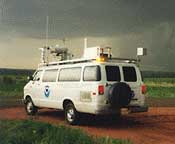
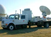
- NSSL collaborated with the University of Oklahoma, Texas Tech and Texas A&M University to build two new 5-cm mobile Doppler radars. These SMART-Radars (Shared Mobile Atmospheric Research and Teaching Radars) are capable of scanning and penetrating an entire tornadic storm or hurricane. In addition, mobile mesonets continue to be used to obtain important environmental data in the vicinity of supercells and tornadoes. Both these observing tools have provided new data for unwrapping the mysteries of how tornadoes are formed and for eventually improving severe storm warnings.
- NSSL is committed to incorporating cutting-edge scientific understanding of severe weather signatures into tools designed to help National Weather Service forecasters make better and faster warning decisions. The latest tool, NSSL's Warning Decision Support System II, includes automated algorithm detection tools for the NEXRAD Doppler radar and other sensors to identify rotation in storms preceding tornadoes, likelihood and size of hail, as well as simply identifying and tracking storms. This information is presented in an easy-to-use display including tables, graphs and data interrogation tools. Several of these tools have already been integrated into the National Weather Service's systems and have contributed to extended warning lead times with fewer false alarms. The WDSS-II platform has extended the life of the WSR-88D radar under the National Weather Service NEXRAD Product Improvement Program by allowing continuous improvement and development of algorithms by NSSL in support of NWS's mission.
- NSSL worked directly with the National Weather Service to complete a significant upgrade to the NEXRAD WSR-88D Doppler radar. The Open Radar Product Generator's (ORPG) software and hardware were redesigned using open systems concepts, providing a system that is now capable of growing and adapting to meet the ever increasing demands of its users. NSSL was responsible for the design and implementation of the system software architecture. The ORPG's redesign allows new science and technology to be transferred to NWS operations more quickly and dramatically lowers maintenance and future upgrade costs.
- Scientists from NSSL recently completed several field experiments to study severe and hazardous weather. In 2003 and 2004, researchers launched weather balloons loaded with instruments into thunderstorms during the Thunderstorm Electrification and Lightning Experiment, or TELEX. The lightning observations they made will be used to improve forecasts and warnings of hazardous weather. In 2002, NSSL hosted the International H2O Project or IHOP, one of the largest weather-related studies ever conducted in the U.S. Scientists searched for swaths of water vapor and wind convergence bands that can fuel heavy rain across the southern Great Plains. In 2000, IPEX, the Intermountain Precipitation Experiment, was conducted to improve forecasts of winter weather, especially in the high population growth areas of the western United States. Also in 2000, researchers participating in STEPS, the Severe Thunderstorm Electrification and Precipitation Study, focused a number of data gathering tools on thunderstorms in the high plains to better understand how rain and lightning are formed. The knowledge gained through these field programs will lead to better forecasts of deadly weather phenomena including tornadoes, lightning, hail, flash floods, heavy snow, ice and freezing rain.
Current Research Projects
- NSSL continues to be a pioneer in the development of weather radar. The lab is presently studying the use of dual polarization radar to improve precipitation measurements and hail identification. This planned upgrade to the current NEXRAD Doppler radar hardware provides more information about precipitation in clouds to better distinguish between rain, ice, hail and mixtures. Such information will help forecasters provide better warnings for flash floods, the number one severe weather threat to human life.
- NSSL researchers are adapting state-of-the-art radar technology currently deployed on Navy ships for use in tracking severe weather. Phased array radar reduces the scan or data collection time from five or six minutes to less than one minute, potentially extending the average lead time for tornado warnings beyond the current average of 12 minutes. When combined with other technology being developed at NSSL, warning lead times may be extended even farther.
- A new Lightning Mapping Array installed in Central Oklahoma provides researchers with the time and three-dimensional location for lightning segments. This information will help researchers investigate how lightning characteristics relate to updrafts, precipitation and severe storm processes, as well as assimilating lighting data into weather forecast models.
- One research group at NSSL is investigating the computation, analysis and display of high-resolution radar data and radar-derived products to achieve accurate rainfall and snowfall estimates. Quantitative Precipitation Estimation and Segregation Using Multiple Sensors (QPE-SUMS), uses a multisensor, physics-based approach to estimate precipitation type and rate through an optimal blend of model output with high-resolution radar, satellite, lightning, and gauge rainfall data. The outcome of this work is high-quality input to hydrologic models for national and international flash flood forecasting, new data interrogation products, and innovative data integration techniques. The group is also using this technology to help other countries, including Taiwan, with flash flood forecasts and warnings.
- NSSL researchers are working on ways to improve short-term weather forecasting computer models for the National Weather Service, basic tornado research to understand how tornadoes form, and real-time delivery of radar data to the meteorological community and interested partners.
- NSSL has a research partnership with the Cooperative Institute for Mesoscale Meteorological Studies (CIMMS), a cooperative institute between the National Oceanic and Atmospheric Administration and the University of Oklahoma. Additionally, NSSL conducts collaborative research with other NOAA laboratories including the Forecast Systems Laboratory, the Environmental Technologies Laboratory, and the Great Lakes Environmental Research Laboratory, as well as the U.S. Navy, Air Force, Army, Department of Transportation, Federal Aviation Administration, Texas A&M, Texas Tech University, Lockheed Martin, Basic Commerce and Industry, Weather Decision Technologies, WeatherNews International, Inc, Weather Data, and Salt River Project.
Contributions to NOAA's Mission
NSSL's accomplishments contribute to helping NOAA realize its goal to improve high-impact weather services by providing better observing, short-term forecasting and warning tools. NSSL provides the research foundation necessary to turn new findings into improved severe storm warnings and forecasts. Although research is accomplished both in the universities and other government laboratories, NSSL provides a conduit between operations and the academic research community and responds directly to NOAA short-term forecasting needs. NSSL maintains strong ties with both the operational and academic communities and continually strives to improve these ties through user groups and collocation with the Storm Prediction Center.
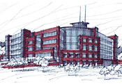
National Weather Center
NSSL combined facilities with the National Weather Service and several key university weather organizations also focused on severe weather research. The National Weather Center is a $67 million facility that will become the premier severe weather research and forecasting complex in the world. The new building fosters collaboration and communication for the weather researchers and forecasters engaged in complimentary efforts toward better forecasts and warnings of severe and hazardous weather.
