
NOAA Assists with Post Hurricane Gustav Recovery
September 3, 2008
High resolution (Credit: NOAA)
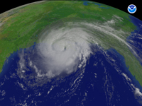
Responders from NOAA are on the move as residents and businesses in Louisiana, Mississippi, Alabama and Texas assess the impacts of Hurricane Gustav.
NOAA's National Geodetic Survey has taken thousands of aerial photographs to provide a snapshot of the physical damage to man-made infrastructure and property as well as the changes to natural shoreline and coastal areas.
These photographs are extremely useful to coastal planners and scientists who study the impacts of storm surge and winds on coastal areas that are both developed as well as undeveloped natural habitat areas. The photos, which are posted to NOAA's Emergency Response Imagery Web site as they become available after each flight under the link for Hurricane Gustav (2008), also are popular with the public who can often get a close up look at their own property if it is the flight path.
NOAA, working with Google Earth™, has made these images available to the public for several years, and when Hurricane Katrina struck in August, 2005, the Web site drew in excess of 72 million visitors checking the images and downloading over 51 million images.
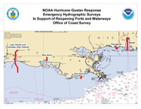
While aircraft are looking above the water level, NOAA's Navigational Response Teams (NRTs) — small teams of hydrographic surveyors operating from portable boats — have already been requested to survey areas critical to the flow of energy related commerce in the region.
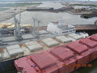
NOAA boats have been asked to certify that navigational waterways are clear for passage in Port Fourchon, Lake Charles, the Port of Iberia and the Atchafalaya River entrance and bar in Louisiana. NOAA also has been requested to survey Pascagoula, Miss. NOAA will be conducting these surveys in partnership with other federal agencies including the U.S. Coast Guard, the Army Corps of Engineers, and Federal Emergency Management Agency.
When hurricanes and strong storms make landfall they often bring with them stronger than normal ocean currents that can shift navigational channels and bring debris that can threaten the ability of vessels to navigate safely in these channels. NRTs utilize small boats that can quickly survey ports and channels to update nautical charts allowing marine transportation to resume immediately following a hurricane or other disaster. NRT teams consists of a three-person crew that uses some of the latest technology to quickly assess storm damage, identify submerged hazards or obstructions, and restore safe navigational access.
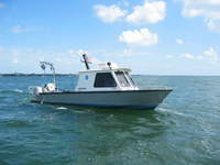
NOAA’s NRTs feature sonar equipment to detect obstructions on the ocean floor.
High resolution (Credit: NOAA)
NOAA NRT boats use sonar technology to locate and chart obstructions for safe navigation. The type of sonar that is used most often — side scan sonar — provides photograph-like imagery of the seafloor to view wreckage and debris below the surface. Some NOAA NRTs also operate a multi-beam sonar, a technology that provides full bottom coverage to create a three dimensional image of the seafloor for ocean depths on nautical charts.
NOAA's National Weather Service has been instrumental in assisting in the preparations and pre-placement of NOAA response assets with local meteorologists conducting webinars and phone briefings not only for other parts of NOAA but for all the many federal agencies preparing for storm management and response. The information has been useful in securing ports all along the Gulf Coast in accordance with weather plans developed in the past three years.
Vessels pinned against railroad bridge next to I-10 overpass in New Orleans, La.
High resolution (Credit: U.S. Coast Guard)
Also standing by, but not called upon for assistant yet, are NOAA HAZMAT teams from the Office of Response and Restoration. NOAA, through the Office of Response and Restoration, is part of the multi-agency response team providing oil spill trajectories and environmental data so that quick decisions can be made on where to collect oil and what measures can be taken to protect critical environmental resources.
Should a HAZMAT situation develop the federal on-scene coordinators rely on NOAA’s ability to provide accurate and timely on-scene scientific support, overflights, meteorological data and modeling. The NOAA scientific team assists with spill response, information management, search and rescue missions, vessel groundings, lost or sunken oil platforms, releases from coastal industrial facilities, and other impacts from hurricanes.
NOAA understands and predicts changes in the Earth's environment, from the depths of the ocean to the surface of the sun, and conserves and manages our coastal and marine resources.