
NOAA Debuts "Nautical Charts" As New Elementary Multimedia Educational Tool
March 28, 2008
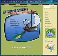
NOAA's multimedia elementary educational program, Nautical Charts.
High Resolution (Credit: NOAA)
NOAA's National Ocean Service is launching today a new multimedia elementary educational program, Nautical Charts, at the annual meeting of the National Science Teachers Association in Boston.
Designed in cooperation with NOAA's Office of Coast Survey for students at the third through fifth grade level, the media rich activity teaches young people about charting and navigation. Nautical Charts is available online at http://oceanservice.noaa.gov/education/nautical_charts/.
The activity uses animation to teach chart symbols, safe boating, and why nautical charts are important. Students have access to movies, sounds, pictures, and links to other resources. This activity uses the same characters and methodology employed in a similar multimedia tool, Sea Floor Mapping, launched last year online at http://oceanservice.noaa.gov/education_new/seafloor-mapping/welcome.html.
“NOAA is delighted to be able to make available another marine science elementary educational tool,” said Louisa Koch, director of NOAA's Office of Education. “We are working hard at expanding our offerings so that marine science activities can become an increasing part of our nation's science educational efforts at all levels.”
"We're excited about this program," said Katie Ries, deputy director of NOAA's Office of Coast Survey. "We hope that this will spark a lifelong interest in navigation, the ocean and its many mysteries."
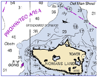
NOAA nautical chart.
The multimedia offering is interactive and challenges students to solve a mystery as they encounter a message in a bottle that includes a scrap of nautical chart from Cape Hatteras. The mystery deepens through the message’s reference to a gold ring. Students follow a series of questions and a scavenger hunt to uncover nautical chart basics and find the location of the ring.
The activity concludes with participants learning about the history and artifacts of the U.S.S. Monitor shipwreck, now part of the Monitor National Marine Sanctuary. A gold ring, from a crew member, was found in the Monitor's gun turret and now resides at the Mariner’s Museum in Newport News, Va.
One of NOAA’s goals is to support the nation’s commerce with information for safe, efficient, and environmentally sound marine transportation. The mandate to create nautical charts of the nation's coasts dates back to 1807, when President Thomas Jefferson ordered a survey of the young nation's coast. Today, NOAA’s Office of Coast Survey remains the primary agency responsible for constructing and maintaining the nation's suite of nautical charts.
Nautical Charts is being launched in conjunction with the National Science Teachers Association conference in Boston, Mass. Each year thousands of science educators meet at this conference to bring the very latest science content, research findings, and teaching techniques to the classroom teacher. NOAA's National Ocean Service is an active partner with NSTA in the development of teacher training materials using NOAA content.
The National Oceanic and Atmospheric Administration, an agency of the U.S. Commerce Department, is dedicated to enhancing economic security and national safety through the prediction and research of weather and climate-related events and information service delivery for transportation, and by providing environmental stewardship of our nation's coastal and marine resources. Through the emerging Global Earth Observation System of Systems (GEOSS), NOAA is working with its federal partners, more than 70 countries and the European Commission to develop a global monitoring network that is as integrated as the planet it observes, predicts and protects.