Treaties Between the U.S. and Mexico
The Treaty of February 2, 1848 established the United States-Mexico international boundary. The treaty of December 30, 1853 modified the boundary as it exists today. |
The Convention of July 29, 1882 established another temporary commission to resurvey and place additional monuments along the western land boundary from El Paso, Texas/Ciudad Juárez, Chihuahua to San Diego, California/Tijuana, Baja California. |
The Convention of November 12, 1884 established the rules for determining the location of the boundary when the meandering rivers transferred tracts of land from one bank of the river to the other. |
The Convention of March 1, 1889 established the International Boundary Commission (IBC) to apply the rules in the 1884 Convention and was modified by the Banco Convention of March 20, 1905 to retain the Rio Grande and the Colorado River as the international boundary. |
The Convention of May 21, 1906 provides for the distribution between the United States and Mexico of the waters of the Rio Grande in the international reach of the river between the El Paso-Juárez Valley and Fort Quitman, Texas. In the |
The Convention of February 1, 1933, the two governments agreed to jointly construct, operate and maintain, through the IBC, the Rio Grande Rectification Project, which straightened, stabilized and shortened the river boundary in the El Paso - Juárez area. |
The Treaty of February 3, 1944. Water Treaty for the "Utilization of Waters of |
|
The Treaty of November 23, 1970 resolved all pending boundary |
Copies of these treaties are available at major libraries. If you cannot find the treaty you are interested in locally, please contact us and we will provide copies of those that we may have available. For Questions regarding these treaties contact Sally Spener at (915) 832-4175 |
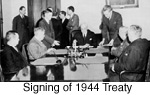 the Colorado and Tijuana Rivers and of the Rio Grande" distributed the waters in the international segment of the Rio Grande from Fort Quitman, Texas to the Gulf of Mexico. This treaty also authorized the two countries to construct operate and maintain dams on the main channel of the Rio Grande. The 1944 treaty also changed the name of the IBC to the International Boundary And Water Commission (IBWC), and in Article 3 the two governments entrusted the IBWC to give preferential attention to the solution of all border sanitation problems.
  The
The 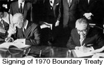 differences between the two countries, and provided for maintaining the Rio Grande and the Colorado River as the international boundary. It provides procedures designed to avoid the loss or gain of territory by either country incident to future changes in the river.