The National Water Level Program (NWLP) and the
National Water Level Observation Network (NWLON)
The National Water Level Program
 The National Oceanic and Atmospheric Administration (NOAA)/National Ocean Service's (NOS) Center for Operational Oceanographic Products and Services (CO-OPS) manages the National Water Level Program (NWLP) to meet NOAA's mission and goal requirements for water-level information. The NWLP is the foundation for major observational programs within NOS and serves as a component of the Federal backbone for the Integrated Sustained Ocean Observing System (IOOS.) The NWLP consists of networks of long-term and short-term water-level stations and is an "end-to-end" system of data collection, quality control, data management and product delivery. The NWLP serves as a water level datum reference system for the Nation. The tide and water-level datums derived from the NWLP have traditionally been important primarily for navigation and shoreline boundary purposes. For example, the tidal datum of Mean Lower Low Water (MLLW) is used as the reference datum, or Chart Datum, for U.S. nautical chart products in tidal waters. Similarly, Mean High Water (MHW) is used as the reference datum for the National Shoreline.
The National Water Level Observation Network
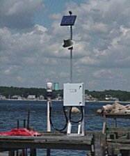
The fundamental observational component of the NWLP is the National Water Level Observation Network (NWLON). The NWLON is a network of 175 long-term, continuously operating water-level stations throughout the USA, including its island possessions and territories and the Great Lakes. The NWLON has expanded over time in response to increasing national and local needs. NWLON stations are the foundation for reference stations for NOAA's tide prediction products, and serve as controls in determining tidal datums for all short-term water-level stations.  Technological advancements in sensors, data collection and data communications have enabled routine real-time automated and event-driven data acquisition using the GOES satellite. NWLON data-collection platforms are now capable of measuring other oceanographic parameters in addition to water levels, including meteorological parameters. Because of these advancements, the application of NWLON data and products has broadened. For instance, the NWLON is a key part of the NOAA Tsunami Warning System and the NOAA Storm Surge Warning System. NWLON stations support Physical Oceanographic Real-Time Systems (PORTS) in major ports and harbors. NWLON stations have standard configurations of water level sensors (including backup sensors), backup and primary data-collection platforms, solar panel power, GOES satellite radios, and telephone modems. The figure below shows a typical NWLON station. Sensors are calibrated and vertically referenced to nearby networks of benchmarks. The data continuity, the vertical stability and careful referencing of NWLON stations have enabled the data to be used to estimate relative sea-level trends for the Nation.
Other NWLP Applications
In addition to their traditional applications, water-level data tprovide several other beneficial applications and services.  CO-OPS recently created the Coastal Oceanographic Applications and Services of Tides And Lakes(COASTAL)Program to focus on non-navigational applications of the NWLP. The COASTAL Program works with internal and external partners to provide "value-added" products and services to local and regional coastal managers and users. Some of these applications include beneficial uses of dredged material, coastal planning, monitoring coastal wetland loss and marsh restoration, storm-surge monitoring, evacuation route planning, emergency preparedness, and HAZMAT response. The COASTAL Program fosters synergy between NOS's water-level and geodetic programs. The ability to use modern surveying techniques, such as GPS surveys, in conjunction with water-level information has resulted in improved baseline information for all of these applications.