NWS Paducah Photo Gallery
Photos were sent in by storm chasers or weather enthusiasts (Thank you!).
Tornado photos
 Photo showing a weak tornado that briefly
touched down about 7 miles north of Pinckneyville, Illinois, and produced no damage. This
photo was taken by Connie Williams on the afternoon of May 31, 2001. (Click on
photo for full size). More
details.
Photo showing a weak tornado that briefly
touched down about 7 miles north of Pinckneyville, Illinois, and produced no damage. This
photo was taken by Connie Williams on the afternoon of May 31, 2001. (Click on
photo for full size). More
details.
 Photo of a weak tornado taken near Rend Lake in southern Illinois
on April 12, 2005. Photo courtesy of Steve Hamilton. More details.
Photo of a weak tornado taken near Rend Lake in southern Illinois
on April 12, 2005. Photo courtesy of Steve Hamilton. More details.
 Photo of the same tornado shown in the preceding photo, taken
from Sesser, Illinois. Photo taken by Deon Seiler. More details.
Photo of the same tornado shown in the preceding photo, taken
from Sesser, Illinois. Photo taken by Deon Seiler. More details.
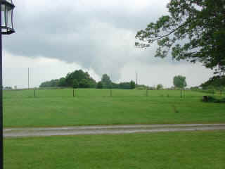 Photo of a weak tornado in eastern Todd County, KY on May 30, 2004. Photo
taken by Nena Francies. More details.
Photo of a weak tornado in eastern Todd County, KY on May 30, 2004. Photo
taken by Nena Francies. More details.
 Photo of F-2 tornado passing near Hopkins County Central High
School, near Madisonville, KY on May 30, 2004. Photo from a video clip taken by Steve and
Ann Moss. More
details.
Photo of F-2 tornado passing near Hopkins County Central High
School, near Madisonville, KY on May 30, 2004. Photo from a video clip taken by Steve and
Ann Moss. More
details.
 Photo of a weak tornado about 4 miles east of Hanson, KY near
Madisonville on June 1, 2004. Photo courtesy of David and Amy Hill. More details.
Photo of a weak tornado about 4 miles east of Hanson, KY near
Madisonville on June 1, 2004. Photo courtesy of David and Amy Hill. More details.
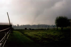 Photo of the fatal F-3 Wayne County, Illinois
tornado on April 21, 2002. Photo by Mary Hurley. More details.
Photo of the fatal F-3 Wayne County, Illinois
tornado on April 21, 2002. Photo by Mary Hurley. More details.
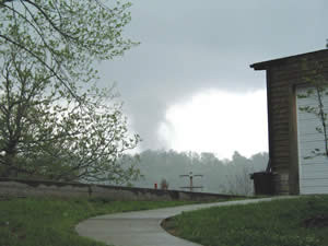 Photo of a long-track, violent tornado near
Van Buren, Missouri on April 24, 2002. Photo courtesy of Mike Gossett, National Park
Service. More details.
Photo of a long-track, violent tornado near
Van Buren, Missouri on April 24, 2002. Photo courtesy of Mike Gossett, National Park
Service. More details.
Funnel Cloud Photos
 Photo taken near Jackson, MO on April 12, 2005 by Nick Palisch. More details.
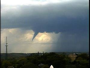 Photo taken from video from the KFVS-12 television towercam in
Cape Girardeau, MO on April 12, 2005. Photo courtesy of KFVS-12. More details.
Photo taken from video from the KFVS-12 television towercam in
Cape Girardeau, MO on April 12, 2005. Photo courtesy of KFVS-12. More details.
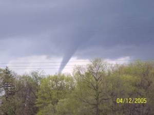 Photo taken near Gordonville, MO of the same funnel cloud as in
the previous two photos on April 12, 2005. Photo courtesy of KFVS-12 television.
Photo taken near Gordonville, MO of the same funnel cloud as in
the previous two photos on April 12, 2005. Photo courtesy of KFVS-12 television.
Numerous additional photos of wall clouds, funnel clouds, and funnel cloud look-alikes are in the photo gallery of the May 30 and June 1, 2004 storm events.
Lightning Photos
 Photo taken June 1, 2004 near Eldorado, IL by Lee
Allen.
Photo taken June 1, 2004 near Eldorado, IL by Lee
Allen.
2001 Lightning Photos (click on photos for full size). First photo shows where a lightning strike blew a hole in the ground around the roots of a tree, then travelled to a nearby house through pipes. The strike occurred around 8:15 P.M. on August 9, in the Jackson County community of Makanda. Photo courtesy of Ron Hertter, Jr. of the Carbondale (IL) EMA. Second photo below, from Mike Holland, was taken near Hurst, IL in July. Third photo from John Diebolt was taken in southern Illinois on July 3.


View a satellite photo taken on January 9, 2001, showing where snow covers the ground over parts of Illinois and Indiana.
Photos of May 23, 2000 Storms (taken in Cape Girardeau County, MO and Union County, IL)
Thanks to John Diebolt and Kevin Teegardner for contributing these excellent photos.


Most of the photos below were taken in southern Illinois in 1998 and 1999.
Lightning Photos


Distant Thunderstorm (Cumulonimbus cloud) Photos


Shelf clouds, mammatus clouds, and close-ups of thunderstorm cloud bases


Miscellaneous Other Weather Photos


