|
|
 |

"The
greatest potential for loss of life related to a hurricane is from the storm surge."
Learn about the Experimental Probabilistic Storm Surge Products for 2007
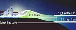 Storm
surge is simply water that is pushed toward the shore by the force of the winds
swirling around the storm. This advancing surge combines with the normal tides
to create the hurricane storm tide, which can increase the mean water level
15 feet or more. In addition, wind driven waves are superimposed on the storm
tide. This rise in water level can cause severe flooding in coastal areas, particularly
when the storm tide coincides with the normal high tides. Because much of the
United States' densely populated Atlantic and Gulf Coast coastlines lie less
than 10 feet above mean sea level, the danger from storm tides is tremendous. Storm
surge is simply water that is pushed toward the shore by the force of the winds
swirling around the storm. This advancing surge combines with the normal tides
to create the hurricane storm tide, which can increase the mean water level
15 feet or more. In addition, wind driven waves are superimposed on the storm
tide. This rise in water level can cause severe flooding in coastal areas, particularly
when the storm tide coincides with the normal high tides. Because much of the
United States' densely populated Atlantic and Gulf Coast coastlines lie less
than 10 feet above mean sea level, the danger from storm tides is tremendous.
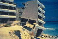
| The
level of surge in a particular area is also determined by the slope of the
continental shelf. A shallow slope off the coast (right, top picture) will
allow a greater surge to inundate coastal communities. Communities with
a steeper continental shelf (right, bottom picture) will not see as much
surge inundation, although large breaking waves can still present major
problems. Storm tides, waves, and currents in confined harbors severely
damage ships, marinas, and pleasure boats. |
 |
 |
One
tool used to evaluate the threat from storm surge is the SLOSH
model. Emergency managers use this data from SLOSH to determine which areas
must be evacuated for storm surge. The links below provide some altered photos
that show how the intensity of the storm (as given by the Saffir-Simpson
Hurricane Scale) affects the possibility of flooding from storm surge at
two locations. Storm surge also affects rivers and inland lakes, potentially
increasing the area that must be evacuated. You can see some of these effects
by looking at simulated storm surge pictures for Brunswick,
GA, New Orleans, LA, Brooklyn,
NY, Wrightsville Beach, NC and Manteo,
NC.
In
general, the more intense the storm, and the closer a community is to the right-front
quadrant, the larger the area that must be evacuated. The problem is always
the uncertainty about how intense the storm will be when it finally makes landfall.
Emergency managers and local officials balance that uncertainty with the human
and economic risks to their community. This is why a rule of thumb for emergency
managers is to plan for a storm one category higher than what is forecast. This
is a reasonable precaution to help minimize the loss of life from hurricanes.
Wave
and current action associated with the tide also causes extensive damage. Water
weighs approximately 1,700 pounds per cubic yard; extended pounding by frequent
waves can demolish any structure not specifically designed to withstand such
forces.
 The
currents created by the tide combine with the action of the waves to severely
erode beaches and coastal highways. Many buildings withstand hurricane force
winds until their foundations, undermined by erosion, are weakened and fail. The
currents created by the tide combine with the action of the waves to severely
erode beaches and coastal highways. Many buildings withstand hurricane force
winds until their foundations, undermined by erosion, are weakened and fail.
In
estuaries and bayous, intrusions of salt water endanger the public health and
send animals, such as snakes, to flee from flooded areas and take refuge in urban
areas.
RELATED
INFORMATION
• STORM
SURGE SAFETY ACTIONS
• SLOSH
MODEL
• SAFFIR
SIMPSON HURRICANE SCALE
• HISTORIC
STORM SURGE EVENTS
RELATED
MULTIMEDIA
• MAX
MAYFIELD DISCUSSES - STORM
SURGE (0.3mb MP3 ) )
ADDITIONAL
SAFETY INFORMATION
STORM SURGE
SAFETY ACTIONS
- Minimize
the distance you must travel to reach a safe location; the further you drive
the higher the likelihood of encountering traffic congestion and other problems
on the roadways.
- Select
the nearest possible evacuation destination, preferably within your local
area, and map out your route. Do not get on the road without a planned route,
or a place to go.
- Choose
the home of the closest friend or relative outside a designated evacuation
zone and discuss your plan with them before hurricane season.
- You may also
choose a hotel/motel outside of the vulnerable area.
- If neither of
these options is available, consider the closest possible public shelter,
preferably within your local area.
- Use the evacuation
routes designated by authorities and, if possible, become familiar with your
route by driving it before an evacuation order is issued.
- Contact your
local emergency management office to register or get information regarding
anyone in your household whom may require special assistance in order to evacuate.
- Prepare a separate
pet plan, most public shelters do not
accept pets.
- Prepare your
home prior to leaving by boarding up doors and windows, securing or moving
indoors all yard objects, and turning off all utilities.
- Before leaving,
fill your car with gas and withdraw extra money from the ATM.
- Take all prescription
medicines and special medical items, such as glasses and diapers.
- If your family
evacuation plan includes an RV, boat or trailer, leave early. Do not wait
until the evacuation order or exodus is well underway to start your trip.
- If
you live in an evacuation zone and are ordered to evacuate by state or local
officials, do so as quickly as possible. Do not wait or delay your departure,
to do so will only increase your chances of being stuck in traffic, or even
worse, not being able to get out at all.
- Expect
traffic congestion and delays during evacuations. Expect and plan for significantly
longer travel times than normal to reach your family's intended destination.
- Stay
tuned to a local radio or television station and listen carefully for any
advisories or specific instructions from local officials. Monitor your NOAA
Weather Radio.
HISTORIC
STORM SURGE EVENTS
- Opal
1995
Hurricane Opal made landfall near Pensacola Beach, Florida as a Category 3
hurricane. The storm caused extensive storm surge damage from Pensacola Beach
to Mexico Beach (a span of 120 miles) with a maximum storm tide of 24 feet,
recorded near Fort Walton Beach. Damage estimates for Opal were near $3 billion.
More...
- Hugo
1989
Devastated the West Indies and the Southeastern United States, including South
Carolina cities Charleston and Myrtle Beach. Hugo was responsible for sixty
deaths and $7 billion in damages, with a storm surge estimated at 19.8 feet
at Romain Retreat, South Carolina. More...
- Camille
1969
A Category 5 hurricane, the most powerful on the Saffir/Simpson Scale with
maximum winds of more than 200mph devastated the Mississippi coast. The final
death count for the U.S. is listed at 256. This includes 143 on the Gulf coast
and another 113 from the Virginia floods. More...
- Audrey
1957
There were 390 deaths as the result of a storm surge
in excess of 12 feet, which inundated the flat coast of southwestern Louisiana
as far as 25 miles inland in some places. More...
- New
England 1938
A fast-moving Category 3 hurricane (the Long Island Express) that struck
Long Island and New England with little warning on September 21. A storm surge
of 10 to 12 ft inundated the coasts of Rhode Island, Connecticut, southeastern
Massachusetts, and Long Island, NY, especially in Narragansett Bay and Buzzards
Bay. Six hundred people died due to the storm. More...
- Okeechobee
1928
A Category 4 hurricane that made landfall near Palm Beach on September 16
with a central pressure of 929 mb. The center passed near Lake Okeechobee,
causing the lake to overflow its banks and inundate the surrounding area to
a depth of 6 to 9 ft. 1,836 people died in Florida, primarily due to the lake
surge. More...
- Galveston
1900
More than
6,000 people died when hurricane storm tides (the surge plus the astronomical
tide) of 8-15 feet inundated the entire island city of Galveston, TX. More...
|
|

 |
Storm
Surge
Safety Actions
EVACUATION INFORMATION |
|
|
|

|
Minimize
the distance you must travel to reach a safe location; the further
you drive the higher the likelihood of encountering traffic
congestion and other problems on the roadways. |
|
|
Select
the nearest possible evacuation destination, preferably within
your local area, and map out your route. Do not get on the road
without a planned route, or a place to go. |
|
|
Choose
the home of the closest friend or relative outside a designated
evacuation zone and discuss your plan with them before hurricane
season. |
|
|
You
may also choose a hotel/motel outside of the vulnerable area. |
|
|
If
neither of these options is available, consider the closest
possible public shelter, preferably within your local area. |
|
Use
the evacuation routes designated by authorities and, if possible,
become familiar with your route by driving it before an evacuation
order is issued. |
|
Contact
your local emergency management office to register or get information
regarding anyone in your household whom may require special
assistance in order to evacuate. |
|
|
Prepare
a separate pet plan, most
public shelters do not accept pets. |
|
|
Prepare
your home prior to leaving by boarding up doors and windows,
securing or moving indoors all yard objects, and turning off
all utilities. |
|
Before
leaving, fill your car with gas and withdraw extra money from
the ATM. |
|
Take
all prescription medicines and special medical items, such as
glasses and diapers. |
|
If
your family evacuation plan includes an RV, boat or trailer,
leave early. Do not wait until the evacuation order or exodus
is well underway to start your trip. |
|
If
you live in an evacuation zone and are ordered to evacuate by
state or local officials, do so as quickly as possible. Do not
wait or delay your departure, to do so will only increase your
chances of being stuck in traffic, or even worse, not being
able to get out at all. |
|
Expect
traffic congestion and delays during evacuations. Expect and
plan for significantly longer travel times than normal to reach
your family's intended destination. |
|
Stay
tuned to a local radio or television station and listen carefully
for any advisories or specific instructions from local officials.
Monitor your NOAA Weather
Radio. |
|
|