Tropical Cyclone Report
Hurricane Isabel
6 - 19 September 2003
Jack Beven and Hugh Cobb
National Hurricane Center
19 December 2003
Revised: 16 January 2004
Hurricane Isabel was a long-lived Cape Verde
hurricane that reached Category 5 status on the Saffir-Simpson
Hurricane Scale. It made landfall near Drum Inlet on the Outer
Banks of North Carolina as a Category 2 hurricane. Isabel is
considered to be one of the most significant tropical cyclones to
affect portions of northeastern North Carolina and east-central
Virginia since Hurricane Hazel in 1954 and the Chesapeake-Potomac
Hurricane of 1933.
a. Synoptic History
Isabel formed from a tropical wave that moved
westward from the coast of Africa on 1 September. Over the next
several days, the wave moved slowly westward and gradually became
better organized. By 0000 UTC 5 September, there was sufficient
organized convection for satellite-based Dvorak intensity estimates
to begin. Development continued, and it is estimated that a
tropical depression formed at 0000 UTC 6 September, with the
depression becoming Tropical Storm Isabel six hours later. The
"best track" chart of Isabel is given in Figure 1,
with the wind and
pressure histories shown in Figure 2 and Figure 3,
respectively. The best
track positions and intensities are listed in Table 1.
Isabel turned west-northwestward on 7 September and
intensified into a hurricane. Strengthening continued for the next
two days while Isabel moved between west-northwest and northwest.
Isabel turned westward on 10 September and maintained this motion
until 13 September on the south side of the Azores-Bermuda High.
Isabel strengthened to a Category 5 hurricane on 11 September with
maximum sustained winds estimated at 145 kt at 1800 UTC that day.
After this peak, the maximum winds remained in the 130-140 kt range
until 15 September. During this time, Isabel displayed a persistent
35-45 n mi diameter eye.
Isabel approached a weakness in the western portion
of the Azores-Bermuda High, which allowed the hurricane to turn
west-northwestward on 13 September, northwestward on 15, September,
and north-northwestward on 16 September. The latter motion would
continue for the rest of Isabel's life as a tropical cyclone.
Increased vertical wind shear on 15 September caused
Isabel to gradually weaken. The system weakened below major
hurricane status (96 kt or Category 3 on the Saffir-Simpson
Hurricane Scale) on 16 September. It maintained Category 2 status
with 85-90 kt maximum winds for the next two days while the overall
size of the hurricane increased. Isabel made landfall near Drum
Inlet, North Carolina near 1700 UTC 18 September as a Category 2
hurricane, then weakened as it moved across eastern North Carolina.
It weakened to a tropical storm over southern Virginia, then lost
tropical characteristics as it moved across western Pennsylvania on
19 September. Extratropical Isabel moved northward into Canada and
was absorbed into a larger baroclinic system moving eastward across
south central Canada early the next day.
b. Meteorological Statistics
Observations in Isabel (Figure 2 and Figure 3)
include
satellite-based Dvorak technique intensity estimates from the
Tropical Analysis and Forecast Branch (TAFB), the Satellite
Analysis Branch (SAB) and the U. S. Air Force Weather Agency
(AFWA). Also included are flight-level and dropwindsonde
observations from flights by the 53rd Weather
Reconnaissance Squadron of the U. S. Air Force Reserve Command, the
NOAA Aircraft Operations Center, and a Canadian research aircraft.
Observations from ships (Table 2), land stations, and data buoys
(Table 3) are included where appropriate. Microwave satellite
imagery from the National Aeronautics and Space Administration
(NASA) Tropical Rainfall Measuring Mission (TRMM), the NASA
QuikSCAT, and the Defense Meteorological Satellite Program (DMSP)
satellites were also useful in tracking Isabel.
The Air Force Reserve Hurricane Hunters made 39
center fixes during Isabel. The NOAA Hurricane Hunters made two
formal center fixes and flew seven research missions into the
storm. The highest winds measured by the aircraft were 158 kt (Air
Force at 700 mb) and 157 kt (NOAA at 8400 ft) between 1700-1730 UTC
13 September. A 156-kt flight-level wind (700 mb) was also observed
at 1719 UTC 12 September. Stronger winds were observed on eyewall
dropsondes, with a maximum of 203 kt reported at 806 mb (4500 ft)
at 1753 UTC 13 September. This is the strongest wind ever observed
in an Atlantic hurricane, although it likely does not represent a
1-min average.
Comparison of the aircraft and satellite data makes
the peak intensity of Isabel somewhat speculative. Aircraft data on
12 September indicate that Isabel had winds near 140 kt. However,
the maximum intensity based on satellite imagery was reached on 11
September before the first reconnaissance mission, and the
satellite signature was weaker at the time of the first mission.
The maximum intensity estimate of 145 kt on 11 September is based
on the aircraft data of 12 September and the stronger satellite
signature on the previous day. The minimum central pressure of 915
mb on 11 September has a similar basis.
Isabel's intensity is also somewhat uncertain during
16-18 September. During this time, a large outer eyewall formed,
which disrupted the inner core wind structure. Dropsonde data
indicated that the usual 90% reduction for 700 mb winds to the
surface in the eyewall was not valid, with the actual reductions
being closer to 70-75%. Both Air Force and NOAA aircraft measured
118-kt flight-level winds in the northeast eyewall just as Isabel
was making landfall, which using the 90% reduction would support
105 kt sustained surface winds. However, using a 75% reduction
gives a sustained surface wind of near 90 kt, which is in better
agreement with maximum surface winds estimated by a dropsonde (83
kt) and the Stepped Frequency Microwave Radiometer on the NOAA
aircraft (90 kt) near the same time. Based on this, the best
estimate of the landfall intensity is 90 kt.
Isabel brought hurricane conditions to portions of
eastern North Carolina and southeastern Virginia. The highest
observed wind on land (Table 3) was sustained at 69 kt with a gust
to 85 kt at an instrumented tower near Cape Hatteras, North
Carolina at 1622 UTC 18 September. Another tower in Elizabeth City,
North Carolina reported 64-kt sustained winds with a gust to 84 kt
at 1853 UTC that day. The National Ocean Service (NOS) station at
Cape Hatteras reported 68-kt sustained winds with a gust to 83 kt
before contact was lost. The Coastal Marine Automated Stations
(C-MAN) at Chesapeake Light, Virginia and Duck, North Carolina
reported similar winds. Elsewhere in Virginia, Gloucester Point
reported 60-kt sustained winds with a gust to 79 kt at 2200 UTC 18
September, while the Norfolk Naval Air Station reported 50-kt
sustained winds with a gust to 72 kt at 2100 UTC that day.
Unofficial reports from the affected area include a gist of 102 kt
at Kitty Hawk, North Carolina, a gust of 93 kt from Gwynns Island,
Virginia, a gust of 91 kt at Ocracoke, North Carolina, and a gust
of 88 kt at New Bern, North Carolina. The wind record from the most
seriously affected areas is incomplete, as several observing
stations were either destroyed or lost power as Isabel passed.
Isabel brought tropical-storm conditions to a large
area from eastern North Carolina northward to the eastern Great
Lakes and western New England. The C-MAN station at Thomas Point,
Maryland reported 42 kt sustained winds with a gust to 58 kt at
0850 UTC 19 September. Reagan National Airport in Washington, DC
reported 39-kt sustained winds with a gust to 50 kt at 0139 UTC
that day. Sustained tropical storm-force winds were reported at
Kennedy and LaGuardia Airports in New York City, while a gust of 52
kt was reported in Middletown, Pennsylvania. Extratropical Isabel
brought gale-force winds to portions of the eastern Great Lakes and
southeastern Canada.
Shipping for the most part avoided Isabel. The most
significant ship report was from the ZIPR7 (name unknown), which
reported 52-kt winds at 1200 UTC 17 September (Table 2).
Additionally, NOAA buoy 41002 reported a 10-min average wind of 52
kt with a gust to 70 kt at 0540 UTC 18 September. Two NOAA data
buoys broke loose as the storm passed and had to be replaced.
The lowest pressure observed by reconnaissance
aircraft was 920 mb at 1712 and 1901 UTC 12 September. The lowest
pressures observed on land were unofficial reports of 957 mb at
Arrowhead Beach, North Carolina, and 958 mb from a storm chaser in
Hobucken, North Carolina. The lowest pressures from official
observation sites were 962.8 mb from an instrumented tower in
Atlantic Beach, North Carolina at 1645 UTC 18 September, and 963.5
mb at Washington, North Carolina at 1944 UTC that day.
Isabel produced storm surges of 6-8 ft above normal
tide levels near the point of landfall along the Atlantic coast of
North Carolina. Farther north, storm surge values ranged from 4-6
ft along the Virginia coast, 2-4 ft along the Maryland, Delaware
and New Jersey shorelines, and 1-2 ft along the coast of Long
Island and in the Long Island sound.
In the North Carolina estuaries, storm surge values
were generally 4-6 ft above normal tide levels over the eastern
portions of the Pamlico Sound and most of the Albemarle Sound.
Values of 6-10 ft above normal tide levels were observed in the
western end of the Pamlico Sound with a maximum value of 10.5 ft
reported on the Neuse River in Craven County (Table 3).
Storm surges of 3-5 ft above normal tide levels were
observed over the central portions of the Chesapeake Bay and 5-6 ft
over the southern portion of the Bay in the vicinity of Hampton
Roads, Virginia. Surge values of 6-8 ft above normal levels were
observed in the upper reaches of the Chesapeake Bay near Annapolis
and Baltimore, Maryland and in most of the main stem rivers
draining into the Chesapeake Bay. Even higher surges occurred at
the heads of the rivers, with values of 8.5 ft above normal levels
at the Richmond City locks along the James River in Virginia and
nearly 8 ft along the Potomac River in Washington, D.C. Water
levels exceeded previous record levels established in the
Chesapeake-Potomac Hurricane of 1933 in Washington, D.C., Baltimore
and Annapolis.
Storm surges in Delaware Bay were generally 3-4 ft at
the mouth of the bay and 5-6.5 ft at the head of the bay and along
the Delaware River in the vicinity of Philadelphia,
Pennsylvania.
Rainfall from Hurricane Isabel averaged 4-7 in over
large portions of eastern North Carolina, east-central Virginia and
Maryland. Rainfall totals of 8-12 in with locally higher amounts
occurred in the Shenandoah valley in northern Virginia. Upper
Sherando, Virginia, reported a storm total of 20.20 in (Table 4).
Lesser amounts in the 2-4 in range occurred elsewhere over eastern
Virginia and the Delmarva Peninsula.
One tornado occurred in association with Hurricane
Isabel. It touched down in the Ocean View section of Norfolk,
Virginia at approximately 2200 UTC 18 September and was verified
only by visual confirmation from law enforcement officials. No
Fujita scale rating has been assigned to the tornado since its
damage could not be distinguished from the extensive
hurricane-related wind damage in the area.
c. Casualty and Damage Statistics
Isabel is directly responsible for 16 deaths: 10 in
Virginia, and 1 each in North Carolina, Maryland, New Jersey, New
York, Rhode Island, and Florida. The deaths in Florida and Rhode
Island were drownings in high surf generated by Isabel. Isabel was
indirectly responsible for 34 deaths: 22 in Virginia, 6 in
Maryland, 2 in North Carolina and Pennsylvania, and 1 each in New
Jersey and the District of Columbia.
Isabel caused widespread wind and storm surge damage
in coastal eastern North Carolina and southeastern Virginia. Storm
surge damage also occurred along Chesapeake Bay and the associated
river estuaries, while wind damage occurred over portions of the
remaining area from southern Virginia northward to New York. The
current estimate for insured property damage is $1.685 billion -
$925 million in Virginia, $410 million in Maryland, $170 million in
North Carolina, $80 million in Pennsylvania, $45 million in New
York, $25 million in New Jersey, $20 million in Delaware, and $10
million in West Virginia. The total damage for Isabel is estimated
to be about twice that of the insured damage, or $3.37 billion.
d. Forecast and Warning Critique
The track of Isabel was in general well forecast.
Average official track errors (with the number of cases in
parentheses) for Hurricane Isabel were 22 (51), 39
(49), 52 (47), 60 (45), 80 (41), 104 (37), and 146 (33) n mi
for the 12, 24, 36, 48, 72, 96, and 120 h forecasts,
respectively1.
These errors are much lower than the average official
track errors for the 10-yr period 1993-20022
(45, 81, 116, 150, 225, 282, and 374 n mi, respectively)
(Table 5) - 50-65 % smaller than the average forecast errors at all
times. The track forecasts also showed tremendous skill when
compared to the errors of the Climatology-Persistence (CLP5) model
(32, 68, 109, 148, 231, 350, and 537 n mi for the 12, 24, 36, 48,
72, 96, and 120 h forecasts, respectively) - including an almost
75% improvement at 120 h. Overall, the official track forecasts had
smaller errors than the dynamical models. However, three ensemble
methods that combine the forecasts of the dynamical models (GUNS,
GUNA, and FSSE) had smaller errors than the official forecasts.
There appear to be three primary reasons for the
excellent track forecasts. First, Isabel was a large and strong
hurricane, and this type of tropical cyclone is generally easier to
forecast.
Second, Isabel moved slowly through the central and
eastern Atlantic in a relatively predictable steering pattern.
While an initial northwestward motion was not as well forecast as
other parts of the track, the forecasts did correctly anticipate
that Isabel would turn westward and maintain that course for
several days.
Third, when Isabel reached the western Atlantic,
synoptic surveillance missions began using both the NOAA
Gulfstream-IV jet and Air Force Reserve aircraft. These mission
helped resolve a complex steering flow pattern around Isabel.
Preliminary estimates from the Hurricane Research Division indicate
that the synoptic surveillance data improved the track forecasts of
the NWS Global Forecast System model (AVNO in Table 5) by as much
as 40% at 120 h. Qualitative examination of forecasts from the
NOGAPS (NGPS) and UKMET models (UKM) also suggest forecast track
improvement due to the data.
The landfall forecasts were exceptionally accurate.
The track forecast errors verifying at 1800 UTC 18 September (1 h
after landfall) had errors of 6, 12, 6, 16, 31, 86, and 118 n mi
for the 12, 24, 36, 48, 72, 96, and 120 h forecasts,
respectively.
The intensity forecasts were less accurate than the
track forecasts. Average official intensity errors were 7, 11, 14,
17, 22, 25, and 27 kt for the 12, 24, 36, 48, 72, 96, and 120 h
forecasts, respectively, which are larger than the average official
intensity errors over the 10-yr period 1993-2002 (6, 10, 13, 15,
19, 21, and 22 kt, respectively). However, the intensity forecasts
showed skill when compared to intensity climatology and
persistence, which had errors of 8, 13, 18, 23, 29, 32, and 35 kt
for the 12, 24, 36, 48, 72, 96, and 120 h forecasts, respectively.
The greatest contributors to the intensity forecast errors included
1) underforecasting how quickly Isabel would intensify over the
eastern Atlantic, and 2) overforecasting how strong Isabel would
remain as it reached a less favorable environment in the western
Atlantic.
Table 6 lists the watches and warnings associated
with Hurricane Isabel. The accurate track forecasts and the large
size of Isabel led to longer than normal watch and warning lead
times. A hurricane watch was issued for the landfall area 50 h
before the center made landfall. A hurricane warning was issued 38
h before landfall.
Acknowledgements
Much of the data from the affected areas were
provided by the NWS Weather Forecast Offices at Wilmington,
Morehead City, and Raleigh, North Carolina, Wakefield, Sterling,
and Blacksburg, Virginia, Mount Holly, New Jersey, Upton, New York,
and Pittsburgh and State College, Pennsylvania. NOAA buoy and C-MAN
data were provided by the National Data Buoy Center. NOS data were
provided by the NOAA National Ocean Service. Remote Automated
Weather Stations (RAWS) data were provided by the National
Interagency Fire Center. USGS data were provided by the NWISWeb web
site. Other data were provided by the Weather Underground web
site.
1All
forecast verifications in this report include the depression stage of the
cyclone. National Hurricane Center verifications presented in these
reports prior to 2003 did not include the depression stage.
2Errors
given for the 96 and 120 h periods are averages over the two-year period
2001-2002.
Table 1: Best track
for Hurricane Isabel, 6-19 September 2003.
Date/Time
(UTC) | Position | Pressure
(mb) | Wind Speed
(kt) | Stage |
Lat.
(°N) | Lon.
(°W) |
| 06 / 0000 | 13.8 | 31.4 | 1009 | 30 | tropical depression |
| 06 / 0600 | 13.9 | 32.7 | 1005 | 35 | tropical
storm |
| 06 / 1200 | 13.6 | 33.9 | 1003 | 40 | " |
| 06 / 1800 | 13.4 | 34.9 | 1000 | 45 | " |
| 07 / 0000 | 13.5 | 35.8 | 994 | 55 | " |
| 07 / 0600 | 13.9 | 36.5 | 991 | 60 | " |
| 07 / 1200 | 14.4 | 37.3 | 987 | 65 | hurricane |
| 07 / 1800 | 15.2 | 38.5 | 984 | 70 | " |
| 08 / 0000 | 15.8 | 39.7 | 976 | 80 | " |
| 08 / 0600 | 16.5 | 40.9 | 966 | 95 | " |
| 08 / 1200 | 17.1 | 42.0 | 952 | 110 | " |
| 08 / 1800 | 17.6 | 43.1 | 952 | 110 | " |
| 09 / 0000 | 18.2 | 44.1 | 948 | 115 | " |
| 09 / 0600 | 18.9 | 45.2 | 948 | 115 | " |
| 09 / 1200 | 19.4 | 46.3 | 948 | 115 | " |
| 09 / 1800 | 20.0 | 47.3 | 948 | 115 | " |
| 10 / 0000 | 20.5 | 48.3 | 952 | 110 | " |
| 10 / 0600 | 20.9 | 49.4 | 952 | 110 | " |
| 10 / 1200 | 21.1 | 50.4 | 948 | 115 | " |
| 10 / 1800 | 21.1 | 51.4 | 942 | 120 | " |
| 11 / 0000 | 21.2 | 52.3 | 935 | 125 | " |
| 11 / 0600 | 21.3 | 53.2 | 935 | 125 | " |
| 11 / 1200 | 21.4 | 54.0 | 925 | 135 | " |
| 11 / 1800 | 21.5 | 54.8 | 915 | 145 | " |
| 12 / 0000 | 21.6 | 55.7 | 920 | 140 | " |
| 12 / 0600 | 21.7 | 56.6 | 920 | 140 | " |
| 12 / 1200 | 21.6 | 57.4 | 920 | 140 | " |
| 12 / 1800 | 21.7 | 58.2 | 920 | 140 | " |
| 13 / 0000 | 21.8 | 59.1 | 925 | 135 | " |
| 13 / 0600 | 21.9 | 60.1 | 935 | 130 | " |
| 13 / 1200 | 22.1 | 61.0 | 935 | 135 | " |
| 13 / 1800 | 22.5 | 62.1 | 932 | 140 | " |
| 14 / 0000 | 22.9 | 63.3 | 935 | 135 | " |
| 14 / 0600 | 23.2 | 64.6 | 939 | 135 | " |
| 14 / 1200 | 23.5 | 65.8 | 935 | 135 | " |
| 14 / 1800 | 23.9 | 67.0 | 933 | 140 | " |
| 15 / 0000 | 24.3 | 67.9 | 937 | 130 | " |
| 15 / 0600 | 24.5 | 68.8 | 940 | 125 | " |
| 15 / 1200 | 24.8 | 69.4 | 946 | 120 | " |
| 15 / 1800 | 25.3 | 69.8 | 949 | 115 | " |
| 16 / 0000 | 25.7 | 70.2 | 952 | 105 | " |
| 16 / 0600 | 26.3 | 70.5 | 955 | 100 | " |
| 16 / 1200 | 26.8 | 70.9 | 959 | 95 | " |
| 16 / 1800 | 27.4 | 71.2 | 959 | 95 | " |
| 17 / 0000 | 28.1 | 71.5 | 957 | 95 | " |
| 17 / 0600 | 28.9 | 71.9 | 957 | 95 | " |
| 17 / 1200 | 29.7 | 72.5 | 957 | 90 | " |
| 17 / 1800 | 30.6 | 73.0 | 955 | 90 | " |
| 18 / 0000 | 31.5 | 73.5 | 953 | 90 | " |
| 18 / 0600 | 32.5 | 74.3 | 956 | 90 | " |
| 18 / 1200 | 33.7 | 75.2 | 956 | 90 | " |
| 18 / 1800 | 35.1 | 76.4 | 958 | 85 | " |
| 19 / 0000 | 36.7 | 77.7 | 969 | 65 | " |
| 19 / 0600 | 38.6 | 78.9 | 988 | 50 | tropical
storm |
| 19 / 1200 | 40.9 | 80.3 | 997 | 35 | extratropical |
| 19 / 1800 | 43.9 | 80.9 | 1000 | 30 | " |
| 20 / 0000 | 48.0 | 81.0 | 1000 | 25 | " |
| 20 / 0600 | | | | | absorbed by extratropical low |
| 11 / 1800 | 21.5 | 54.8 | 915 | 145 | minimum pressure |
| 18 / 1700 | 34.9 | 76.2 | 957 | 90 | landfall at Drum Inlet, North Carolina |
Table 2: Selected ship reports with winds of at least
34 kt for Hurricane Isabel, 6-19 September 2003.
| Ship Name or Call Sign | Date/Time (UTC) | Lat.
(°N) | Lon.
(°W) | Wind dir/speed (deg/kt) | Pressure (mb) |
| Duncan
Island | 17/ 0300 | 27.4 | 68.7 | 160/42 | 1007.5 |
| Duncan
Island | 17/ 0900 | 29.1 | 67.9 | 160/45 | 1010.0 |
| ZIPR7 | 17/ 0900 | 32.0 | 68.3 | 110/45 | 1010.7 |
| ZIPR7 | 17/ 1200 | 30.2 | 67.4 | 150/52 | 1011.6 |
| Sealand
Hawaii | 17/ 1800 | 31.0 | 68.5 | 130/40 | 1010.2 |
| Galveston
Bay | 17/ 1800 | 33.4 | 76.7 | 020/37 | 1010.8 |
| Oriental
Bay | 19/ 0000 | 35.5 | 73.1 | 140/37 | 1010.6 |
| P&O Ned
Lloyd Pegasus | 19/ 0300 | 34.7 | 74.8 | 190/37 | 1010.5 |
| P&ONed Lloyd
Piraeus | 19/ 0600 | 38.9 | 72.9 | 160/45 | 1015.3 |
| James R.
Barker | 19/ 1200 | 42.2 | 81.1 | 060/42 | 1001.0 |
|
Table 3: Selected surface observations for Hurricane Isabel, 6-19 September
2003.
| | Minimum
Sea-level
Pressure | Maximum Surface Wind Speed
(kt) | |
| Location | Date/
Time
(UTC) | Press.
(mb) | Date/
Timea
(UTC) | Sust.
Windb
(kts) | Peak
Gust (kts) | Storm
Surgec
(ft) | Storm
Tided
(ft) | Rain
(storm total)
(in) |
| South Carolina |
| Springmaid Pier | | | 18/1545 | 24 | 39 | | | |
| North Carolina |
| Alligator River NWR RAWS | | | 18/1900 | 50 | | | | 3.75 |
| Atlantic Beach (Clemson/UF Tower) | 18/1645 | 962.8 | 18/1558 | 55 | 67 | | | |
| Back Island
RAWS | | | 18/1813 | | 53 | | | 1.65 |
| Beaufort
RAWS | | | 18/1815 | | 64 | | | 5.64 |
| Beaufort (NOS) | | | | | | 5.8 | 2.5 | |
| Burlington (KBUY) | | | | | 48 | | | |
| Cape Hatteras (Clemson/UF Tower) | 18/1644 | 968.2 | 18/1622 | 69 | 85 | | | |
| Cape Hatteras Pier NOSf | 18/1518 | 974.0 | 18/1518 | 68 | 83 | 7.7 | 5.6 | |
| Caswell Gamelands RAWS | | | 18/2017 | | 46 | | | 1.95 |
| Cherry Point (KNKT) | 18/1840 | 968.2 | 18/1818 | | 62 | | | 5.24 |
| Clinton (KCTZ) | | | | | 40 | | | |
| Craven Co. (Neuse river) | | | | | | | 10.5 | |
| Duke Forest RAWS | | | 18/1907 | | 53 | | | 1.70 |
| Duck Corps of
EngineersPier
NOSe | 18/1918 | 984.0 | 18/2100 | 55 | 72 | 7.8 | 4.7 | 4.72 |
| Elizabeth City (KECG) | | | 18/1543 | 51e | 64e | | | 2.72 |
| Elizabeth City (Clemson/UF Tower) | 18/1940 | 981.9 | 18/1852 | 64 | 84 | | | |
| Elizabethtown | | | 18/2320 | 22 | 43 | | | 2.26 |
| Erwin-Dunn (KHRJ) | | | | | 38 | | | |
| Fayetteville (KFAY) | | | | 35 | 50 | | | |
| Fort Bragg (KFBG) | | | | | 52 | | | |
| Fort Bragg RAWS | | | 18/2007 | | 48 | | | 1.33 |
| Franklinton (KLHZ) | | | | | 39 | | | |
| Goldsboro (KGSB) | | | | 35 | 51 | | | |
| Greensboro (KGSO) | | | | | 40 | | | |
| Greens Cross RAWS | | | 18/1708 | | 50e | | | 6.29 |
| Greenville (KPGV) | | | 18/1855 | 34 | 44 | | | 5.75 |
| Henderson (KHNZ) | | | | | 39 | | | |
| Hoffman Forest
RAWS | | | 18/1509 | | 50 | | | 2.35 |
| Laurinburg (KMEB) | | | | | 35 | | | |
| Lumberton
(KLBT) | | | 18/1921 | 32 | 45 | | | 3.39 |
| Manteo (KMQI) | 18/1743 | 982.4 | 18/1843 | 44 | 68 | | | |
| Nature Conservancy RAWS | | | 18/1658 | | 54 | | | 1.91 |
| New Bern
(KEWN) | | | 18/1608 | | 50e | | | |
| New River (KNCA) | 18/1756 | 981.7 | 18/1556 | 39 | 56 | | | 2.02 |
| Newport (KMHX) | 18/1730 | 968.9 | 18/1800 | | 46 | | | 5.87 |
| Oregon Inlet Marina NOS | | | | | | 5.4 | 4.7 | |
| Pocosin Lake NWR
RAWS | | | 18/1823 | | 64 | | | 5.94 |
| Raleigh (KRDU) | | | | | 39 | | | |
| Rocky Mount (KRWI) | | | | 35 | 54 | | | |
| Rocky Mount RAWS | | | 18/2113 | | 52e | | | 4.20 |
| Roanoke Rapidse (KRZZ) | | | 18/2147 | 38 | 55 | | | |
| Sanford (KTTA) | | | | | 43 | | | |
| Smithfield (KJNX) | | | | | 34 | | | |
| Sunny Point RAWS | | | 18/2158 | | 51 | | | 2.09 |
| Turnbull Creek RAWS | | | 18/2313 | | 41 | | | 2.19 |
| Washington
(KOCW) | 18/1944 | 963.5 | 18/1803 | 37 | 49 | | | |
| Wilmington (KILM) | 18/1843 | 990.5 | 18/2143 | 39 | 51 | | | 1.98 |
| Wilmington (Clemson/UF Tower) | 18/1730 | 990.8 | 18/1315 | | 43 | | | |
| Virginia |
| Back Bay NWR RAWS | | | 18/1935 | 38 | 53 | | | 4.12 |
| Blacksburg (WFO) | | | 19/0120 | | 34 | | | |
| Chesapeake Bay Bridge Tunnel NOS | 18/2154 | 992.4 | 18/2048 | 52 | 64 | 7.5 | 4.8 | |
| Colonial Beach NOSe | | | | | | 5.4 | 3.7
(6.5)h | |
| Culpeper (KCJR) | 19/0303 | 995.0 | | | | | | |
| Danville (KDAN) | | | 18/1922 | | 45 | | | |
| Dulles Airport (KIAD) | 19/0359 | 997.6 | 19/0122 | 32 | 42 | | | 1.96 |
| Fort Belvoir (KDAA) | | | | | | | | 2.32 |
| Fredericksburg (KEZF) | | | | | | | | 2.79 |
| Gloucester Point
NOSe | | | | | | 8.3 | 6.4 | |
| Gloucester Point (VIMS) | | | 18/2200 | 60 | 79 | | | |
| Great Dismal Swamp RAWS | | | 18/1945 | | 39 | | | |
| Kingsmill NOSe | | | | | | 6.6 | 4.3 | |
| Kiptopeake NOS | | | 18/2342 | 39 | 60 | 6.5 | | |
| Langley AFB (KLFI) | 18/2348 | 991.9 | 18/1808 | 46 | 66 | | | 2.67 |
| Leesburg (KJYO) | | | 19/0444 | | 42 | | | |
| Lewisetta
NOSe | 19/0012 | 997.3 | 19/0100 | 46 | 59 | 3.7 | 3.0 | |
| Manassas (KHEF) | 19/0335 | 997.0 | | | | | | |
| Melfa (KMFV) | 18/2102 | 1000.0 | | | | | | |
| Money Point NOS | | | 18/2318 | 38 | 52 | 8.3 | 5.7 | |
| Newport Newse (KPHF) | 18/2237 | 990.2 | 18/1756 | 38 | 57 | | | 3.16 |
| Norfolk Airporte (KORF) | 18/2151 | 990.2 | 18/2049 | 41 | 64 | | | 2.50 |
| Norfolk N.A.S. (KNGU) | | | 18/2110 | 50 | 72 | | | 4.21 |
| Oceana N.A.S. (KNTU) | 18/2056 | 990.9 | 18/2056 | 48 | 60 | | | |
| Portsmouth | 18/2225 | 987.2 | | | | | | |
| Quantico (KNYG) | 19/0355 | 996.8 | 19/0322 | 47 | 67 | | | |
| Roanoke (KRNK) | | | 18/2143 | | 38 | | | |
| Rappahannock Light NOS | 18/2354 | 995.4 | 18/2318 | | 60 | | | |
| Richmond (KRIC) | | | 19/0013 | 33 | 63 | | | 4.32 |
| Scotland NOSe | | | | | | 6.8 | 4.8 | |
| Sewells Point NOS | 18/2130 | 991.4 | 18/1642 | 50 | 64 | 7.9 | 5.6 | |
| Wakefield (KAKQ) | | | | | | | | 5.76 |
| Wallops Island (KWAL) | 19/0012 | 1003.1 | 18/1747 | 43 | 54 | | | 0.80 |
| Wachapreague NOSe | 18/2300 | 1001.8 | | | | 5.5 | 2.5 | |
| Wakefield WFO | | | | | | | | 5.66 |
| Washington Reagan Airport (KDCA) | 19/0359 | 999.3 | 19/0139 | 39 | 50 | | | 2.31 |
| Windmill Point NOS | | | | | | 3.8 | | |
| District of Columbia |
| National Academy of Science (DCNet) | | | | 19/ N/A | 62 | | | |
| Washington NOS | | | | | | 7.9 | | |
| West Virginia |
| Martinsburg | 19/0654 | 997.3 | 19/0318 | 26 | 40 | | | |
| Petersburg (W99) | 19/0537 | 995.0 | | | | | | |
| Maryland |
| Andrews AFB (KADW) | | | 18/2051 | 33 | 60 | | | |
| Annapolis NOS | | | | | | 7.2 | 6.3 | |
| Baltimore NOS | | | | | | 8.2 | 7.3 | |
| Baltimore (KBWI) | 19/0358 | 1001.4 | 19/0211 | 38 | 48 | | | 3.21 |
| Black NWR RAWS | | | 18/2227 | | 40 | | | 1.42 |
| Cambridge NOSe | 19/0154 | 1003.0 | 18/2054 | 37 | 49 | 6.2 | 5.2 | 2.20 |
| Chesapeake City NOS | | | | | | 5.7 | 4.9 | |
| Frederick | | | 19/0543 | | 43 | | | |
| Hagerstown (KHGR) | 19/0548 | 998.6 | 18/2328 | 34 | 45 | | | |
| Maryland Science Center(KDMH) | 19/0301 | 1002.4 | | | | | | |
| Ocean City (KOXB) | 18/2257 | 1006.1 | 18/2252 | 36 | 46 | 6.5 | | 1.97 |
| Patuxent River (KNHK) | 19/0355 | 999.0 | 19/0355 | 48 | 60 | | | |
| Salisbury (KSBY) | 19/0331 | 1005.1 | 18/2009 | 32 | 44 | | | 2.08 |
| Silver Springs (DCNet) | | | 19/ N/A | | 72 | | | |
| Solomons Island NOSe | 19/0018 | 1000.7 | 19/0106 | 45 | 56 | | | |
| Tolchester Beach NOS | 19/0354 | 1003.2 | 19/0124 | | 38 | 7.9 | 6.9 | |
| Delaware |
| Brandywine Shoal NOS | 19/0424 | 1007.3 | 19/0742 | | 54 | | | |
| Delaware City NOS | 19/0630 | 1005.6 | 19/0606 | 34 | 47 | 8.62 | 5.42 | |
| Dover AFB (KDOV) | | | 19/0419 | | 53 | | | |
| Georgetown (KGED) | | | 19/0613 | | 52 | | | 1.74 |
| Lewes NOS | 19/0336 | 1006.6 | 18/2024 | 46 | 54 | 6.51 | 3.07 | |
| Prime Hook NWR RAWS | | | 18/2127 | | 44 | | | 1.06 |
| Reedy Point NOS | | | | | | 8.66 | 5.00 | |
| Wilmington (KILG) | | | 19/0720 | | 46 | | | 1.46 |
| New Jersey |
| Atlantic City (KACY) | | | 19/0034 | | 42 | | | |
| Atlantic City USGS | 19/0300 | 1011.9 | 19/0100 | | 46 | | | |
| Barnegat Light USGS | 19/0500 | 1014.6 | 19/1930 | | 39 | | | |
| Burlington NOS | 19/0706 | 1010.4 | | | | 10.6 | 6.5 | |
| Cape May NOS | 19/0500 | 1008.1 | 18/2124 | | 47 | 6.5 | 3.1 | |
| Cape May USGS | 19/0100 | 1005.2 | 18/2100 | 34 | 53 | | | |
| Forsythe NWR RAWS | | | 19/0827 | | 34 | | | 0.31 |
| Keansburg USGS | 19/0600 | 1014.6 | 19/0100 | | 45 | | | |
| Millville (KMIV) | | | 19/0046 | | 48 | | | |
| Newark (KEWR) | 19/0757 | 1013.9 | 19/0619 | 28 | 38 | | | 0.66 |
| Point Pleasant USGS | 19/0500 | 1014.6 | 19/0100 | | 40 | | | |
| Sandy Hook NOS | 19/0736 | 1014.2 | 19/0142 | | 39 | | | |
| Ship John Shoal NOS | 19/0518 | 1007.1 | 19/0206 | 47 | 62 | 8.0 | 4.7 | |
| Tacony-Palmyra Bridge NOS | | | | | | 9.9 | 5.8 | |
| Trenton (KTNT) | | | 19/0304 | | 38 | | | |
| Wildwood (KWWD) | | | 19/0835 | | 41 | | | 1.30 |
| Wrightstown | | | 19/0337 | | 47 | | | |
| Pennsylvania |
| Allentown (KABE) | | | 19/0907 | | 41 | | | |
| Altoona (KAOO) | 19/0804 | 998.7 | 19/0429 | | 37 | | | |
| Capital City | 19/0513 | 1003.0 | 19/0530 | | 50 | | | |
| Clearfield (KFIG) | 19/0926 | 1000.3 | 19/0604 | | 35 | | | |
| Hazelton (KFET) | | | | | | | | |
| Lancaster (KLNS) | 19/0634 | 1004.4 | 19/0637 | | 46 | | | |
| Middletown | 19/0509 | 1003.0 | 19/0517 | | 52 | | | |
| Mt Pocono (KMPO) | | | | | 40 | | | |
| Philadelphia (KPHL) | | | 19/0747 | | 43 | | | 1.14 |
| Philadelphia NOS | 19/0530 | 1010.6 | 18/2312 | | 37 | 9.5 | 5.4 | |
| Reading (KRDG) | | | 19/0735 | | 43 | | | |
| Scranton Wilkes-Barre (KAVP) | | | | | 35 | | | |
| Sherburne RAWS | | | 19/1808 | | 41 | | | |
| Williamsport (KIPT) | 19/0843 | 1003.0 | 19/0841 | | 45 | | | |
| York (KTHV) | 19/0603 | 1002.7 | 19/0601 | | 38 | | | |
| New York |
| Binghamton (KBGM) | | | | | 39 | | | |
| Buffalo (KBUF) | | | 19/2012 | | 35 | | | |
| Farmingdale (KFMG) | 19/0902 | 1016.3 | 19/0725 | 28 | 36 | | | 0.00 |
| Monticello (KMSV) | | | | | 38 | | | |
| New York Kennedy Airport (KJFK) | 19/0815 | 1015.2 | 19/0802 | 35 | 43 | | | 0.16 |
| New York LaGuardia Airport (KLGA) | 19/0827 | 1014.9 | 19/0736 | 35 | 44 | | | 0.26 |
| Saranac Lake (KSLK) | | | 19/1827 | | 38 | | | |
| Shinnecock Inlet | | | 18/2330 | 30 | 45 | | | |
| Syracuse (KSYR) | | | | | 35 | | | |
| Utica (KUCA) | | | | | 37 | | | |
| Watertown (KART) | | | 19/1605 | | 35 | | | |
| Wellsville (KELZ) | | | 19/0958 | | 35 | | | |
| Vermont |
| Burlington (KBTV) | | | 19/1940 | | 40 | | | |
| Rutland (KRUT) | | | 19/1535 | | 35 | | | |
| Canada |
| Burlington | | | | | 39 | | | |
| Hamilton | | | | | 36 | | | |
| Long Point | | | | 37 | 42 | | | |
| Point Petre | | | | | 43 | | | |
| Port Colburne | | | | 35 | 44 | | | |
| Toronto Island | | | | | 43 | | | |
| Toronto Pearson Airport (CYYZ) | | | 19/1350 | | 39 | | | |
| Buoy/CMAN |
| NOAA Buoy 41001 | 18/0900 | 997.7 | 18/0150 | 40g | 51 | | | |
| NOAA Buoy 41002 | 18/0800 | 978.8 | 18/0540 | 52g | 70 | | | |
| NOAA Buoy 44004 | | | 18/2331 | | 35 | | | |
| NOAA Buoy 44009 | 19/0000 | 1006.6 | 19/2200 | 38 | 51 | | | |
| NOAA Buoy 44014 | 18/1900 | 995.5 | 18/1250 | 43g | 60 | | | |
| NOAA Buoy 44017 | 19/0900 | 1018.5 | 18/2300 | 29 | 36 | | | |
| NOAA Buoy 44025 | 19/0800 | 1015.0 | 19/0100 | 30 | 38 | | | |
| NOAA Buoy 45005 | 19/1300 | 1002.6 | 19/2100 | 27g | 35 | | | |
| NOAA Buoy 45008 | 19/1700 | 1002.6 | 20/0030 | 28 | 34 | | | |
| NOAA Buoy 45012 | 19/1700 | 1004.2 | 19/1220 | 32g | 41 | | | |
| Canadian Buoy 45135 | | | | 34 | 42 | | | |
| Canadian Buoy 45139 | | | | 32 | 40 | | | |
| Canadian Buoy 45160 | | | | 32 | 40 | | | |
| Ambrose Tower (ALSN7) | 19/0700 | 1014.1 | 19/2350 | 44g | 52 | | | |
| Chesapeake Light (CHLV2) | 18/2100 | 990.6 | 18/2140 | 65g | 83 | | | |
| Cape Lookout (CKLN7) | 18/1600 | 964.9 | 18/1530 | 60g | 79 | | | |
| Dunkirk (DBLN6) | 19/1500 | 1000.3 | 19/1900 | 31 | 39 | | | |
| Diamond Shoals Light (DSLN7) | 18/1600 | 970.5 | | | | | | |
| Duck (DUCN7) | 18/1900 | 984.4 | 18/1930 | 66>g | 82 | | | |
| Frying Pan Shoals (FPSN7) | 18/1700 | 993.4 | 18/1610 | 63g | 77 | | | |
| Lake St Clair (LSCM4) | 19/1400 | 1004.1 | 19/2100 | 31 | 36 | | | |
| South Bass Island (SBOI1) | 19/1400 | 1003.8 | 19/2050 | 32g | 36 | | | |
| Thomas Point Light (TPLM2) | 19/0500 | 1001.1 | 19/0850 | 42g | 58 | | | |
| Unofficial Observations: |
| South Carolina |
| Little River | | | 18/1723 | | 36 | | | |
| Loris EMS | | | 18/1742 | | 37 | | | 1.34 |
| Myrtle Beach Pavilion | | | 18/1638 | | 34 | | | |
| Pawleys Island | | | 18/1624 | | 35 | | | |
| North Carolina |
| Arrowhead Beach | 18/2030 | 957.0 | | | | | | |
| Atlantic Beach (Sudduth) | 18/1644 | 967.5 | 18/1531 | 48 | 59 | | | |
| Battleship | | | | | 43 | | | |
| Cape Lookoute | | | 18/1415 | | 71 | | | |
| Carolina Beach | | | 18/1405 | | 45 | | | |
| Cary (Weather Underground) | 18/2209 | 988.0 | 18/2149 | | 43 | | | 1.22 |
| Cedar Island | | | 18/1440 | | 75 | | | |
| Clayton (Weather Underground) | 19/0102 | 990.4 | 18/1752 | | 40 | | | |
| Edenton | | | | | | | 7.0 | |
| Elizabeth City | | | | | | | 5.0 | |
| Harkers Island Bridge | | | 18/1430 | | 85 | | | |
| Hobucken (Leonard) | 18/1750 | 958.0 | | | | | | |
| Holly Shelter | | | 18/2020 | | 53 | | | |
| Isabelle Homes Bridge (Cape Fear River) | | | 18/1330 | | 50 | | | |
| Kitty Hawk | 18/1925 | 984.5 | 18/ N/A | | 102 | | | |
| Kure Beach Pier | | | 18/1605 | | 41 | | | |
| Kyre Beach La Que Center | | | 18/1300 | | 48 | | | |
| Lillington (Weather Underground) | | | 18/1808 | | 37 | | | |
| New Bern (Weather Underground) | 18/1912 | 970.1 | 18/1327 | 80 | 88 | | | |
| Ocean Isle | | | 18/1600 | | 50 | | | |
| Ocracoke | | | 18/1545 | | 91 | | | |
| Plymouth | | | 18/1805 | | 83 | | | |
| Southport NC State Pilot | | | 18/2334 | | 56 | | | |
| Southport Elementary School | | | | | 46 | | | |
| Southport Brunswick County Airport | | | 18/1600 | | 44 | | | 1.95 |
| Sunny Point Military Ocean Terminal | | | 18/2020 | | 45 | | | |
| Surf City (Weather Underground) | 18/1846 | 991.8 | 18/1206 | 44 | 75 | | | |
| Topsail Beach | | | 18/1430 | | 50 | | | |
| Trenton | | | 18/1912 | | 70 | | | |
| Whiteville Chamber of Commerce | | | | | 43 | | | 4.51 |
| Wilmington (NC State Port) | | | 18/1400 | | 57 | | | |
| Wilmington (Weather Underground) | 18/1730 | 994.1 | 18/1800 | | 36 | | | |
| Wilmington (WECT TV) | | | | | 46 | | | 2.24 |
| Wilson (Weather Underground) | 18/2110 | 976.5 | 18/1955 | | 47 | | | |
| Wrightsville Beach Police | | | 18/1500 | | 39 | | | |
| Wrightsville Beach FD | | | 18/1230 | | 52 | | | |
| Wrightsville Beach Oceanic Pier | | | 18/2128 | | 49 | | | |
| Virginia |
| Boone | | | 18/2241 | | 40 | | | |
| Chase City | | | 18/2010 | | 46 | | | |
| Chesapeake Bay Bridge | | | 18/2125 | 62 | 76 | | | |
| Chincoteague | | | 18/2315 | | 41 | | | |
| Chincoteague CGS | | | | | 62 | | | |
| Chincoteague (Weather Underground) | 18/2311 | 1004.3 | 18/2231 | 36 | 40 | | | |
| Dublin | | | 19/0220 | | 49 | | | |
| Dunnsville | | | | | | | 6.0 | |
| Five Forks | | | | | 70 | | | |
| Gwynns Island | | | 19/0042 | | 93 | | | |
| Hampton | | | 18/2130 | 58 | 80 | | | |
| Hillsville | | | 19/0240 | | 37 | | | |
| Hopewell | | | | | | | 8.0 | |
| Hot Springs | | | 19/0020 | | 38 | | | |
| Jefferson | | | 19/0220 | | 35 | | | |
| Norfolk Fred Heutte Center | | | 18/1944 | | 61 | | | 4.88 |
| Oak Hall | | | | | 50 | | | |
| Onley | | | | | 54 | | | |
| Parksley | | | | | 57 | | | |
| Portsmouth
(WRS) | | | 18/1944 | | 48 | | | |
| Reedville | | | | | 87 | | | |
| Richmond (WWBT-TV) | | | | | 55 | | | |
| Richmond County | | | | 42j | 57j | | | |
| Smith Island | | | | | 72 | | | |
| Smithfield | | | | | | 10.75j | 8.0j | |
| Tappahannock | | | | | | | 5.5 | |
| West Point | | | | | | | 9.0j | |
| White Stone (NNWS)e | | | 18/ N/A | | 55 | | | |
| Williamsburg (Weather Underground) | 18/2247 | 993.5 | 18/1917 | | 50 | | | |
| Yorktown (Weather Underground)e | | | 18/1820 | | 41 | | | |
| Maryland |
| Frederick (Weather Underground) | 19/0705 | 1001.2 | 18/ N/A | | 42 | | | |
| Hagerstown (Weather Underground) | | | 19/0500 | | 55 | | | 2.89 |
| Hurlock | | | | | 54 | | | |
| Millersville (Weather Underground) | 19/ N/A | 1001.3 | 18/ N/A | | 41 | | | 2.14 |
| Montgomery Village (Weather Underground) | 19/0344 | 1000.3 | 19/0300 | | 43 | | | 2.30 |
| Ocean Pines | | | | | 52 | | | |
| Perry Hall (Weather Underground) | 19/0430 | 1000.9 | 19/0350 | | 37 | | | 0.68 |
| Pocomoke | | | | | 43 | | | |
| New Jersey |
| Berlin (Weather Underground) | 19/0525 | 1010.0 | 19/0540 | | 42 | | | |
| Buena (Weather Underground) | | | 19/0030 | | 42 | | | |
| Oceanport (Weather Underground) | 19/0649 | 1013.8 | 18/2209 | | 39 | | | |
| Toms River (Weather Underground) | 19/0700 | 1015.5 | 18/2200 | | 37 | | | |
| Williamstown (Weather Underground) | | | 19/0740 | | 53 | | | |
| Pennsylvania |
| Aston (Weather Underground) | 19/0615 | 1010.0 | 19/0030 | | 34 | | | |
| Elk Lake | | | | | 40 | | | |
| Exeter | | | | | 37 | | | |
| Gettysburg | | | 19/0701 | | 50 | | | |
| Jermyn | | | | | 40 | | | |
| Kinzer (Weather Underground)e | | | 19/0600 | | 39 | | | |
| Lancaster (Weather Underground) | | | 19/0800 | | 40 | | | |
| Lancaster (WGAL) | | | 19/0608 | | 63 | | | |
| Millersville (University) | | | 19/0800 | | 44 | | | |
| Moscow | | | | | 41 | | | |
| New Holland | | | 19/0742 | | 47 | | | |
| Perkasie (Weather Underground) | | | 19/0845 | | 35 | | | |
| Plymouth | | | | | 34 | | | |
| Rock Spring | | | 19/0723 | | 40 | | | |
| Saylorsburg (Weather Underground) | | | 19/0744 | | 34 | | | |
| Shiremanstown | | | 19/0645 | | 59 | | | |
| New York |
| Hornell | | | | | 39 | | | |
| Liverpool | | | | | 38 | | | |
| Lowville (Weather Underground) | 19/1916 | 1008.4 | 19/1847 | | 37 | | | |
| Madison | | | | | 38 | | | |
| Marathan | | | | | 36 | | | |
| Rochester (Weather Underground) | 19/1602 | 1003.3 | 19/1446 | | 34 | | | |
| Romulus | | | | | 35 | | | |
| Vermont |
| Cambridge | | | 19/1720 | | 45 | | | |
| Lincoln (Weather Underground) | | | 19/1231 | | 44 | | | |
| Mt Mansfield | | | 19/1805 | | 72 | | | |
| Pleasant Valley | | | 19/1728 | | 48 | | | |
| Salisbury | | | 19/1620 | | 43 | | | |
aDate/time is for sustained wind when both sustained and gust
are listed.
b Except
as noted, sustained wind averaging periods for C-MAN and land-based
ASOS reports are 2 min; buoy averaging periods are 8 min; NOS
stations averaging periods are 6 min; RAWS stations report 10 min
average sustained winds.
cStorm
surge is water height above normal astronomical tide
level.
d Storm
tide is water height above National Geodetic Vertical Datum (1929
mean sea level).
eIncomplete record - more extreme values may have
occurred
fStation destroyed - more extreme values may have
occurred
g10-min average
hSubsequent Survey Storm Surge value
i15-min average
jEstimated |
Table 4:
Selected
storm rainfalls (in) from Hurricane Isabel, 6-19 September
2003.
| Station | Storm-total Rainfall (in) |
| Virginia |
| Amelia (Amelia) | 5.50 |
| Apple Orchard Mountain (Botetourt) | 8.76 |
| Ash RAWS | 4.33 |
| Ashland (Hanover) | 5.20 |
| Bent Gap (Nelson) | 6.68 |
| Big Meadows (Madison) | 8.60 |
| Big Meadows (Page) | 11.10 |
| Blackstone (Nottoway) | 7.00 |
| Bowling Green (Caroline) | 4.22 |
| Bumpass (Louisa) | 5.45 |
| Carson (Dinwiddie) | 6.20 |
| Cartersville (Goochland) | 4.91 |
| Charles City (Charles City) | 4.90 |
| Chester (Chesterfield) | 5.50 |
| Chesterfield (Chesterfield) | 5.80 |
| Craigsville (Augusta) | 3.44 |
| Crewe (Nottoway) | 5.10 |
| Dale Enterprise (Rockingham) | 4.17 |
| Devils Knob (Nelson) | 10.70 |
| Emporia (Greenville) | 6.41 |
| Farmville (Prince Edward) | 5.00 |
| Glen Allen (Henrico) | 5.50 |
| Green Bay (Prince Edward) | 4.76 |
| Grottoes (Rockingham) | 6.25 |
| Hogback Mountain (Warren) | 7.55 |
| Homeville (Sussex) | 7.10 |
| Hood (Madison) | 4.00 |
| Hopewell | 6.00 |
| Ida (Page) | 8.59 |
| Irish Gap (Rockbridge) | 6.96 |
| James River NWR RAWS | 5.42 |
| Jordan's Point (Prince George) | 5.67 |
| Lewis Mountain
(Page) | 6.82 |
| Linden (Warren) | 4.23 |
| Long Run (Rockingham) | 7.08 |
| Lynnwood (Rockingham) | 5.48 |
| Madison/Green Line (Madison) | 4.36 |
| Madison
(Madison) | 4.10 |
| Mathews Arm (Page) | 8.40 |
| McDowell (Highland) | 4.76 |
| Mechanicsville (Hanover) | 4.50 |
| Mills Creek Dam (Augusta) | 9.16 |
| Montebello 1SSE (Nelson) | 6.10 |
| Monterey (Highland) | 4.24 |
| Montpelier | 4.00 |
| Mustoe (Highland) | 3.20 |
| Nethers (Madison) | 4.23 |
| Newland (Richmond) | 3.50 |
| New Market (Shenandoah) | 4.50 |
| Newport News | 3.70 |
| Orange (Orange) | 3.42 |
| Paineville (Amelia) | 4.17 |
| Petersberg | 5.59 |
| Portsmouth | 4.04 |
| Powhatan (Powhatan) | 5.00 |
| Prince George (Prince George) | 6.00 |
| Richmond (WBBT TV) | 6.88 |
| Richmond (WTVR-TV) | 4.01 |
| Robinson Hollow (Augusta) | 7.24 |
| Ruther Glen (Caroline) | 4.22 |
| Sandston (Henrico) | 5.08 |
| Sherando (Augusta) | 8.32 |
| Short Pump (Henrico) | 3.78 |
| Skyland (Page) | 9.54 |
| Somerset (Orange) | 4.73 |
| Sperryville (Rappahannock) | 3.62 |
| Stuarts Draft (Augusta) | 6.50 |
| Suffolk | 4.79 |
| Swift Run (Rockingham) | 6.90 |
| The Plains (Fauquier) | 3.45 |
| Toano (James City) | 10.60 |
| Toms Branch (Augusta) | 7.12 |
| Upper Sherando (Augusta) | 20.20 |
| Urbanna (Middlesex) | 7.00 |
| Watkins Landing (Powhatan) | 4.00 |
| Waynesboro (Augusta) | 6.11 |
| West Point (King William) | 3.86 |
| Williamsburg | 4.50 |
| Woodstock (Shenandoah) | 3.50 |
Table 5:
Preliminary forecast evaluation (heterogeneous sample) for
Hurricane Isabel, 6-19 September 2003. Forecast errors (n
mi) are followed by
the number of forecasts in parentheses. Errors smaller than the NHC
official forecast are shown in bold-face
type. Verification
includes the depression stage, but does not include the
extratropical stage, if any.
| Forecast Technique | Period (hours) |
| 12 | 24 | 36 | 48 | 72 | 96 | 120 |
| CLP5 | 32 (52) | 68 (50) | 109 (48) | 148 (46) | 231 (42) | 350 (38) | 537 (34) |
| A90E | 29 (52) | 60 (50) | 93 (48) | 144 (46) | 235 (42) | 373 (38) | 503 (34) |
| A98E | 29 (52) | 59 (50) | 92 (48) | 142 (46) | 238 (42) | 384 (38) | 492 (34) |
| A9UK | 28 (24) | 52 (23) | 70 (22) | 99 (21) | 151 (19) | | |
| LBAR | 26 (51) | 49 (49) | 75 (47) | 104 (45) | 163 (41) | 205 (37) | 227 (33) |
| BAMD | 26 (52) | 43 (50) | 66 (48) | 93 (46) | 156 (42) | 190 (38) | 236 (34) |
| BAMM | 29 (52) | 52 (50) | 79 (48) | 110 (46) | 169 (42) | 190 (38) | 223 (34) |
| BAMS | 41 (52) | 72 (50) | 101 (48) | 130 (46) | 201 (42) | 254 (38) | 300 (34) |
| COAI | 20
(27) | 35
(25) | 50
(23) | 65 (21) | 100 (17) | | |
| COAL* | 31 (14) | 38
(13) | 52 (12) | 60 (11) | 95 ( 9) | | |
| COEI | 20
(14) | 42 (14) | 65 (14) | 75 (12) | | | |
| COCE* | 22 ( 8) | 33 (
8) | 53 ( 7) | 71 ( 6) | | | |
| AF1I | 31 (47) | 51 (45) | 78 (43) | 103 (41) | 157 (37) | | |
| AFW1* | 56 (24) | 75 (23) | 83 (22) | 105 (21) | 144 (19) | | |
| GFNI | 21
(44) | 35
(42) | 45
(40) | 63 (38) | 109 (34) | | |
| GFDN* | 24 (23) | 36
(22) | 46
(21) | 52
(20) | 97 (18) | | |
| GFDI | 26 (51) | 45 (49) | 60 (47) | 69 (43) | 97 (39) | 117 (35) | 149 (31) |
| GFDL* | 22 (50) | 39 (48) | 54 (46) | 67 (44) | 95 (40) | 111 (36) | 143
(32) |
| UKMI | 23 (49) | 41 (47) | 57 (45) | 67 (43) | 88 (39) | 111 (35) | 154 (31) |
| UKM* | 31 (25) | 47 (24) | 60 (23) | 73 (22) | 94 (20) | 119 (18) | 145
(16) |
| NGPI | 21
(52) | 39 (50) | 58 (48) | 78 (46) | 129 (42) | 192 (37) | 250 (33) |
| NGPS* | 25 (51) | 36
(49) | 50
(47) | 63 (45) | 105 (41) | 159 (37) | 215 (33) |
| AVNI | 25 (49) | 41 (47) | 58 (45) | 79 (43) | 123 (39) | 155 (35) | 204 (31) |
| AVNO* | 29 (50) | 43 (48) | 57 (46) | 75 (44) | 123 (40) | 154 (36) | 191 (32) |
| AEMI | 15 (
8) | 39 ( 8) | 73 ( 7) | 112 ( 6) | 202 ( 3) | | |
| AEMN* | 16
(8) | 32 (
7) | 49 (
6) | 84 ( 5) | 160 ( 3) | 205 ( 1) | |
| GUNS | 18
(49) | 32
(47) | 45
(45) | 52
(43) | 72
(39) | 86
(34) | 93
(30) |
| GUNA | 19
(49) | 32
(47) | 43
(45) | 53
(43) | 75
(39) | 97
(34) | 114
(30) |
| FSSE | 18
(24) | 32
(23) | 44
(22) | 51
(21) | 72
(19) | | |
| OFCI | 24 (50) | 42 (48) | 54 (46) | 64 (44) | 85 (40) | 108 (36) | 157 (32) |
| OFCL | 22 (51) | 39 (49) | 52 (47) | 60 (45) | 80 (41) | 104 (37) | 146 (33) |
| NHC Official (1993-2002 mean) | 45 (2985) | 81 (2726) | 116 (2481) | 150 (2230) | 225 (1819) | 282 (265) | 374 (216) |
*Output from these models was unavailable at
forecast time. |
Table 6: Watch and
warning summary for Hurricane Isabel, 6-19 September
2003.
| Date/Time | Action | Location |
| 16/1500 | Hurricane Watch Issued | Little River Inlet, S.C.
Chincoteague Virginia including Albemarle and Pamlico Sounds, the
lower Chesapeake Bay south of North Beach Maryland, and the tidal
Potomac. |
| 16/1500 | Tropical Storm Watch
Issued | South Santee River SC to
Little River Inlet, SC |
| 16/2100 | Tropical Storm Watch
Issued | North of Chincoteague, VA to
Little Egg Inlet, NJ including Delaware Bay. |
| 17/0300 | Hurricane Warning
Issued | Cape Fear North Carolina to
the North Carolina-Virginia border including Albemarle and Pamlico
sounds. |
| 17/0300 | Tropical Storm Warning
Issued | Little River Inlet, SC to Cape
Fear, NC |
| 17/0900 | Hurricane Warning extended
northward | North Carolina-Virginia border
to Chincoteague including the Chesapeake Bay south of Smith
Point. |
| 17/0900 | Tropical Storm Watch extended
northward | Little Egg Inlet, NJ to Sandy
Hook, NJ |
| 17/1500 | Hurricane Watch changed to
Tropical Storm warning | South Santee River, SC to Cape
Fear, NC and Chincoteague, VA to Sandy Hook, NJ including Delaware
Bay and Chesapeake Bay north of Smith Point including the tidal
Potomac. |
| 18/0900 | Tropical Storm warning
extended eastward | Sandy Hook, NJ to Moriches
Inlet, NY |
| 18/2100 | Hurricane Warning changed to
Tropical Storm warning | Cape Fear, NC to Surf City,
NC |
| 18/2100 | Tropical Storm warning
discontinued | South Santee River, SC to Cape
Fear, NC |
| 19/0100 | Hurricane Warning changed to
Tropical Storm warning | Surf City, NC to Chincoteague,
VA including Albemarle and Pamlico sounds and Chesapeake Bay south
of Smith Point. |
| 19/0300 | Tropical Storm warning
discontinued | Surf City, NC to Currituck
Beach Light, NC including the Albemarle and Pamlico
sounds. |
| 19/0900 | Tropical Storm warning
discontinued | Currituck Beach Light, NC to
Chincoteague, VA including the Chesapeake Bay south of Smith
Point |
| 19/1500 | All coastal warnings
discontinued | |
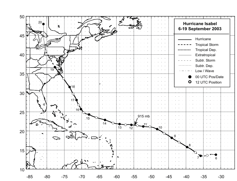
Figure 1:
Best track positions for
Hurricane Isabel, 6-19 September 2003.
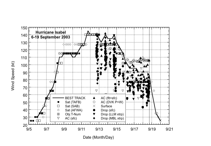
Figure 2:
Selected wind
estimates/observations and best track maximum
sustained surface wind speed curve for Hurricane Isabel, 6-19
September 2003. Aircraft observations have been adjusted for
elevation using 90% and 80% reduction factors for observations from
700 mb and 850 mb respectively. Dropwindsonde observations include
actual 10 m winds (sfc), as well as surface estimates derived from
the mean wind over the lowest 150 m of the wind sounding (LLM), and
from the sounding boundary layer mean (MBL).
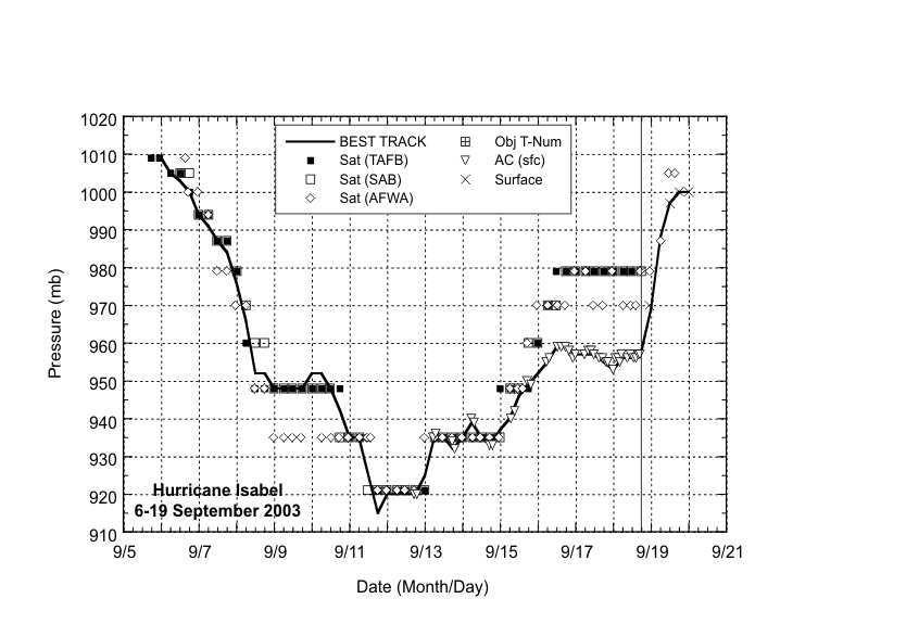
Figure 3:
Selected pressure
estimates/observations and best track minimum
central pressure curve for Hurricane Isabel, 6-19 September
2003.
|


