| NOAA Magazine || NOAA Home Page |
DRY
THUNDERSTORMS MAY SPARK ADDITIONAL WILDFIRES IN THE WEST
NOAA Incident Meteorologists Providing On-Site Support Forecasts
 July
11, 2007 — The combination of record heat, long term drought,
record dry fuels, and an outbreak of thunderstorms producing lightning
but little rainfall, resulted in a rash of new wildfires across the
western and central United States the past few days. These conditions
are expected to continue in the West through the week, according to
forecasters with NOAA’s National
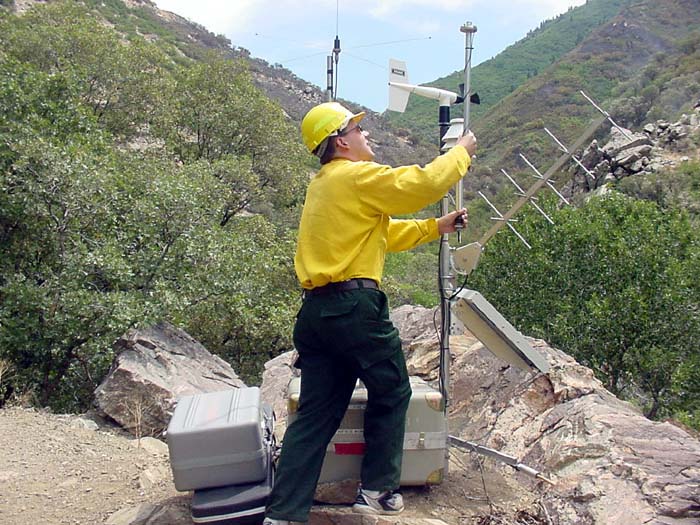
Weather Service. (Click NOAA image for larger view of IMET
Chuck Redman from the NOAA National Weather Service forecast office
in Boise, Idaho, setting up the FireRAWS equipment near a wildfire.
Click here for high resolution
version, which is a large file. Please credit “NOAA.”)
July
11, 2007 — The combination of record heat, long term drought,
record dry fuels, and an outbreak of thunderstorms producing lightning
but little rainfall, resulted in a rash of new wildfires across the
western and central United States the past few days. These conditions
are expected to continue in the West through the week, according to
forecasters with NOAA’s National
Weather Service. (Click NOAA image for larger view of IMET
Chuck Redman from the NOAA National Weather Service forecast office
in Boise, Idaho, setting up the FireRAWS equipment near a wildfire.
Click here for high resolution
version, which is a large file. Please credit “NOAA.”)
“The dry thunderstorms responsible for the current wildfires were well forecasted by the National Weather Service,” said Roger Lamoni, fire weather program manager for the National Weather Service Western Region. “A consistent message of an approaching critical fire weather pattern was delivered to fire agencies days ahead of the event,” Lamoni added.
Once wildfires have started, experienced fire weather forecasters known as Incident Meteorologists (IMETs) are deployed to a fire location to provide tactical support. Currently 17 IMETs are supporting wildfire operations throughout the United States, including one at the Milford Flat fire — the largest fire in Utah’s history.
 Western
U.S. Expects More Dry Thunderstorms
Western
U.S. Expects More Dry Thunderstorms
At
NOAA's Storm Prediction Center
in Norman, Okla., meteorologists are predicting dry thunderstorms to
occur this week in an expanded area from portions of California to Nevada,
Oregon, Idaho, Utah and Arizona. NOAA’s Storm Prediction Center
produces a national fire weather outlook out to eight
days. (Click NOAA image for larger view of NOAA's National
Fire Weather Outlook for Friday, July 13, 2007, which shows critial
fire areas in the West. Please credit “NOAA.”)
“Much of the West is plagued by severe to extreme drought with dry and hot early summer conditions further drying the fuels to record dry levels,” explained Phillip Bothwell, senior development meteorologist at NOAA's Storm Prediction Center. “The early fire weather conditions we’re seeing are more like those we would typically see in August.”
Portions of the Sierra Mountains in southern California had the second lowest snow pack on record. Los Angeles had the driest period in the 130 years of record keeping from July 1, 2006 to June 30, 2007. Hot temperatures and dry conditions are expected over much of the West this week with little relief.
Relief
Possible for Central U.S.
Across the Central U.S, however, forecasts of rain and thunderstorms
bode well for agencies battling wild fires in Colorado, South Dakota
and Wyoming. National Weather Service forecasts include 20 to 30 percent
chances of showers and thunderstorms in some parched areas. Slightly
lower temperatures have helped in the battle against fires that started
last weekend.
“The stifling heat is getting pushed back for a bit,” said
Mike Looney, services chief for the National
Weather Service Central Region. “Higher humidities and any
rain at all would provide relief by putting some moisture in the fuels
in the burning areas. At the same time, lightning from storms that don’t
produce rain could make matters worse by causing more fires.”
Relevant Web Sites
NOAA Fire Weather
Information Center
NOAA National Weather Service Western Region
NOAA National Weather Service Central Region
NOAA National Fire Weather Page
NOAA Provides Critical Support to Wildfire Management
Media
Contact:
Keli
Tarp, NOAA Storm Prediction Center,
(405) 325-6933
Patrick Slattery, National
Weather Service Central Region, (816) 268-3135
Matt Ocaña, National
Weather Service Western Region, (801) 524-5692 x226