| NOAA Magazine || NOAA Home Page |
SMITHSONIAN POSTER EXHIBIT CELEBRATES 200TH ANNIVERSARY OF NOAA PREDECESSOR
 June
21, 2007 � Every day, cruise ships sail from Miami; coal ships deliver
to power plants along the shores of the Great Lakes; crabbing boats
harvest Alaskan king crab in the Bering Sea; and weekenders prepare
their boats for leisurely afternoons on the Chesapeake Bay. Each one
of these mariners uses the resources of NOAA’s
Navigation Services to safely navigate U.S. coastal waters.
(Click NOAA image for a larger view of Image of NOAA ship FAIRWEATHER
and phrase "From Sea to Shining Sea." Please credit “NOAA.”)
June
21, 2007 � Every day, cruise ships sail from Miami; coal ships deliver
to power plants along the shores of the Great Lakes; crabbing boats
harvest Alaskan king crab in the Bering Sea; and weekenders prepare
their boats for leisurely afternoons on the Chesapeake Bay. Each one
of these mariners uses the resources of NOAA’s
Navigation Services to safely navigate U.S. coastal waters.
(Click NOAA image for a larger view of Image of NOAA ship FAIRWEATHER
and phrase "From Sea to Shining Sea." Please credit “NOAA.”)
In recognition of the landmark 200th
anniversary of the establishment of the Survey of the Coast, NOAA
and the Smithsonian Institution Traveling Exhibition Service have created
the exhibit, “From
Sea to Shining Sea: 200 Years of Charting America’s Coasts,”
which opens Thursday, June 21st on World Hydrography Day in over 200
venues nationwide.
The
exhibit includes an education component, including a variety of educational
materials and activities to help teachers, students and parents learn
about our ocean, coasts and skies. These resources cover many aspects
of NOAA’s ocean stewardship, such as deep
sea corals and coral reefs,
ocean
expeditions, and geodesy
— the science of measuring and monitoring the size and shape of
the Earth and the location of points on its surface. The lesson plans,
available at the NOAA
200th Celebration education Web pages, adhere to national science
education standards and the American Association for the Advancement
of Science’s Benchmarks for Science Literacy.
In 1807, President Thomas Jefferson recognized the need to chart the coastal waters of this country as vital to the independence and prosperity of the economy and to the security of this fledgling nation. With his foresight, Jefferson compelled Congress to pass an act establishing the Survey of the Coast, a predecessor agency of today’s NOAA. The Survey of the Coast charted the nation’s ports and waterways, researched physical characteristics of the ocean bottom, and explored many of the world’s oceans. The organization was known for a tradition of perseverance, scientific integrity, engraving and charting skills and courage.
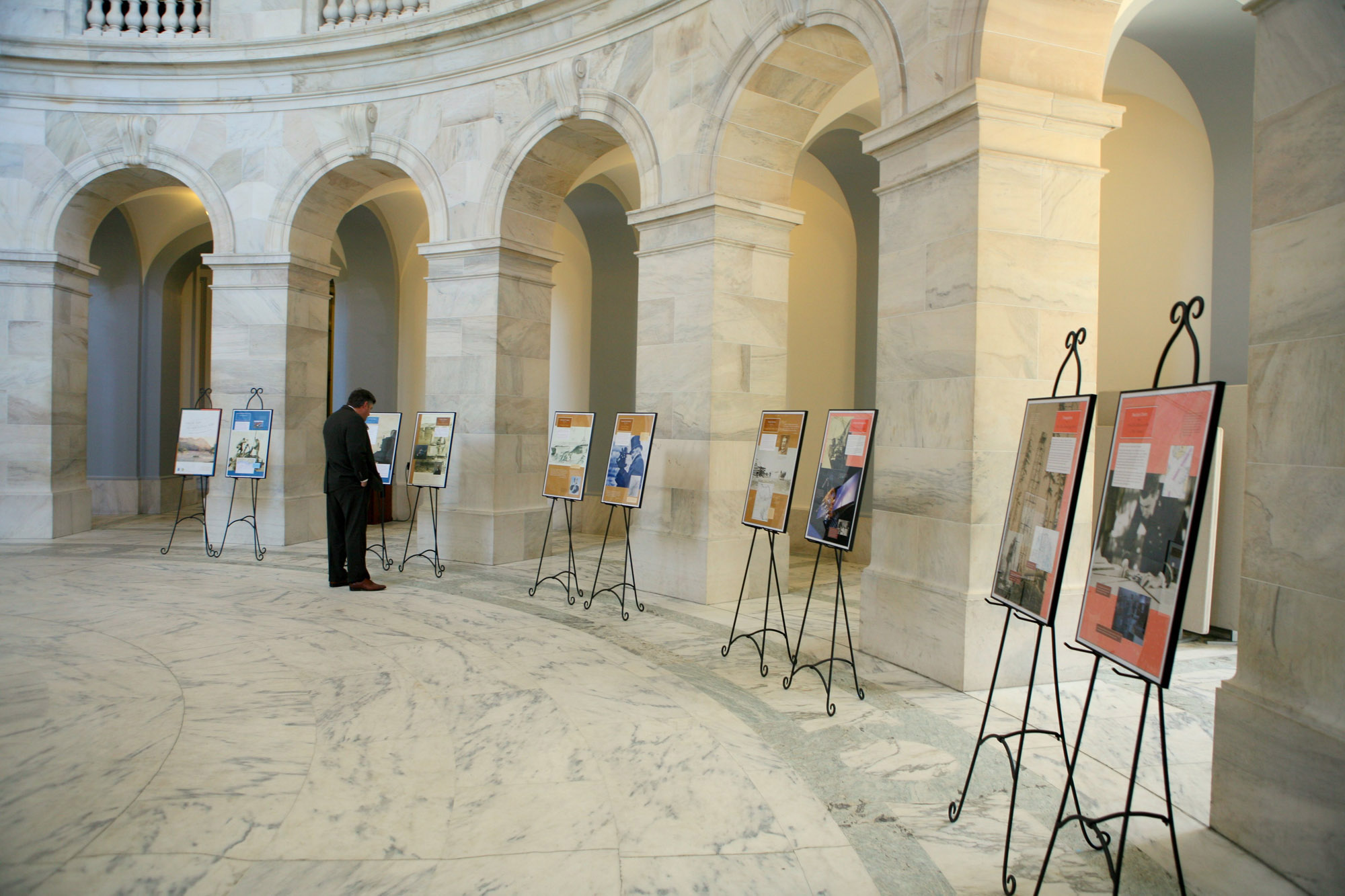
 This
exhibit � which will be shown in maritime museums, ports, aquaria, nature
centers, schools, libraries and lighthouses � celebrates the history,
accomplishments and scientific contributions of the nation’s first
science agency. The 20
colorful posters are illustrated with photos, charts and artwork
from the Survey’s archives. (Click NOAA image for larger
view of the “From Sea to Shining Sea: 200 Years of Charting America’s
Coasts” exhibit, which was displayed in the Russell Senate Office
Building in June 2007. Click here
for high resolution version. Please credit “NOAA.”)
This
exhibit � which will be shown in maritime museums, ports, aquaria, nature
centers, schools, libraries and lighthouses � celebrates the history,
accomplishments and scientific contributions of the nation’s first
science agency. The 20
colorful posters are illustrated with photos, charts and artwork
from the Survey’s archives. (Click NOAA image for larger
view of the “From Sea to Shining Sea: 200 Years of Charting America’s
Coasts” exhibit, which was displayed in the Russell Senate Office
Building in June 2007. Click here
for high resolution version. Please credit “NOAA.”)
“This
year we are proud to be holding a year-long celebration of 200 years
of science, service, and stewardship to the nation originating with
the Survey of the Coast,” said Captain Steven
R. Barnum, director of NOAA's
Office of Coast Survey, which is one of the four offices that continues
to carry out the original agency's mission. “We are honored that
our partnership with the Smithsonian Institution has produced this vibrant
depiction of our history to help us commemorate this distinguished occasion.”
Today, waterborne commerce remains the backbone of the U.S. economy,
contributing approximately 13 million jobs and $1 trillion annually.
In the past two centuries, the Survey has mapped more than 95,000 miles
of coastline, produced more than 20,000 nautical
maps and charts, installed more than 6,000 tide
stations, helped predict the movement of oil spills, established the
Pacific Tsunami Warning System
and maintained the national network of more than 1,000 GPS
reference sites. Though the methods have changed throughout time, Jefferson’s
legacy lives on in NOAA’s navigation services as they continue
to benefit safety, national security and economic competitiveness.
In 2007 NOAA, an agency of the U.S. Commerce Department, celebrates
200 years of science
and service to the nation. From the establishment of the Survey
of the Coast in 1807 by Thomas Jefferson to the formation of the Weather
Bureau and the Bureau of Commercial Fisheries in the 1870’s, much
of America's scientific heritage is rooted in NOAA.
An agency of the U.S. Commerce Department,
NOAA is dedicated to enhancing economic security and national safety
through the prediction and research of weather and climate-related events
and information service delivery for transportation, and by providing
environmental stewardship of our nation's coastal and marine resources.
Through the emerging Global Earth Observation System of Systems (GEOSS),
NOAA is working with its federal partners, more than 60 countries and
the European Commission to develop a global monitoring network that
is as integrated as the planet it observes, predicts and protects.
SITES has been sharing the wealth of Smithsonian collections and research
programs with millions of people outside Washington, D.C., for more
than 50 years. SITES connects Americans to their shared cultural heritage
through a wide range of exhibitions about art, science and history,
which are shown wherever people live, work and play.
Relevant Web Sites
NOAA
NOAA 200th
SITES exhibition and schedules
SITES host venues
Media
Contact:
Ben Sherman, NOAA
Ocean Service, (301) 713-3066