|
|
Defense Meteorological Satellite Program
|
Since the mid-1960's, when the Department of Defense (DOD) initiated the
Defense Meteorological Satellite Program (DMSP), low, earth-orbiting satellites
have provided the military with important environmental information.
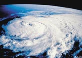
The DMSP satellites "see" such environmental features as clouds, bodies of
water, snow, fire, and pollution in the visual and infrared spectra. Scanning
radiometers record information which can help determine cloud type and height,
land and surface water temperatures, water currents, ocean surface features,
ice, and snow. Communicated to ground-based terminals, the data is processed,
interpreted by meteorologists, and ultimately used in planning and conducting
U.S. military operations worldwide.
http://dmsp.ngdc.noaa.gov/dmsp.html
(Note: link with a # beside it will lead you
out of the Federal Government webspace)
Home | Operations |
News | Daily Updates |
Info & History
GOES | POES |
DMSP | Contact Us |
Internal
Webmaster
Privacy Policy
|
|
 |