www.weather.gov
Site Map
News
Organization
Search
Search by city or zip code. Press enter or select the go button to submit request
Local forecast by
"City, St"
Search HPC
Analyses and Forecasts
HPC Discussions
Surface Analysis
Short Range
Days 3 - 7
QPF
Excessive
Rainfall
Flood Outlook
Winter Weather
Storm
Summaries
Heat Index
Air Quality
Alaska Days 4-8
Tropical
Products
Selected Cities
Daily Weather
Map
Current Watches/
Warnings
Satellite and Radar Imagery
Satellite Images
National Radar
Verification
HPC Verification
NPVU
Model
Diagnostics
International Desks
Development and Training
Development
Experimental
Products
HPC Overview
About the HPC
Mission and
Vision
HPC History
About Our
Products
Accomplishments
Other Sites
FAQs
Meteorological Calculators
Contact Us
About Our Site
About Our
Products
Medium Range Forecasts
(Days 3-7)
Sea Level Pressures and Fronts
Preliminary Graphics
Final Graphics
Maximum Temperatures
Minimum Temperatures
Precipitation Probabilities
12-hour forecasts
24-hour forecasts
Max/Min/Precip Probability Composites
HPC's Day 4-7 Gridded Forecasts
Day 3-7 Temperature and PoP Forecasts - Text Format
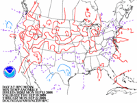
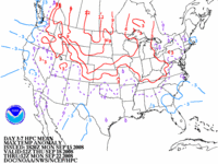
HPC's 5-Day Total QPF/5-Day Mean Temperatures
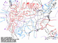
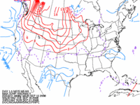
HPC's Day 3-7 500mb Height Forecasts for the Continental U.S.
GFS 500mb Height/Anomaly Forecasts
Interactive Medium Range Products Browser
Hawaiian Discussion
Day 1-5 Total QPF
5-Day Mean Temperature Forecasts
Day 1-5 Minimum
Temperature Anomaly
(from MOS)
Day 1-5 Maximum
Temperature Anomaly
(from MOS)
Day 3-7 Minimum
Temperature Anomaly
(from HPC)
Day 3-7 Maximum
Temperature Anomaly
(from HPC)
FORECAST DISCUSSION:
NFDPMDEPD (FXUS02 KWBC)
About These Products
NOAA/
National Weather Service
National Centers for Environmental Prediction
Hydrometeorological Prediction Center
5200 Auth Rd
Camp Springs, Maryland 20746
Hydrometeorological Prediction Center Web Team
Disclaimer
Credits
Glossary
Privacy Policy
About Us
Career Opportunities
Page last modified: Tuesday, 29-Jan-2008 16:25:04 GMT