
 Feeds & Data
Magnitude 4.1 - BONIN ISLANDS, JAPAN REGION
2008 September 14 04:09:49 UTC
Earthquake Details
| Magnitude | 4.1 |
|---|---|
| Date-Time |
|
| Location | 28.390°N, 139.612°E |
| Depth | 447.8 km (278.3 miles) |
| Region | BONIN ISLANDS, JAPAN REGION |
| Distances | 295 km (185 miles) WNW of Chichi-shima, Bonin Islands, Japan 435 km (270 miles) NNW of Iwo-jima, Volcano Islands, Japan 520 km (325 miles) S of Hachijo-jima, Izu Islands, Japan 810 km (500 miles) S of TOKYO, Japan |
| Location Uncertainty | horizontal +/- 12.5 km (7.8 miles); depth +/- 12.7 km (7.9 miles) |
| Parameters | NST= 51, Nph= 51, Dmin=914.6 km, Rmss=0.65 sec, Gp=119°, M-type=body magnitude (Mb), Version=Q |
| Source |
|
| Event ID | us2008wyaj |
- This event has been reviewed by a seismologist.
- Did you feel it? Report shaking and damage at your location. You can also view a map displaying accumulated data from your report and others.
Earthquake Maps

Earthquake Location
Location Maps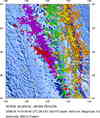
Historical Seismicity
Seismic Hazard Map
EQ Density Map
Google Map
Google Earth KML
(Requires Google Earth)- Did you feel it? Report shaking and damage at your location. You can also view a map displaying accumulated data from your report and others.
Scientific & Technical Information
 Historic Moment Tensor Solutions
- Preliminary Earthquake Report
- U.S. Geological Survey, National Earthquake Information Center:
World Data Center for Seismology, Denver
