Shapefile Datum Conversion Tool
Product Description
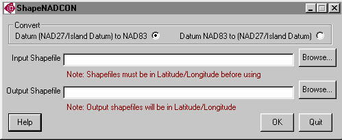 ShapeNADCON, or the Shapefile Datum Conversion Tool, is both a stand-alone program and an extension for ArcView� 3.x that quickly converts Environmental Systems Research Institute (ESRI�) shapefiles from one standard datum to another. Specifically, the software transforms the North American Datum of 1927 (NAD27) or a designated island datum to the North American Datum of 1983 (NAD83)-or, conversely, it will convert NAD83 to NAD27 or an island datum. An island datum refers to the unique datum defined for each of the island groups of Guam, American Samoa, and the Commonwealth of the Northern Mariana Islands (CNMI).
As indicated by its name, ShapeNADCON uses the latest North American Datum Conversion (NADCON) grids and interpolation methods from the National Oceanic and Atmospheric Administration's (NOAA) National Geodetic Survey. These latest grids and parameters expand the coverage of previous versions of NADCON to include Guam, American Samoa, and CNMI.
Please note:
- Shapefiles to be converted must be in latitude/longitude.
- CNMI datum transformation is performed using a 3-parameter Molodensky transformation rather the more accurate NADCON grid transformation because transformation grids have not yet been developed for CNMI.
Download ShapeNADCON
ShapeNADCON stand-alone program for Microsoft� Windows� only (3.2 megabytes).
ShapeNADCON stand-alone program and ArcView 3.x extension for Windows (3.2 megabytes).
ShapeNADCON was initially developed by the NOAA Coastal Services Center in partnership with the National Geodetic Survey to support a geodetic reference and spatial data infrastructure modernization project.