Skip Navigation Links www.weather.gov 
NOAA logo - Click to go to the NOAA homepage National Weather Service   NWS logo - Click to go to the NWS homepage
The Hydrometeorological Prediction Center


Medium Range Forecasts
(Days 3-7)


Sea Level Pressures and Fronts
Preliminary Graphics                   Final Graphics
Maximum Temperatures
Minimum Temperatures
Precipitation Probabilities
12-hour forecasts                     24-hour forecasts
Max/Min/Precip Probability Composites
HPC's Day 4-7 Gridded Forecasts
Day 3-7 Temperature and PoP Forecasts - Text Format
HPC's 5-Day Total QPF/5-Day Mean Temperature Forecasts
HPC's Day 3-7 500mb Height Forecasts for the Continental U.S.
GFS 500mb Height/Anomaly Forecasts
Interactive Medium Range Products Browser
Hawaiian Discussion


Preliminary Sea Level Pressures and Fronts
(available by 1315 UTC)

Note: These are unofficial products intended for coordination purposes only. Significant modifications are possible for the final issuance at 1900 UTC.

Day 3 Fronts and Pressures
Day 3
[b/w]   [full color]
Day 4 Fronts and Pressures
Day 4
[b/w]   [full color]
Day 5 Fronts and Pressures
Day 5
[b/w]   [full color]
Day 6 Fronts and Pressures
Day 6
[b/w]   [full color]
Day 7 Fronts and Pressures
Day 7
[b/w]   [full color]
Day 3-7 Fronts and Pressures for the U.S.
Days 3-7
[b/w]

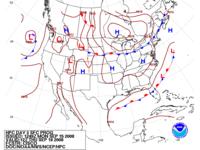
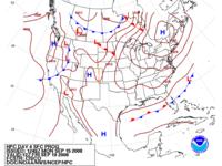
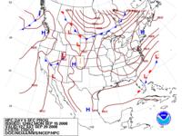
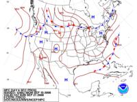
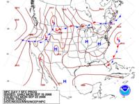
Loop of sea-level pressures and fronts through day 7

[new]" Preliminary Forecast Discussion
(NFDPREEPD)


About These Products


NOAA/ National Weather Service
National Centers for Environmental Prediction
Hydrometeorological Prediction Center
5200 Auth Rd
Camp Springs, Maryland 20746
Hydrometeorological Prediction Center Web Team
Disclaimer
Credits
Glossary
Privacy Policy
About Us
Career Opportunities
Page last modified: Tuesday, 29-Jan-2008 14:32:34 GMT