Top 10 Weather Headlines of 2004
-
The 2004 spring severe weather season got off to a slow start, with few severe storms until the last week of May. A series of severe storm outbreaks during the last week of May and June 1 produced widespread wind damage. Southwest Indiana, southern Illinois, and the Henderson/Owensboro areas were struck several times by widespread damaging winds and isolated tornadoes. Unlike 2002 and 2003, there were no tornadoes ranked stronger than F-2 in 2004.
-
The winter season of 2003-04 was relatively quiet. An ice storm in southwest Indiana, southern Illinois, and northwest Kentucky occurred on January 25. One of the latest snows on record covered dogwoods and redbud trees in parts of western Kentucky on April 13.
The following events are ranked subjectively based on their overall social impact. News media reports are used to help determine the social impact. Monetary damage estimates are taken into account, along with reports of injuries or fatalities.
 1.
May
30 Severe Storms and Tornadoes - An outbreak of isolated
supercell storms and tornadoes occurred during the midday hours, followed
by a widespread damaging wind event during the evening. All combined, over
5 million dollars in damage occurred. Dozens of homes were damaged. Ten
tornadoes were confirmed, including two that reached F-2 intensity. One
F-2 tornado caused major damage in Newburgh, IN. Damaging winds occurred
in 56 counties in southern Illinois, southwest Indiana, southeast
Missouri, and western Kentucky. No injuries were reported. 1.
May
30 Severe Storms and Tornadoes - An outbreak of isolated
supercell storms and tornadoes occurred during the midday hours, followed
by a widespread damaging wind event during the evening. All combined, over
5 million dollars in damage occurred. Dozens of homes were damaged. Ten
tornadoes were confirmed, including two that reached F-2 intensity. One
F-2 tornado caused major damage in Newburgh, IN. Damaging winds occurred
in 56 counties in southern Illinois, southwest Indiana, southeast
Missouri, and western Kentucky. No injuries were reported. |
 2.
.May
27 Damaging Winds - A line of severe thunderstorms crossed
southern Illinois, southwest Indiana, and northwest Kentucky during the
evening. Widespread extremely damaging winds in excess of 80 MPH caused at
least 3 million dollars in damage. In southern Illinois, two persons were
injured when their camper was overturned. One person was killed and
numerous others injured in vehicle collisions with fallen trees. In
Daviess County, KY, winds up to 120 MPH damaged or destroyed over a
hundred homes. The governor of Kentucky visited the area. 2.
.May
27 Damaging Winds - A line of severe thunderstorms crossed
southern Illinois, southwest Indiana, and northwest Kentucky during the
evening. Widespread extremely damaging winds in excess of 80 MPH caused at
least 3 million dollars in damage. In southern Illinois, two persons were
injured when their camper was overturned. One person was killed and
numerous others injured in vehicle collisions with fallen trees. In
Daviess County, KY, winds up to 120 MPH damaged or destroyed over a
hundred homes. The governor of Kentucky visited the area. |
 3.
Dec. 22
Winter Storm - Record snowfall amounts up to two feet paralyzed
much of the region. Drifts were measured as deep as 60 inches. The
National Guard was mobilized to aid motorists stranded on Interstates 24
and 64. Several structures collapsed under the weight of the snow and ice.
The timing of the snow provided most of southwest Kentucky with its first
White Christmas since 1990. In addition to breaking 24-hour snowfall
records, the storm gave Paducah its snowiest December on record. The snow
was followed by record cold. (Photo by Charlie Kiesel). 3.
Dec. 22
Winter Storm - Record snowfall amounts up to two feet paralyzed
much of the region. Drifts were measured as deep as 60 inches. The
National Guard was mobilized to aid motorists stranded on Interstates 24
and 64. Several structures collapsed under the weight of the snow and ice.
The timing of the snow provided most of southwest Kentucky with its first
White Christmas since 1990. In addition to breaking 24-hour snowfall
records, the storm gave Paducah its snowiest December on record. The snow
was followed by record cold. (Photo by Charlie Kiesel). |
 4.
October 18 Tornadoes in Southern IL - A supercell thunderstorm
tracked east across southern IL, producing two F-2 tornadoes with a
combined path length of 23 miles. The heaviest damage and two injuries
occurred about 10 miles south of Marion, near the Lake of Egypt. Mobile
homes were demolished. A trucker was injured when his rig was overturned
near the junction of Interstates 57 and 24. Much of the path length was
through the Shawnee National Forest. Other supercell storms occurred
across the region, producing large hail. 4.
October 18 Tornadoes in Southern IL - A supercell thunderstorm
tracked east across southern IL, producing two F-2 tornadoes with a
combined path length of 23 miles. The heaviest damage and two injuries
occurred about 10 miles south of Marion, near the Lake of Egypt. Mobile
homes were demolished. A trucker was injured when his rig was overturned
near the junction of Interstates 57 and 24. Much of the path length was
through the Shawnee National Forest. Other supercell storms occurred
across the region, producing large hail. |
 5.
July 16 Flash Flood in Evansville - About 180 residences were
damaged or affected by flash flooding that occurred during the night.
Severe flash flooding of Locust Creek inundated a manufactured and mobile
home park near McCutchanville. Over 150 vehicles were submerged to a depth
of at least four feet, and 26 residences were evacuated by boat. Downtown
Evansville reported an unofficial rainfall of 4.88 inches. Damage was
estimated at nearly a million dollars. Image at left is a radar-estimated
rainfall graphic. 5.
July 16 Flash Flood in Evansville - About 180 residences were
damaged or affected by flash flooding that occurred during the night.
Severe flash flooding of Locust Creek inundated a manufactured and mobile
home park near McCutchanville. Over 150 vehicles were submerged to a depth
of at least four feet, and 26 residences were evacuated by boat. Downtown
Evansville reported an unofficial rainfall of 4.88 inches. Damage was
estimated at nearly a million dollars. Image at left is a radar-estimated
rainfall graphic. |
 6.
April
24 Tornadoes in SE Missouri - Three tornadoes were confirmed
in Carter, Wayne, and Cape Girardeau Counties. Five persons were injured
by the F-2 tornado at Ellsinore in Carter County. An occupant of a
demolished mobile home was seriously injured. The other two tornadoes
produced roof and tree damage, but no injuries. All three tornado path
lengths were 4 to 8 miles. 6.
April
24 Tornadoes in SE Missouri - Three tornadoes were confirmed
in Carter, Wayne, and Cape Girardeau Counties. Five persons were injured
by the F-2 tornado at Ellsinore in Carter County. An occupant of a
demolished mobile home was seriously injured. The other two tornadoes
produced roof and tree damage, but no injuries. All three tornado path
lengths were 4 to 8 miles. |
 7.
July 5 Wind
Damage in Evansville Tri-State Area - A swath of widespread
wind damage began near Carmi, IL around noon and extended southeast to
Henderson and Owensboro, KY. Tens of thousands of utility customers were
still without power early the next morning. Dozens of houses were damaged.
A wind gust was measured to 63 MPH at the Owensboro Airport. 7.
July 5 Wind
Damage in Evansville Tri-State Area - A swath of widespread
wind damage began near Carmi, IL around noon and extended southeast to
Henderson and Owensboro, KY. Tens of thousands of utility customers were
still without power early the next morning. Dozens of houses were damaged.
A wind gust was measured to 63 MPH at the Owensboro Airport. |
 8.
July
13 Wind Damage - For the fourth time since late May,
northwest Kentucky was raked by widespread damaging winds. This complex of
storms moved due south across southwest Indiana and the Pennyrile Region
of western KY. 8.
July
13 Wind Damage - For the fourth time since late May,
northwest Kentucky was raked by widespread damaging winds. This complex of
storms moved due south across southwest Indiana and the Pennyrile Region
of western KY. |
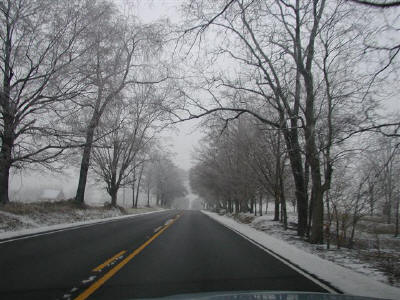 9.
January
25 Ice Storm - About a half inch of ice coated southwest IN,
much of southern IL, and the Henderson and Owensboro areas. Some roads
were closed and/or nearly impassable. Tree limbs were downed, causing
scattered power outages. (Photo courtesy of Norm Bredenkamp). 9.
January
25 Ice Storm - About a half inch of ice coated southwest IN,
much of southern IL, and the Henderson and Owensboro areas. Some roads
were closed and/or nearly impassable. Tree limbs were downed, causing
scattered power outages. (Photo courtesy of Norm Bredenkamp). |
 10.
Snowstorm
on February 5 - Three to five inches of snow blanketed most
of southern Illinois and southeast Missouri. The snow fell at a rapid rate
just before sunrise, causing a messy morning commute. Most schools were
closed. 10.
Snowstorm
on February 5 - Three to five inches of snow blanketed most
of southern Illinois and southeast Missouri. The snow fell at a rapid rate
just before sunrise, causing a messy morning commute. Most schools were
closed. |
|
Have a safe and happy 2005! |