Top 10 Weather Headlines of 2005
-
On both a national and a local scale, extreme weather events in 2005 captured our attention. A record-breaking hurricane season dominated the weather news for months. The remnants of tropical systems brought the majority of our summer rainfall, averting a potentially disastrous agricultural drought. The remnants of Katrina were indirectly responsible for flooding that claimed a life in western Kentucky.
- The unusually quiet spring severe weather season passed without a single significant (F-2 or stronger) tornado. Then in November, three tornado outbreaks made 2005 the deadliest in many years in our region. Of the approximately two dozen fatalities, most were at a mobile home park near Evansville, Indiana.
The following weather events are ranked unscientifically. The primary ranking factors are the extent of news media coverage, number of fatalities and injuries, and economic impact. The meteorological significance of the event is secondary.
 1. Nov. 6 Evansville Area Tornado - This F-3 tornado tracked 41 miles from northwest Henderson County, KY to Spencer County, IN. About two dozen persons lost their lives, most at a mobile home park near the southern city limit of Evansville. Over 200 persons were injured. The tornado struck around 2 A.M., catching many of its victims asleep. Over 100 homes and buildings were destroyed. At the same time, another F-3 tornado occurred in Crittenden and Webster Counties of KY, injuring several people. (Photo courtesy of Deaconess Women's Hospital in Evansville). 1. Nov. 6 Evansville Area Tornado - This F-3 tornado tracked 41 miles from northwest Henderson County, KY to Spencer County, IN. About two dozen persons lost their lives, most at a mobile home park near the southern city limit of Evansville. Over 200 persons were injured. The tornado struck around 2 A.M., catching many of its victims asleep. Over 100 homes and buildings were destroyed. At the same time, another F-3 tornado occurred in Crittenden and Webster Counties of KY, injuring several people. (Photo courtesy of Deaconess Women's Hospital in Evansville). |
 2 . Nov. 15 Tornadoes - Western Kentucky bore the brunt of this tornado outbreak, which followed close on the heels of the Evansville area disaster. A violent F-4 tornado tracked across Hopkins County, levelling over 100 homes and injuring 27 people. In far west Kentucky, an F-3 tornado tracked 44 miles from Graves County across the Land-Between-The-Lakes Region. This tornado killed one person in a Marshall County mobile home. Eleven other tornadoes were confirmed, all of which were rated F-0 or F-1. (Photo of Hopkins Co. tornado taken by Leonard Costanzo). 2 . Nov. 15 Tornadoes - Western Kentucky bore the brunt of this tornado outbreak, which followed close on the heels of the Evansville area disaster. A violent F-4 tornado tracked across Hopkins County, levelling over 100 homes and injuring 27 people. In far west Kentucky, an F-3 tornado tracked 44 miles from Graves County across the Land-Between-The-Lakes Region. This tornado killed one person in a Marshall County mobile home. Eleven other tornadoes were confirmed, all of which were rated F-0 or F-1. (Photo of Hopkins Co. tornado taken by Leonard Costanzo). |
.gif) 3. Flash Flooding on night of Nov. 14 - Major flash flooding occurred from Wayne County, MO eastward across Marion, IL to Henderson, KY. Damage in Henderson County alone was estimated near 17.5 million dollars. Major flash flooding of creeks was reported in Wayne and Bollinger Counties of Missouri. A school bus was swept off a road by floodwaters near Marion, IL. The heavy rainfall, measured around 8 inches in spots, preceded a major tornado outbreak the following afternoon. (Radar-generated map of estimated rainfall amounts; click for full size). 3. Flash Flooding on night of Nov. 14 - Major flash flooding occurred from Wayne County, MO eastward across Marion, IL to Henderson, KY. Damage in Henderson County alone was estimated near 17.5 million dollars. Major flash flooding of creeks was reported in Wayne and Bollinger Counties of Missouri. A school bus was swept off a road by floodwaters near Marion, IL. The heavy rainfall, measured around 8 inches in spots, preceded a major tornado outbreak the following afternoon. (Radar-generated map of estimated rainfall amounts; click for full size). |
 4. Wabash and Ohio River Flooding in January - Major flooding of the Lower Wabash River and its tributaries, as well as the Lower Ohio River, resulted from heavy rain and rapid snowmelt following the Dec. 22 winter storm. A new record flood crest was recorded at the Mount Carmel, IL gage on the Wabash River. On the White River, a levee protecting the town of Hazleton was on the verge of failure, requiring evacuation of the town. A railroad bridge over the Wabash River collapsed into the river. (Photo of State Route 64 bridge at East Mount Carmel, IN). 4. Wabash and Ohio River Flooding in January - Major flooding of the Lower Wabash River and its tributaries, as well as the Lower Ohio River, resulted from heavy rain and rapid snowmelt following the Dec. 22 winter storm. A new record flood crest was recorded at the Mount Carmel, IL gage on the Wabash River. On the White River, a levee protecting the town of Hazleton was on the verge of failure, requiring evacuation of the town. A railroad bridge over the Wabash River collapsed into the river. (Photo of State Route 64 bridge at East Mount Carmel, IN). |
 5. Late July Heat Wave - Two fatalities and over 200 cases of heat-related illness occurred. During the period from July 21-26, heat indices reached at least 110 degrees each afternoon over parts of the region. Dew points were at or above 80 degrees in some places each afternoon. Record maximum lows in the upper 70's were set at Paducah and Cape Girardeau. The two deaths were in Cape Girardeau, Missouri. (Graphic of peak heat indices; click for full size). 5. Late July Heat Wave - Two fatalities and over 200 cases of heat-related illness occurred. During the period from July 21-26, heat indices reached at least 110 degrees each afternoon over parts of the region. Dew points were at or above 80 degrees in some places each afternoon. Record maximum lows in the upper 70's were set at Paducah and Cape Girardeau. The two deaths were in Cape Girardeau, Missouri. (Graphic of peak heat indices; click for full size). |
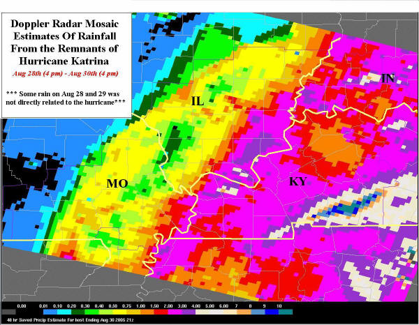 6. Remnants of Hurricane Katrina - Up to 10 inches of rain fell in the Hopkinsville, KY area, producing major flooding there. One fatality occurred in Hopkinsville. 142 residences and 38 businesses were affected by the flooding, resulting in about 5 million dollars in damage. The areal extent of flooding in Christian County was comparable to the 1997 flood there. Numerous tree limbs were blown down by wind gusts to near 50 MPH. Over 10,000 utility customers lost power in western KY. (Graphic of radar-estimated rainfall amounts; click for full size). 6. Remnants of Hurricane Katrina - Up to 10 inches of rain fell in the Hopkinsville, KY area, producing major flooding there. One fatality occurred in Hopkinsville. 142 residences and 38 businesses were affected by the flooding, resulting in about 5 million dollars in damage. The areal extent of flooding in Christian County was comparable to the 1997 flood there. Numerous tree limbs were blown down by wind gusts to near 50 MPH. Over 10,000 utility customers lost power in western KY. (Graphic of radar-estimated rainfall amounts; click for full size). |
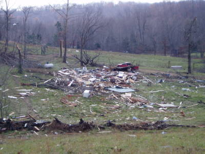 7. Deadly Tornado in Ripley County, MO - The last of three deadly November tornadoes struck the Ozarks of southern Missouri on the late evening of Nov. 27. The F-2 tornado destroyed a two-story home, taking the life of an elderly man on the second floor. Two other people on the first floor were not injured. (Photo of destroyed residence). 7. Deadly Tornado in Ripley County, MO - The last of three deadly November tornadoes struck the Ozarks of southern Missouri on the late evening of Nov. 27. The F-2 tornado destroyed a two-story home, taking the life of an elderly man on the second floor. Two other people on the first floor were not injured. (Photo of destroyed residence). |
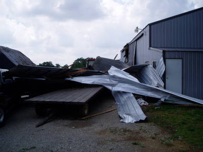 8. May 19 Severe Storms - The Paducah office issued 52 Severe Thunderstorm Warnings and 3 Tornado Warnings during this prolonged severe weather outbreak. A couple of F-1 tornadoes occurred in Christian and Todd Counties in western KY. Baseball size hail fell near the Hopkins/Caldwell County KY line. (Photo of tornado damage near Christian/Todd Co. line). 8. May 19 Severe Storms - The Paducah office issued 52 Severe Thunderstorm Warnings and 3 Tornado Warnings during this prolonged severe weather outbreak. A couple of F-1 tornadoes occurred in Christian and Todd Counties in western KY. Baseball size hail fell near the Hopkins/Caldwell County KY line. (Photo of tornado damage near Christian/Todd Co. line). |
 9. April 12 Severe Storms and Tornado - Copious amounts of hail fell in severe storms, mainly across southern Illinois and southeast Missouri. The ground was covered with hail in some places. A persistent funnel cloud over Cape Girardeau County received widespread media attention. A weak tornado touched down near Rend Lake, Illinois at the end of the outbreak. (Photo of funnel cloud near Jackson, MO from Nick Palisch). 9. April 12 Severe Storms and Tornado - Copious amounts of hail fell in severe storms, mainly across southern Illinois and southeast Missouri. The ground was covered with hail in some places. A persistent funnel cloud over Cape Girardeau County received widespread media attention. A weak tornado touched down near Rend Lake, Illinois at the end of the outbreak. (Photo of funnel cloud near Jackson, MO from Nick Palisch). |
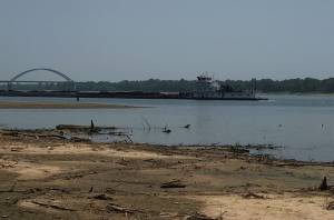 10. Summer Drought / Low water - River levels on the Mississippi and Ohio Rivers reached critically low thresholds in August. The Coast Guard closed the Ohio River to all commercial river traffic on a 7-mile stretch just above Cairo, Illinois. Restrictions were placed in effect for traffic on the Mississippi. Deliveries of fuel and other commodities were commonly delayed or cancelled. (Photo of a barge passing sandbars in the Ohio River near Paducah, KY and the Interstate 24 bridge). 10. Summer Drought / Low water - River levels on the Mississippi and Ohio Rivers reached critically low thresholds in August. The Coast Guard closed the Ohio River to all commercial river traffic on a 7-mile stretch just above Cairo, Illinois. Restrictions were placed in effect for traffic on the Mississippi. Deliveries of fuel and other commodities were commonly delayed or cancelled. (Photo of a barge passing sandbars in the Ohio River near Paducah, KY and the Interstate 24 bridge). |
|
Have a safe and happy 2006! |