Overview of January 8 storms
- The Storm Prediction Center issued Tornado Watch Number 8 during the morning of January 8 for parts of west Kentucky and southeast Missouri.
- The potential of severe weather increased during the early afternoon as strong southerly winds brought slightly greater instability. See Mesoscale Discussion 32 from the Storm Prediction Center.
- During the early afternoon, Tornado Watch Number 9 was issued for western Kentucky, southwest Indiana, and a small part of southeast Illinois.
- Shortly before the issuance of the second tornado watch, outbuildings were destroyed and two houses were moderately damaged in Stoddard County, Missouri. A National Weather Service damage survey team completed a survey of this damage and determined an EF-1 tornado occurred.
- Around 4:15 P.M., a funnel cloud and golf-ball size hail was observed in Evansville, Indiana. Power poles were snapped off near Evansville. The National Weather Service determined this damage was not tornadic.
- Locally heavy rain occurred in some areas, especially southeast Illinois and parts of southwest Indiana. A total of 1.5 inches of rain was reported in one hour at Harrisburg, Illinois. Water was reported over roads in Gallatin County, IL and Posey County, IN among others.
Preliminary Storm Reports for Jan. 8
PRELIMINARY LOCAL STORM REPORT...SUMMARY
NATIONAL WEATHER SERVICE
829 PM CST TUE JAN 08 2008
..TIME... ...EVENT... ...CITY LOCATION... ...LAT.LON...
..DATE... ....MAG.... ..COUNTY LOCATION..ST.. ...SOURCE....
..REMARKS..
1250 PM TORNADO 2 NE ESSEX 36.83N 89.84W
01/08/2008 STODDARD MO EMERGENCY MNGR
OUTBUILDINGS BLOWN AWAY AND POWER LINES BLOWN DOWN.
0141 PM HEAVY RAIN E HARRISBURG 37.74N 88.55W
01/08/2008 E1.50 INCH SALINE IL TRAINED SPOTTER
THIS RAINFALL FELL IN A ONE HOUR TIME PERIOD
0310 PM FUNNEL CLOUD 1 S CLINTON 36.65N 88.99W
01/08/2008 HICKMAN KY LAW ENFORCEMENT
FUNNEL CLOUD WAS ROTATING AT TIME THAT IT WAS OBSERVED.
0314 PM FLOOD POPLAR BLUFF 36.76N 90.41W
01/08/2008 BUTLER MO BROADCAST MEDIA
STREET FLOODING IN POPLAR BLUFF. ALSO, THE BLACK RIVER AT
HWY 142 WAS OUT OF ITS BANKS SOUTH OF POPLAR BLUFF.
0340 PM FLOOD SHAWNEETOWN 37.71N 88.17W
01/08/2008 GALLATIN IL EMERGENCY MNGR
STANDING WATER ON MAJOR HIGHWAYS AND NUMEROUS SECONDARY
ROADS THROUGHOUT GALLATIN COUNTY.
0404 PM TSTM WND GST GRAND RIVERS 37.01N 88.24W
01/08/2008 E60.00 MPH LIVINGSTON KY LAW ENFORCEMENT
ALSO, 0.25 INCH DIAMETER HAIL REPORTED AT THE
INTERSECTION OF I-24 AND KY HWY 453
0416 PM HAIL EVANSVILLE 37.98N 87.54W
01/08/2008 E1.75 INCH VANDERBURGH IN BROADCAST MEDIA
REPORTED AT THE UNIVERSITY OF SOUTHERN INDIANA WHICH IS
ON THE WEST SIDE OF THE CITY OF EVANSVILLE.
0417 PM FUNNEL CLOUD EVANSVILLE 37.98N 87.54W
01/08/2008 VANDERBURGH IN EMERGENCY MNGR
REPORTED ALOFT OVER CENTRAL HIGH SCHOOL IN THE NORTHERN
PART OF THE CITY OF EVANSVILLE.
0420 PM TSTM WND DMG 1 W INGLEFIELD 38.11N 87.58W
01/08/2008 VANDERBURGH IN TRAINED SPOTTER
NUMEROUS POWER POLES SNAPPED OFF AT GROUND LEVEL IN A ONE
QUARTER TO ONE HALF MILE PATH OF DAMAGE.
0427 PM FLOOD EVANSVILLE 37.98N 87.54W
01/08/2008 VANDERBURGH IN TRAINED SPOTTER
WATER OVER LYNCH ROAD,BETWEEN HWY 41 AND OAK HILL ROAD.
THE ROAD IS IMPASSIBLE.
0536 PM FUNNEL CLOUD WEST LOUISVILLE 37.70N 87.29W
01/08/2008 DAVIESS KY EMERGENCY MNGR
THIS FUNNEL CLOUD WAS ROTATING AT THE TIME OF THE REPORT
AND WAS LOCATED JUST TO THE EAST OF WEST LOUISVILLE.
Radar image of a line of thunderstorms crossing northwest Graves and southwest McCracken Counties at 3:21 P.M. on January 8. Rotation was occurring near the break in the line over west central Graves County. The location of the actual Paducah radar site is the small black hole near the top of the image.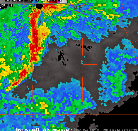
Record Warmth and January Tornado Climatology
- Record warmth was recorded on Monday, Jan. 7. The high temperature at Paducah was 70 degrees, breaking the old record of 68 degrees set in 1965. The warmest temperature recorded in the entire month of January is 77 degrees at Paducah. This monthly record was set on Jan. 25, 1943.
- A record high was established at Evansville on Monday, Jan. 7. The high temperature was 68 degrees, breaking the old record of 67 degrees set in 1989.
- The record warmth was a contributing factor for severe weather potential. Tornado climatology in our part of the country shows that tornadoes have occurred in January. Most recently, an F-3 tornado struck the city of Owensboro, KY on Jan. 3, 2000. Two major severe weather outbreaks occurred in mid-Janaury of 1999.
- On January 7, 1989, an F-4 tornado struck Wabash County, IL. This is the strongest January tornado in official records in the Paducah National Weather Service county warning area. These records go back to 1950.
- Going back to unofficial records prior to 1950, a tornado outbreak occurred on January 12, 1890 in the Mississippi River counties of western Kentucky and southeast Missouri. One of the tornadoes was suspected of causing F-4 damage.
- On January 29, 1947, a tornado suspected of causing F-4 damage occurred in Carter County, Missouri.
Return to Latest News